The cold Gulf of Alaska storm forecast to hit California is finally making its impact today.
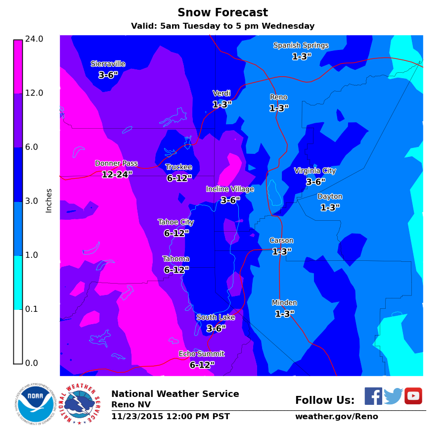
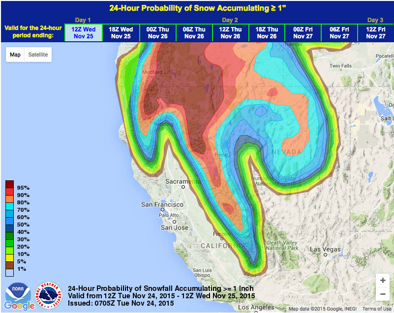
NOAA has raised its snowfall predictions calling for up to 24″ of snow in the northern Sierras today including Donner Summit (see image below).
“Higher elevations of the northern Sierra and extreme southern Cascade Range will see accumulations approaching 2 feet.” – NOAA Sacramento, CA today
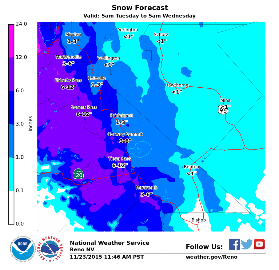
NOAA also upped snow totals for the Mammoth & Yosemite region (*shout out to Bass Lake Summer) and issued a Winter Weather Advisory for the area late yesterday.
* SNOW ACCUMULATIONS: 6 TO 12 INCHES IN BACK-COUNTRY AREAS
  ALONG AND WEST OF HIGHWAY 395...INCLUDING JUNE LAKE AND
  MAMMOTH LAKES. UP TO 6 INCHES EAST OF HIGHWAY 395.
A Winter Storm Warning and Winter Weather Advisory are currently in effect in California. Both of these advisories are in effect from this morning until tomorrow morning.
The highlights of this storm, according to NOAA, will be:
- Coldest air since January 2013
- 1-3″ per hour snowfall rates on Tuesday
- 12-24″ of snow for the high country
- 100mph winds
- Snow ratios as high as 20:1
- Lake effect snow for the east side of Lake Tahoe
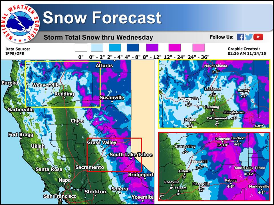
NOAA current Winter Storm Warning is calling for 12-22″ of snow in the next 24 hours.
SNOW ACCUMULATIONS...12 TO 22 INCHES ALONG THE CREST...6 TO 12
INCHES ABOVE 4000 FEET....2 TO 6 INCHES ABOVE 2500 FEET FOR THE
MOTHERLODE AND THE NORTHEAST FOOTHILLS. LOCALLY SNOW MAY FALL AS
LOW AS 1500 FEET. - NOAA Reno, NV today
Lake effect snow could add as much as 10-15″ to already forecast snow totals.
ADDITIONALLY, PERSISTENT WESTERLY FLOW BEHIND THE FRONT WILL
CREATE ADEQUATE CONDITIONS TO SUPPORT LAKE EFFECT SNOW OFF OF LAKE
TAHOE FROM WASHOE VALLEY THROUGH DOUGLAS COUNTY. ADDITIONAL
ACCUMULATIONS COULD RANGE FROM 5 TO 10 INCHES DEPENDING ON HOW
LONG BANDS PERSIST IN ANY GIVEN AREA. - NOAA Reno, NV today
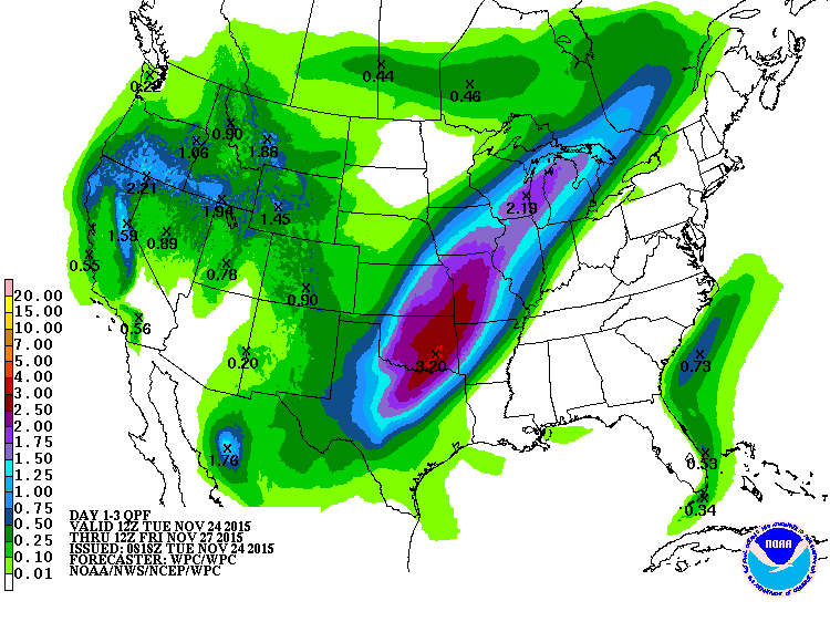
Here is a loop of forecast precipitation across the region today from the NWS HRRR model. Hope it helps with planning your day.
Posted by US National Weather Service Sacramento California on Tuesday, November 24, 2015
(video of the timing of the storm today in California)
***
There are 12 ski resorts open in California right now (& 1 in Lake Tahoe, NV). The resorts further north (higher on this list) have a strong chance of seeing some dry, blower powder this week.
- Boreal
- Sugar Bowl (will open on Thursday)
- Squaw Valley
- Alpine Meadows
- Northstar
- Mt. Rose, NV
- Heavenly
- Sierra-at-Tahoe
- Kirkwood
- Mammoth
- Mountain High
- Snow Summit
- Big Bear
WINTER STORM WARNING for TAHOE TODAY:
URGENT - WINTER WEATHER MESSAGE
NATIONAL WEATHER SERVICE SACRAMENTO CA
330 AM PST TUE NOV 24 2015

...A COLD WINTER STORM WILL BRING HEAVY SNOW FOR THE MOUNTAINS
AND INTO THE UPPER FOOTHILLS TODAY INTO WEDNESDAY...

.A WINTER STORM WILL MOVE INTO THE REGION TODAY. SNOW LEVELS WILL
START OUT BELOW MAJOR SIERRA PASS LEVELS AND RAPIDLY LOWER
THROUGHOUT THE DAY AND MAY REACH THE FOOTHILLS BY AFTERNOON. THE
BRUNT OF THE STORM WILL MOVE THROUGH THIS AFTERNOON AND EVENING
WITH SNOW SHOWERS LIKELY CONTINUING TO IMPACT THE FOOTHILLS ABOVE
2500 FEET THROUGH WEDNESDAY MORNING.

SNOW ACCUMULATIONS...12 TO 22 INCHES ALONG THE CREST...6 TO 12
INCHES ABOVE 4000 FEET....2 TO 6 INCHES ABOVE 2500 FEET FOR THE
MOTHERLODE AND THE NORTHEAST FOOTHILLS. LOCALLY SNOW MAY FALL AS
LOW AS 1500 FEET.

NORTHEAST FOOTHILLS/SACRAMENTO VALLEY-MOTHERLODE-
WESTERN PLUMAS COUNTY/LASSEN PARK-
WEST SLOPE NORTHERN SIERRA NEVADA-
INCLUDING THE CITIES OF...PARADISE...GRASS VALLEY...JACKSON...
CHESTER...QUINCY...BLUE CANYON

...WINTER STORM WARNING REMAINS IN EFFECT FROM 7 AM THIS MORNING
TO NOON PST WEDNESDAY...

* MAIN IMPACT: HEAVY SNOW WILL CAUSE MAJOR TRAVEL PROBLEMS IN
  THE MOUNTAINS AND FOOTHILLS. ROAD CLOSURES AND DELAYS LIKELY.
  DRIVING CONDITIONS NORMALLY SEEN ONLY NEAR PASS LEVELS WILL
  OCCUR AT MUCH LOWER ELEVATIONS.

* CONFIDENCE...HIGH FOR UPPER ELEVATIONS, MEDIUM FOR FOOTHILLS.

* TIMING...SNOW BEGINNING THIS MORNING AND CONTINUING TONIGHT.
  HEAVIEST SNOW EXPECTED THIS AFTERNOON. SNOW SHOWERS WILL
  CONTINUE OVERNIGHT INTO WEDNESDAY WITH SNOW LEVELS DROPPING TO
  AROUND 2000 FEET TONIGHT.

* LOCATIONS...LASSEN PARK SOUTH THROUGH THE WESTERN SLOPES OF
  THE SIERRA NEVADA AND THE ADJACENT FOOTHILLS.

* SNOW ACCUMULATIONS...12 TO 22 INCHES ALONG THE CREST, 6 TO 12
  INCHES ABOVE 4000 FEET, 2 TO 6 INCHES DOWN TO 2500 FEET.

* OTHER IMPACTS...LOW VISIBILITIES POSSIBLE IN HEAVY SNOWFALL.
  THERE COULD BE SNOWFALL RATES OF 1-2 INCHES PER HOUR AT TIMES.
WINTER WEATHER ADVISORY for MAMMOTH TODAY:
NATIONAL WEATHER SERVICE RENO NV
350 AM PST TUE NOV 24 2015

MONO-
INCLUDING THE CITIES OF...BRIDGEPORT...COLEVILLE...LEE VINING...
MAMMOTH LAKES

...WINTER WEATHER ADVISORY REMAINS IN EFFECT FROM 4 PM THIS
AFTERNOON TO 4 AM PST WEDNESDAY...

A WINTER WEATHER ADVISORY REMAINS IN EFFECT FROM 4 PM THIS
AFTERNOON TO 4 AM PST WEDNESDAY.

* TIMING: HEAVY SNOW AND VERY COLD AIR WILL MOVE INTO MONO
  COUNTY LATE THIS AFTERNOON. SNOW WILL DECREASE BY WEDNESDAY
  MORNING BUT SNOW SHOWERS REMAIN POSSIBLE INTO WEDNESDAY
  AFTERNOON.

* SNOW ACCUMULATIONS: 6 TO 12 INCHES IN BACK-COUNTRY AREAS
  ALONG AND WEST OF HIGHWAY 395...INCLUDING JUNE LAKE AND
  MAMMOTH LAKES. UP TO 6 INCHES EAST OF HIGHWAY 395.

* WINDS: SOUTHWEST 15 TO 25 MPH WITH GUSTS TO 45 MPH. SIERRA
  RIDGE GUSTS UP TO 100 MPH.

* IMPACTS: SNOW AND BLOWING SNOW WITH POOR VISIBILITY AND ICY
  ROADS. THIS INCLUDES HIGHWAY 203 AND 395. HAZARDOUS
  CONDITIONS FOR BACK-COUNTRY ACTIVITIES.