30-Day Outlook Discussion for November 2023 (Courtesy of noaa.gov)
El Niño conditions are currently observed, and equatorial sea surface temperatures (SSTs) are above average across the central and eastern equatorial Pacific Ocean. The tropical Pacific atmosphere is consistent with El Niño, and as such we expect El Niño to be the dominant teleconnection for November, though impacts are generally weaker than during winter and early spring. While the Madden Julian Oscillation (MJO) showed some renewed activity recently, an incoherent MJO is favored in forecasts of the Realtime Multivariate MJO (RMM) index given destructive interference from the ongoing El Niño and an emerging positive Indian Ocean Dipole (+IOD) event. Thus, the MJO was not significantly considered for the November Outlook. However, given climatology and a broad-scale environment predicted in the models that is consistent with a Central American Gyre (CAG) formation over the tropical Americas, conditions are favorable for tropical cyclone (TC) development over a broad area from the south of Mexico to the western Atlantic during early parts of November as forecast in the latest CPC Global Tropics Hazards Outlook (GTH). In addition to these influencing factors, the November Temperature and Precipitation Outlooks consider local SST anomalies, dynamical model guidance from the North American Multi-Model Ensemble (NMME), Copernicus model suite (C3S), and the Climate Forecast System version 2 (CFSv2), as well as statistical models that include the influence of trend and ENSO. Week 3-4 forecasts from CFSv2, ECMWF, and GEFSv12 for the early part of November were also considered, as was the expected evolution from the Week 2 forecast period.
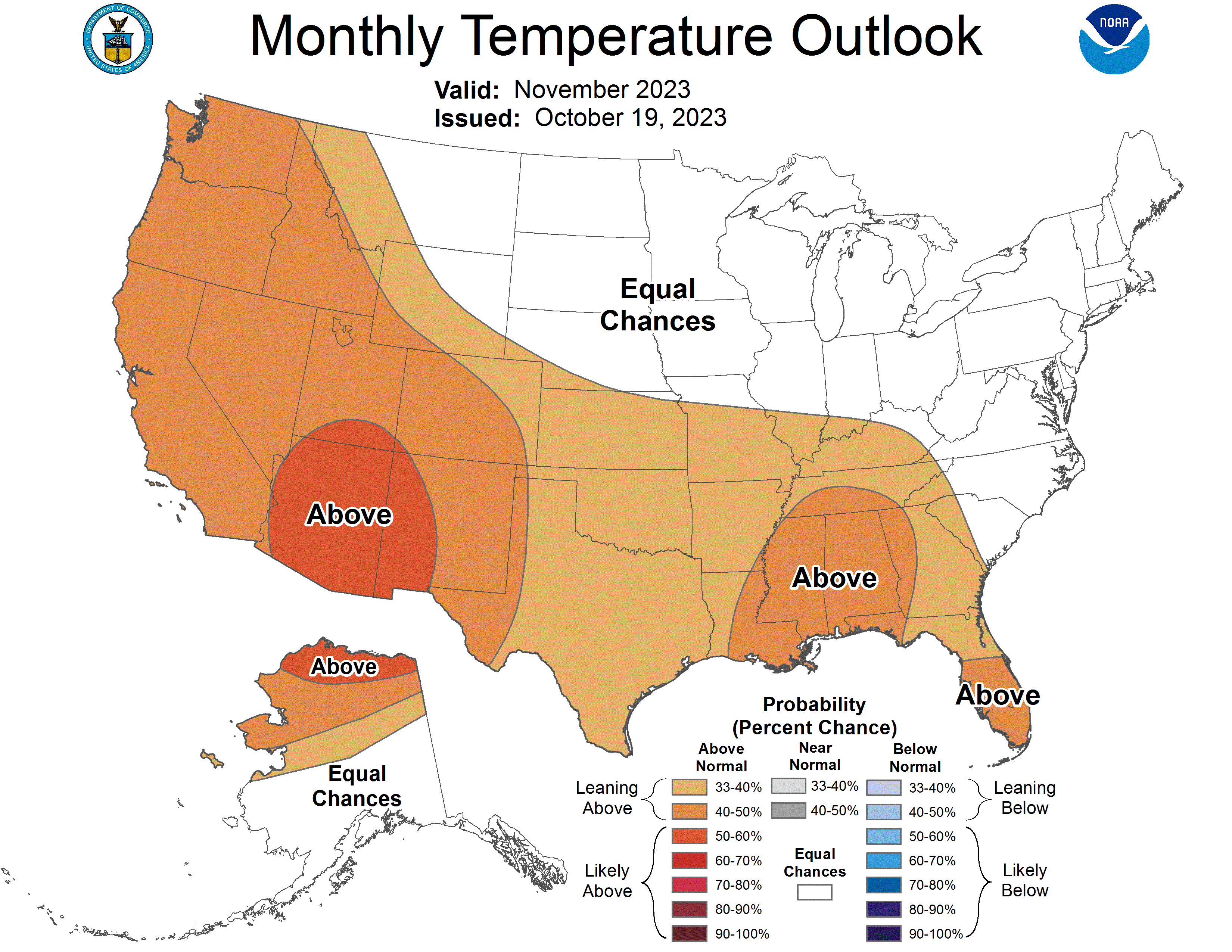
The November 2023 Temperature Outlook favors a broad area of above-normal temperatures for the western contiguous United States (CONUS) stretching into the Southern and Central Plains, the lower half of the Mississippi Valley, the Tennessee Valley, parts of the Ohio Valley, and the Southeast. Week 2 Temperature Outlooks feature a tilt toward below normal temperatures over much of the western CONUS for the period of October 25 through October 1, that shifts eastward toward the central CONUS for October 26 through November 1. In contrast, CFSv2, GEFSv12, and ECMWF predictions of week 3 and 4 temperatures through mid-November broadly favor warming over CONUS, including the western and central parts of the country. This suggests that any potential cooler start to November, particularly over the western CONUS, will be a transient feature with uncertainty on how long it may persist. While recent forecasts from CFSv2 favor strong probabilities for above normal temperatures over the western third of the CONUS, probabilities in the November Temperature Outlook are comparatively damped (40 to 50 percent) to reflect this uncertainty. Higher probabilities (40 to 50 percent) of above normal temperatures are indicated over the Southwest where dynamical models agree. The tilt toward above normal temperatures over the west is also supported by the typical El Niño teleconnection, which favors above normal or milder temperatures over the western half of the CONUS. In contrast, below normal temperatures are more typical over over the eastern half of CONUS during El Niño, however, this is at odds with CFSv2 predictions that favor (relatively) strong probabilities for above normal temperatures over parts of the Mississippi, Ohio, and Tennessee Valleys and the Southeast, and with NMME and C3S predictions that also slightly tilt above normal. A weak tilt toward above normal is maintained over parts of the southeastern CONUS (33 to 40 percent), with higher probabilities (40 to 50 percent) over parts of the Gulf States and Florida Peninsula where there is stronger model agreement, and coincident with above average SST anomalies. Equal Chances (EC) of above, below, and near normal temperatures are indicated for the Northern Plains, Great Lakes, parts of the Mid-Atlantic and New England where statistical tools and dynamical models showed weak or conflicting signals. Mixed positive and negative SST anomalies off the coast of New England adds to uncertainty. Finally, a gradient of above normal temperature probabilities to EC is favored for Northern Alaska to Southern Alaska, with the strongest probabilities of above normal temperatures found over the northernmost part of the state where there was strong model agreement and anomalously warm SSTs.

More uncertainty is apparent in the November 2023 Precipitation Outlook, with EC indicated for a large part of the CONUS given weak and inconsistent model results, and significant day to day differences in recent CFSv2 predictions. A region of favored above normal precipitation is indicated from parts of Texas eastward across the Southeast and up the East Coast of the CONUS. This region of elevated above normal precipitation probabilities is supported by the NMME and C3S, and agrees with the expected El Niño teleconnection and the potential for increased precipitation that may be associated with elevated TC development. However, probabilities are damped given CFSv2 guidance that favors a tilt toward below normal precipitation probabilities. A slight tilt toward below normal precipitation is depicted over the western Great Lakes where NMME, C3S, CFSv2, and expected El Niño teleconnections all support below normal. Both statistical and dynamical models support enhanced probabilities of above normal over Northern Alaska. Guidance is mixed for the southern coast, but recent CFSv2 forecasts consistently favor stronger probabilities of below normal precipitation, additionally supported by a subset NMME and C3S models, and thus below normal precipitation probabilities are elevated over coastal regions.