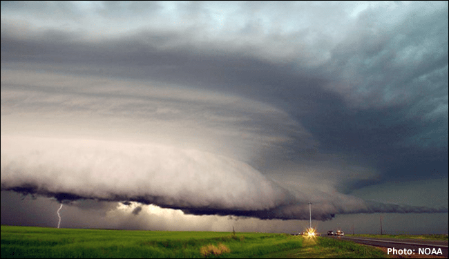
What a wild day Saturday was over the Intermountain West and the western Great Plains! The day started out with a line of severe storms initiating over eastern Utah causing flash flooding in Arches National Park and other surrounding areas. These storms then progressed into Colorado and Wyoming where they maintained their structure. As they did so, they brought destructive winds, hail, and plenty of lighting. Some of the wind reports that came out of Colorado are quite staggering, with a wind gust reported of 110 mph in Winter Park, Colorado! This line of severe storms eventually moved out over the western Great Plains and died out overnight in the Dakotas/Minnesota.
Rare derecho stretching from Utah to the Dakotas today.
A Rocky Mountain special. pic.twitter.com/tkNC8lLRmj
— Dakota Smith (@weatherdak) June 7, 2020
Half a million #lightning events are shown on this map from 7a MT yesterday to 7a MT today capturing the #derecho that started in #UTwx and hit portions of #COwx, #WYwx, #NEwx, #SDwx, #NDwx and #MNwx. Winds as high as 110 mph were measured at the top of @WinterPark! pic.twitter.com/iN97JDhwKp
— Chris Vagasky ⚡️ (@COweatherman) June 7, 2020
Anyone feel the wind yesterday? Just a bit breezy #cowx #9wx #9news pic.twitter.com/xHOGzypbC1
— Kylie Bearse (@KylieBearseWX) June 7, 2020
You may wonder what a derecho is. Well, this is the definition of a derecho in the American Meteorological Society Glossary of Meteorology:
A widespread convectively induced straight-line windstorm.

Specifically, the term is defined as any family of particularly damaging downburst clusters
produced by a mesoscale convective system. Such systems have sustained bow echoes with
book-end vortices and/or rear-inflow jets and can generate considerable damage from
straight-line winds. Damage must be incurred either continuously or intermittently over a
swath of at least 650 km (~400 mi) and a width of approximately 100 km (~60 mi) or more.
-AMS Glossary of Meteorology
So, how rare is it for a derecho to initiate from the Great Basin area? Well, it’s very rare. In fact, there have only been two well-documented cases of this happening in the Great Basin before the event on Saturday, which is pretty remarkable. These are also the only well-documented cases west of the Rockies period.
I put together some quick info on Saturday's derecho event. Only two other derechoes in the Great Basin are well noted in literature. I've included storm reports for those events, as well as a derecho frequency map for comparison. Pretty remarkable event! #derecho #wxtwitter pic.twitter.com/d2KZk1Gvmk
— Elizabeth Leitman (@WxLiz) June 7, 2020
It’s safe to say the weather has been pretty interesting and chaotic over the past couple of days. I guess that goes in line with how 2020 has been so far…