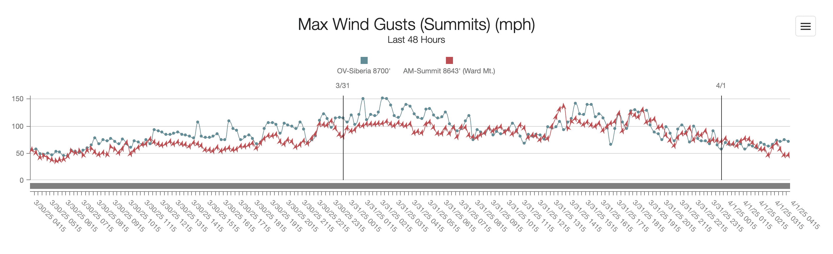
A powerful jet stream over California reached record-breaking speeds of 170 mph on Monday, March 31, creating severe weather conditions across the Sierra Nevada and impacting ski resorts in the Tahoe region. According to the SF Chronicle, the National Weather Service confirmed that these winds, measured at 33,000 feet above Reno, are the strongest recorded for this late in the storm season since data collection began in 1956.
Palisades Tahoe recorded wind gusts of 150 mph early Monday morning, forcing the closure of upper mountain terrain and ski lifts due to hazardous conditions. Other resorts, such as Sierra-at-Tahoe and Mt. Rose-Ski Tahoe, suspended operations as whiteout conditions and avalanche risks escalated.
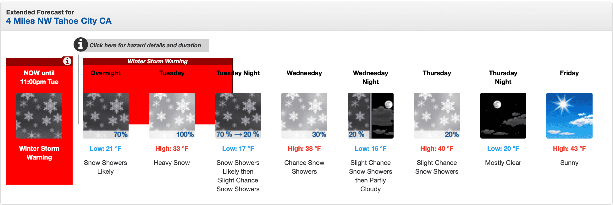
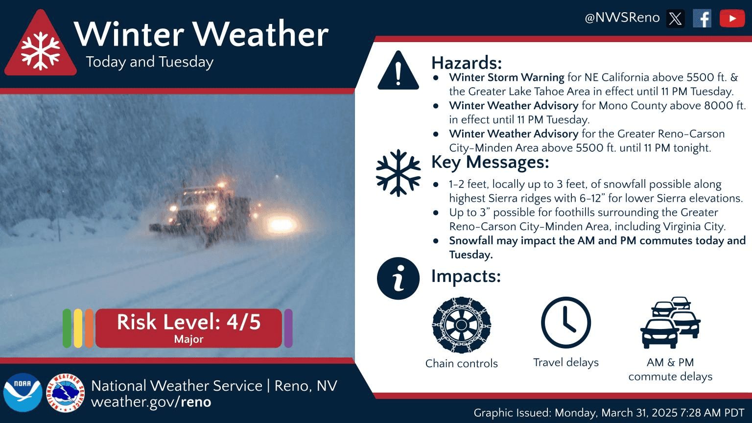
The winds fueled a significant storm expected to deliver up to five feet of snow in higher elevations through Tuesday evening. A Winter Storm Warning is currently in effect through 11 p.m. tonight. The Sierra Avalanche Center issued a “High” avalanche danger warning across the central Sierra range, urging backcountry travelers to avoid steep terrain.
URGENT - WINTER WEATHER MESSAGE
National Weather Service Reno NV
142 AM PDT Tue Apr 1 2025

CAZ072-NVZ002-020600-
/O.CON.KREV.WS.W.0007.000000T0000Z-250402T0600Z/
Greater Lake Tahoe Area-
Including the cities of Truckee, South Lake Tahoe, Markleeville,
Incline Village, Glenbrook, Tahoe City, and Stateline
142 AM PDT Tue Apr 1 2025

...WINTER STORM WARNING REMAINS IN EFFECT UNTIL 11 PM PDT THIS
EVENING...

* WHAT...Heavy snow. Additional snow accumulations between 8 to 16
  inches above 6500 feet with additional snow accumulations between
  5 to 12 inches below 6500 feet. Locally higher snowfall amounts up
  to around 2 feet possible at the highest elevations. Ridge winds
  gusting as high as 70 mph. Lake Tahoe winds west-southwest gusting
  up to 40 mph with waves of 2 to 3 feet.

* WHERE...Greater Lake Tahoe Area.

* WHEN...Until 11 PM PDT this evening.

* IMPACTS...Travel could be very difficult to impossible. The
  hazardous conditions could impact the Tuesday morning and evening
  commutes. Strong winds could cause damage to trees and power lines.

PRECAUTIONARY/PREPAREDNESS ACTIONS...

If you must travel, keep an extra flashlight, food, and water in
your vehicle in case of an emergency. The latest road conditions for
the state you are calling from can be obtained by calling 5 1 1.
This extreme weather event also disrupted air travel and affected trans-Pacific flights. Several flights from Asia to San Francisco International Airport landed nearly an hour ahead of schedule due to tailwinds from the jet stream. Meanwhile, firefighting aircraft were grounded near Bishop on Sunday evening as strong winds made operations unsafe.