Forecast By SnowBrains Meteorologist – Eric McNamee
Brought to you by Monarch Mountain
3:30 PM MST, 3/11/2021
Forecast Summary:
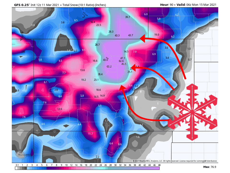
An upper-level low off the West Coast is expected to dig into the Southwest US and cut off, bringing 2-4 FEET of snow across the Colorado Front Range this weekend.
Before then, minimal snowfall totals are expected.
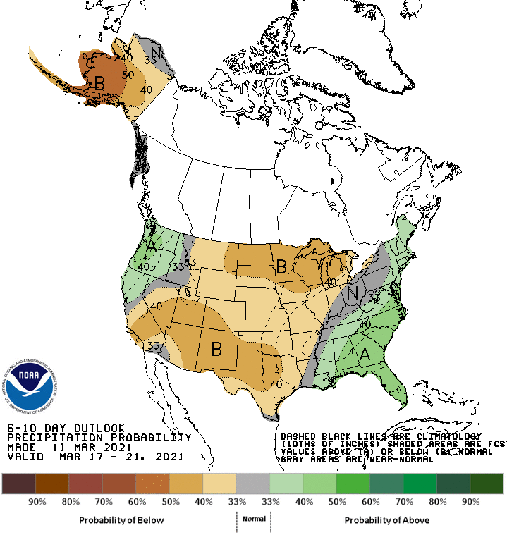
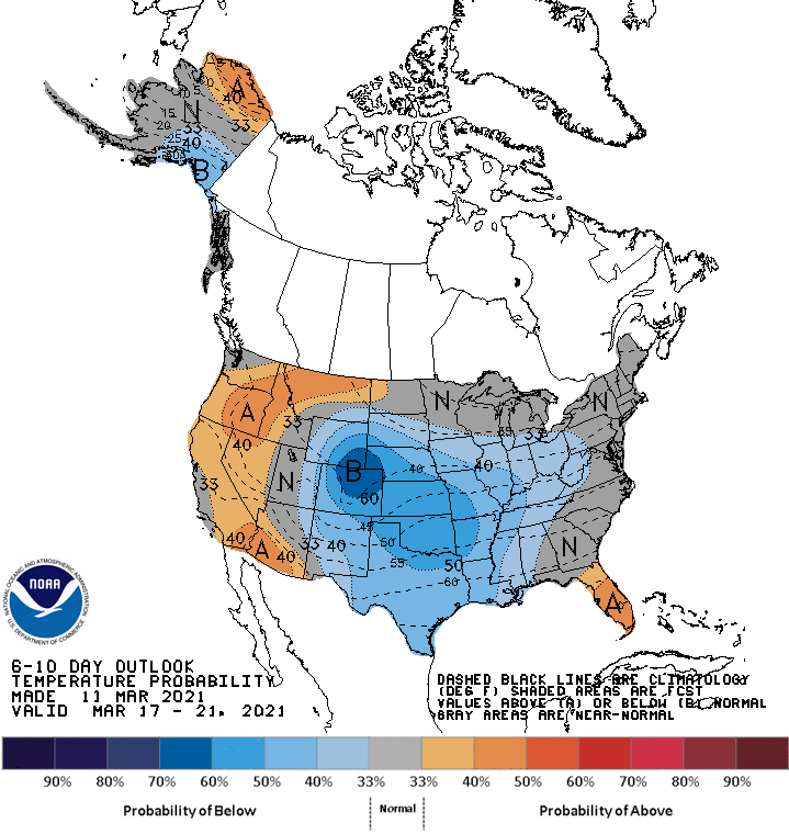
Below-average temperatures and below-average precipitation in the extended.
Resorts that look to see the most snow are Aspen, Vail, Arapahoe Basin, Steamboat, Keystone, Copper Moutain, Breckenridge, Telluride, Monarch, Wolf Creek, Winter Park, and Crested Butte.
Short-Term Forecast:
Thursday-Saturday:
Conditions will be relatively dry through Friday ahead of the closed low moving into the state.
By Saturday, snow will start to fill in across the Front Range and pick up in intensity through the day as moist air is advected into the state.
By Saturday night, the meat of the intense upslope snowfall will begin.
Long-Term Forecast:
Sunday-Wednesday:
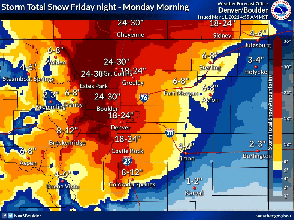
By the end of the day Sunday there will have been 2-4 FEET of snow accumulations across the Front Range, with locally Higher Amounts (Foothill locations).
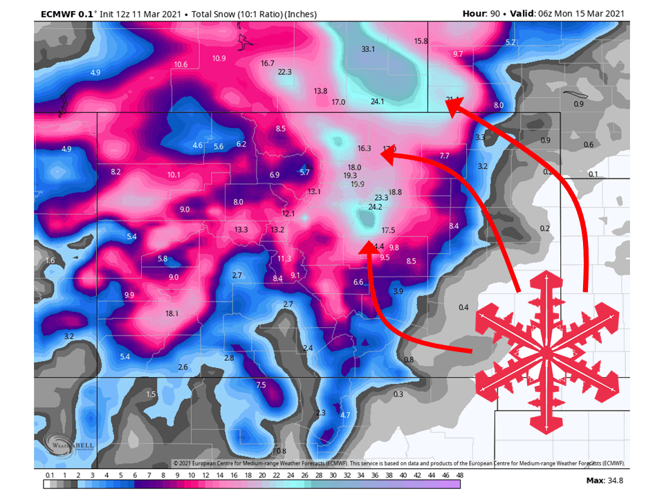
The amount of snowfall will be crucial on the positioning of the low due to the positioning of the TROWAL.
If the center of the low is located near the Colorado/New Mexico border (what the GFS and Canadian model are showing), then snow totals will be on the high end of the 2-4 feet.
If the center of the low is located over Southeast CO (what the ECMWF shows), then totals will be on the lower end of the 2-4 feet.
Regardless of the outcome, this will be a high-impact event from roughly Monument, CO to Cheyenne, WY, with nearly impossible travel at times Sat/Sun.
By late Saturday and into Saturday night, the cut off trough will
enter southern Colorado. The exact positioning of the trough will be
crucial for determining snowfall amounts across our forecast area.
This is because the trough position will determine the position
of the TROWAL which will be the mechanism that will create the
heaviest snowfall bands and totals from this storm. A track that
is farther to the south would mean higher amounts for our area
with a farther north track meaning less snow. The ECMWF has
continued its trend of being slightly farther north than the rest
of the models and has lower snow amounts because of that. The GFS
and Canadian are slightly farther south with higher snowfall
totals. At least initially, the TROWAL will be over our forecast
area Saturday night and this period is expected to have the most
widespread moderate to heavy snowfall. With easterly low level
winds as high as 45 knots slamming up against the foothills,
snowfall rates could be very impressive. I have snowfall rates of
nearly 3 inches per hour in the foothills in the forecast Saturday
night which means travel would be impossible. Snowfall rates
decrease moving to the east off the foothills in part due to
lower snow ratios. Boulder and Fort Collins could see snowfall
rates of around 2 inches per hour during this period. There is
potential for a dry slot to limit snowfall south of I-70
especially if the trough were to take a more northern route.
Changes to the forecast were mainly focused on increasing QPF and
snowfall in the foothills and near the Cheyenne Ridge while
decreasing the amounts south of Denver.

The system will become vertically stacked on Sunday as it almost
becomes stationary over far southeastern Colorado or western
Kansas. This will weaken the system and snowfall rates are
expected to decrease substantially. The TROWAL will most likely be
to the north of Colorado during this period so the potential for
heavy snowfall will be much lower. The overall model trend has
been toward the ECMWF solution which has been slower with the
eastward progression of the trough and weaker with the trough and
surface cyclone. The chance for snow will linger into Sunday night
and Monday morning before ending around midday Monday. Winds
should be strongest during the day Sunday with blowing and
drifting snow possible. Gusts could reach up to 45 mph across the
plains which may create near blizzard conditions at times.
-NWS Boulder 3/11/2021
Extended Forecast:
Wednesday and Beyond:
Global ensembles are indicating below-average temperatures across Colorado, with below-average precipitation.