This forecast was created at 8:00 a.m. on Monday, March 17, 2025
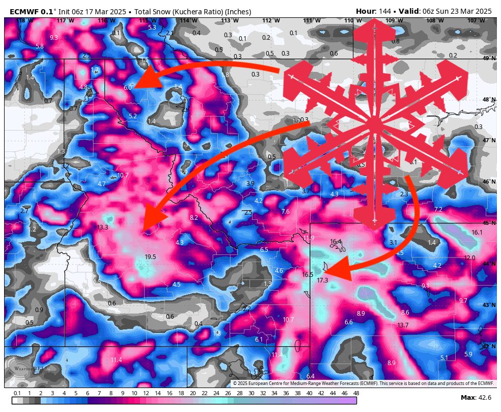
A series of storms will traverse the Northern Rockies this week, delivering occasional moderate to heavy snowfall in many mountain areas before tapering somewhat toward Sunday. The most notable snows arrive in waves: an early-week system impacting Idaho, Montana, and Wyoming through Tuesday, a brief lull Wednesday, then multiple impulses returning from Thursday onward. Overall, snow levels remain relatively low, especially in Idaho’s higher terrain, and snow quality looks solid thanks to widespread Snow-to-Liquid Ratios (SLRs) in the 10–15+ range. Conditions quiet a bit by late Sunday into Monday, with only scattered light snow showers lingering in some locales and little clarity on the longer-range pattern beyond that point.
The Monday–Tuesday storm has already brought fresh snow to Idaho, Montana, and Wyoming mountains. Idaho’s central and southeastern mountains continue to pick up several more inches, with some locales likely pushing 5–10 inches by late Tuesday, especially in higher terrain. Montana’s Madison and Gallatin ranges hold onto additional accumulations through Tuesday morning, though snowfall gradually tapers from north to south. Meanwhile, Wyoming’s western mountains are scoring moderate snow totals with SLRs commonly above 10:1, supporting fair to good snow quality; gusty winds in spots may lead to some blown-around powder, but overall coverage and texture should remain enjoyable for skiing.
High pressure offers a brief midweek break on Wednesday before the pattern turns unsettled again on Thursday. A Pacific trough reintroduces widespread snowfall starting late Wednesday night, mainly affecting Idaho, Montana, and Wyoming from Thursday into Friday. Snow levels hover around 2,500–4,000 feet in Idaho, keeping most mid-to-upper mountain terrain safely in snow. Mountain winds become moderate to occasionally strong, with gusts commonly reaching 30–45 mph. Snow quality during this period remains respectable, with many spots again in the 10–14:1 SLR range. While accumulations may be lighter in some northern sections (including parts of Montana and the Idaho Panhandle), all mountain areas are poised to see some fresh coverage.
Another round of moisture keeps the action going into Friday night and Saturday, bringing potential heavier snowfall to higher elevations. Idaho’s higher terrain could pick up renewed moderate totals, and Wyoming’s mountains see continued accumulations into Saturday as well. By Sunday, intensity diminishes in most areas, though light snow showers linger across parts of Idaho, Montana, and Wyoming, with snow levels inching upward (particularly in Idaho, where they may approach 5,000–7,000 feet). Beyond Sunday, details are hazy due to limited longer-range guidance, but the general expectation is for periodic weak systems or unsettled weather to remain possible. Enjoy the fresh powder where it lands this week, with the best bet for deeper pockets likely mid to late in the period.
Resort Forecast Totals
- Grand Targhee – 17”–30” total (8”–12” Mon (03/17) – Wed (03/19) + 9”–18” Wed night (03/19) – Sun (03/23))
- Brundage – 10”–21” total (2”–4” Mon (03/17) – Tue night (03/18) + 8”–17” Wed night (03/19) – Sun (03/23))
- Jackson Hole – 10”–19” total (4”–6” Mon (03/17) – Tue night (03/18) + 6”–13” Wed night (03/19) – Sun (03/23))
- Schweitzer – 8”–15” Wed night (03/19) – Sat night (03/22)
- Big Sky – 6”–12” total (2”–3” Mon (03/17) – Wed (03/19) + 2”–4” Thu (03/20) – Fri (03/21) + 2”–5” Fri night (03/21) – Sun (03/23))
- Bogus Basin – 5”–10” total (2”–3” Mon (03/17) – Tue night (03/18) + 3”–7” Wed night (03/19) – Sat night (03/22))
- Sun Valley – 3”–7” total (2”–4” Wed night (03/19) – Thu night (03/20) + 1”–3” Fri (03/21) – Sat night (03/22))
- Bridger Bowl – 2”–5” total (1”–2” Mon (03/17) – Tue night (03/18) + 1”–3” Fri night (03/21) – Sat night (03/22))
- Whitefish Mountain – 1”–4” Fri night (03/21) – Sat night (03/22)