This forecast was created at 1:30 p.m. PST on Friday, March 28, 2025.
An active stretch of weather will unfold over the Northern Rockies through next week, bringing multiple waves of mountain snowfall that should keep surfaces fresh and conditions fairly wintry across Idaho, Montana, and Wyoming. In particular, southwestern Montana and portions of central Idaho look primed for the healthiest accumulations through the weekend, with another round of region-wide snow likely returning Monday into Tuesday. Snow levels will fluctuate day to day but remain low enough for mountain snow to dominate, and modest to occasionally higher snow-to-liquid ratios will keep the quality decent. A brief lull midweek leads into more unsettled weather, while extended outlooks suggest temperatures may stay near or slightly below normal for early April, maintaining a decent spring snowpack.
Friday–Saturday Storm Showers are already developing across the region, with modest accumulations expected by Saturday. Snow levels in Idaho will range mostly between 4,000 and 6,000 feet, remaining high enough that only the upper portions of many mountains see meaningful snowfall. Southwest Montana will be a notable exception on Saturday, where colder air lowers snow levels significantly and leads to heavier mountain accumulations. Overall, the snow will be modest in most spots but should freshen surfaces, with snow quality on the fair side (roughly 9–12:1 ratios) in central Idaho and southwestern Montana.
Saturday Night–Sunday Break By Saturday night, southwestern Montana mountains continue to see periods of snowfall, potentially topping out around a foot in favored higher terrain before a more noticeable lull arrives on Sunday. Further south into Wyoming, widespread precipitation Saturday evening will transition to lighter snow overnight, while Idaho’s mountains gradually taper off to only isolated showers. Sunday itself looks drier across much of the region, but temperatures will remain cool enough that any lingering snow should stay intact at upper elevations. This brief window of calmer weather will allow ski conditions to remain relatively good, especially on fresh upper-mountain surfaces.
Monday–Tuesday Storm Another wave arrives on Monday, kicking off a new round of mountain snow that intensifies Monday night through Tuesday. Many Idaho mountains, including the Panhandle and central ranges, will see snow levels around 3,500–5,000 feet, though daytime rain or a mix can occur at lower elevations. Wyoming’s ranges and the Montana mountains should also pick up steady snowfall; snow-to-liquid ratios look mostly moderate (around 10–15:1), so expect decent, fairly light snow in the higher elevations. Gusty winds may accompany this system in exposed areas, which could impact the overall ski experience if sustained through Tuesday afternoon, but fresh accumulations should be respectable.
Wednesday–Thursday & Extended Outlook A partial break is anticipated Wednesday, though unsettled conditions will linger in some Idaho and Washington border mountains, possibly extending into Thursday with additional light or moderate snowfall. Elsewhere, dry spells will help consolidate fresh snow before any late-week showers develop. Looking farther out, the medium-range outlook hints at near to slightly below normal temperatures continuing across the Northern Rockies, potentially preserving the snowpack into early April. While confidence decreases late in the period, the pattern may transition to slightly drier conditions after a final bout of cooler air, which could keep spring skiing decent for those still chasing powder.
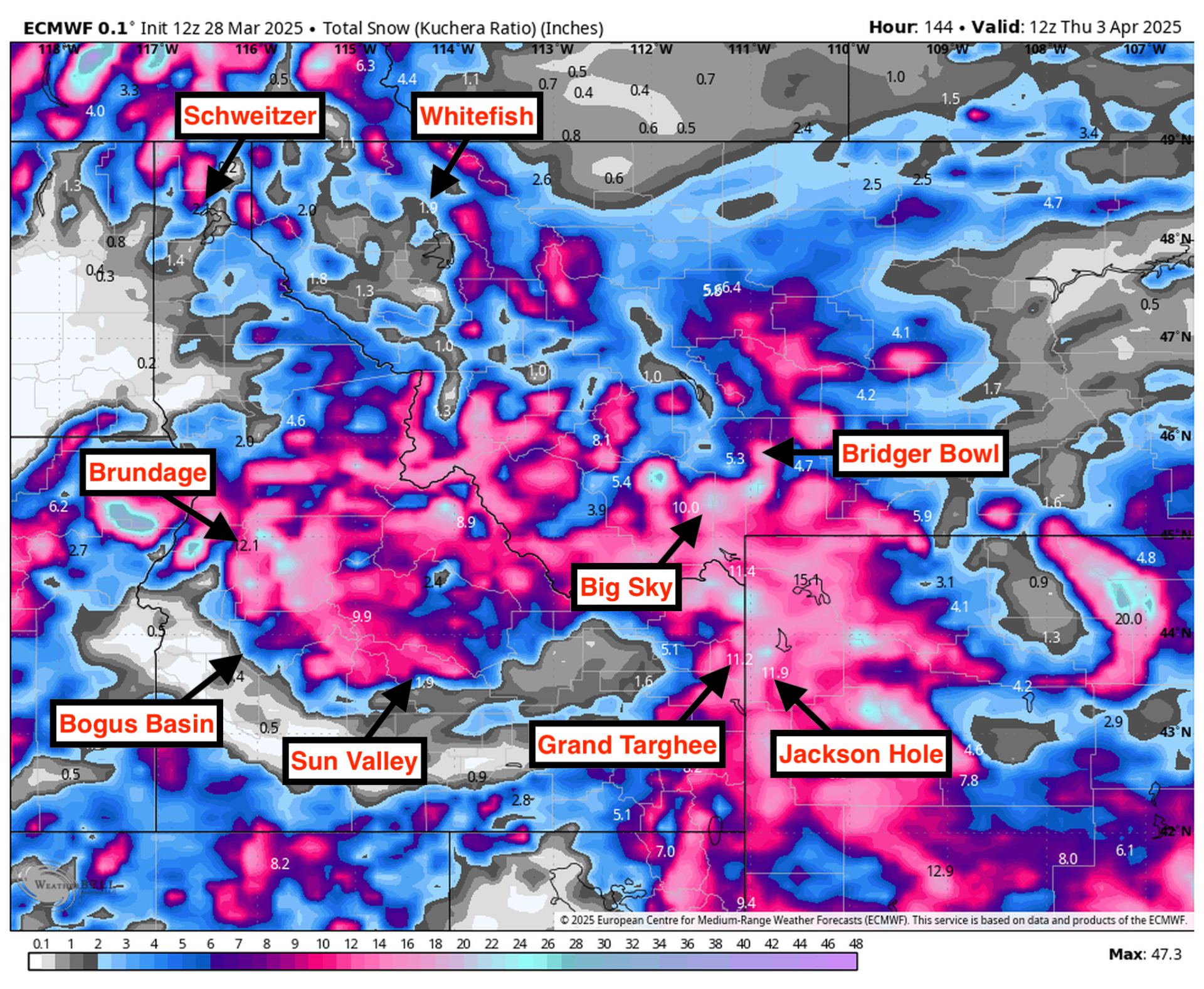
Resort Forecast Totals
- Grand Targhee – 10″-21″ total (2″-4″ Sat night (03/29) – Sun night (03/30) + 8″-17″ Sun night (03/30) – Thu (04/03))
- Big Sky – 10″-18″ Fri night (03/28) – Thu (04/03)
- Brundage – 8″-17″ total (1″-3″ Fri (03/28) – Sat night (03/29) + 7″-14″ Sun night (03/30) – Thu (04/03))
- Bridger Bowl – 8″-15″ total (5″-8″ Fri night (03/28) – Sun night (03/30) + 3″-7″ Mon night (03/31) – Wed (04/02))
- Jackson Hole – 6″-12″ Sun night (03/30) – Thu (04/03)
- Bogus Basin – 5″-10″ total (2″-3″ Fri night (03/28) – Sat night (03/29) + 3″-7″ Sun night (03/30) – Tue night (04/01))
- Sun Valley – 2″-5″ Sun night (03/30) – Tue night (04/01)
- Schweitzer – 2″-4″ Sun night (03/30) – Tue night (04/01)