Forecast By SnowBrains Meteorologist – Eric McNamee
Brought to you by Alta Ski Area
11:50 AM MST, 12/10/2020
Forecast Summary:
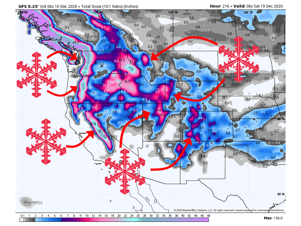
1-5 FEET of snow is expected across the western US over the next week as a major pattern change takes place.
The Ridge of Death that has been parked over the western US for the past two weeks looks to break down as a longwave trough develops.
Different regions of the West will see rounds of snow at different times.
Short-Term Forecast:
Friday-Sunday:
This pattern will start by dropping around 12-18″ of snow for portions of the Cascades as two shortwave troughs move through this weekend.
These two same shortwaves will traverse across the western US, bringing 6-10″ of snow to portions of Colorado.
Around 4-8″ of snow is also expected along the Sierra’s of California and the Wasatch Mountains in Utah.
Other regions will see relatively lighter accumulations through the short-term with 2-6″ of snow likely.
Long-Term Forecast:
Monday-Thursday:
Getting into the long-term, another shortwave looks to move through the west before a tight pressure gradient develops.
Because of this, high amounts of moisture will stream into the western US and bring additional FEET of snow.
Areas that will likely be favored in this pattern are Northern California, Pacific Northwest, Northern Rockies, and Northern Utah.
Extended Forecast:
Friday and Beyond:
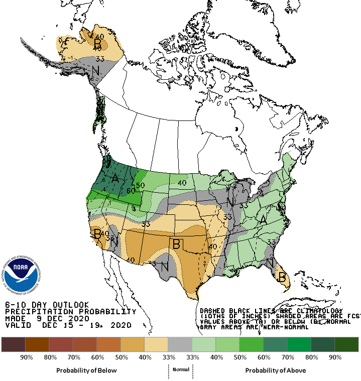
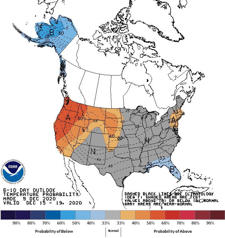
Global ensembles are indicating a typical La Niña pattern will persist in the extended period.
This means above-average snowfall is likely across the Northwest and below-average snowfall across the Southwest.
This seems to continue through the foreseeable future as well.
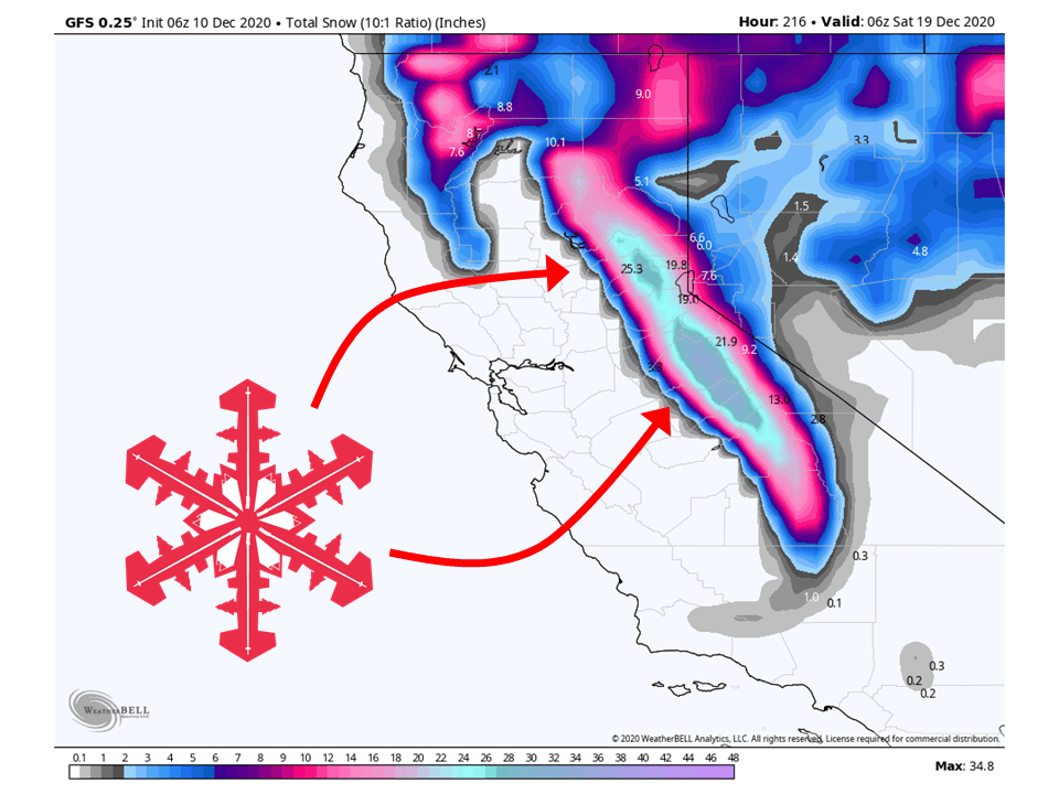
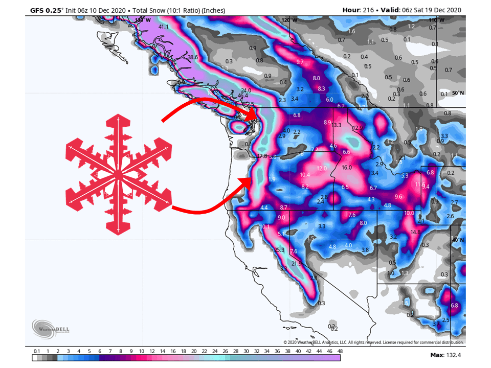
California:
4-8″ of snow is expected across the Sierra’s through Sunday as the initial trough digs down the west coast.
After this weekend, an unsettled and wet pattern develops, bringing at least an additional 8-12″ of snow for the northern Sierra’s.
Resorts likely to get the most snow are Boreal, Kirkwood, Sugar Bowl, Squaw, Alpine, Northstar, Homewood, and Heavenly.
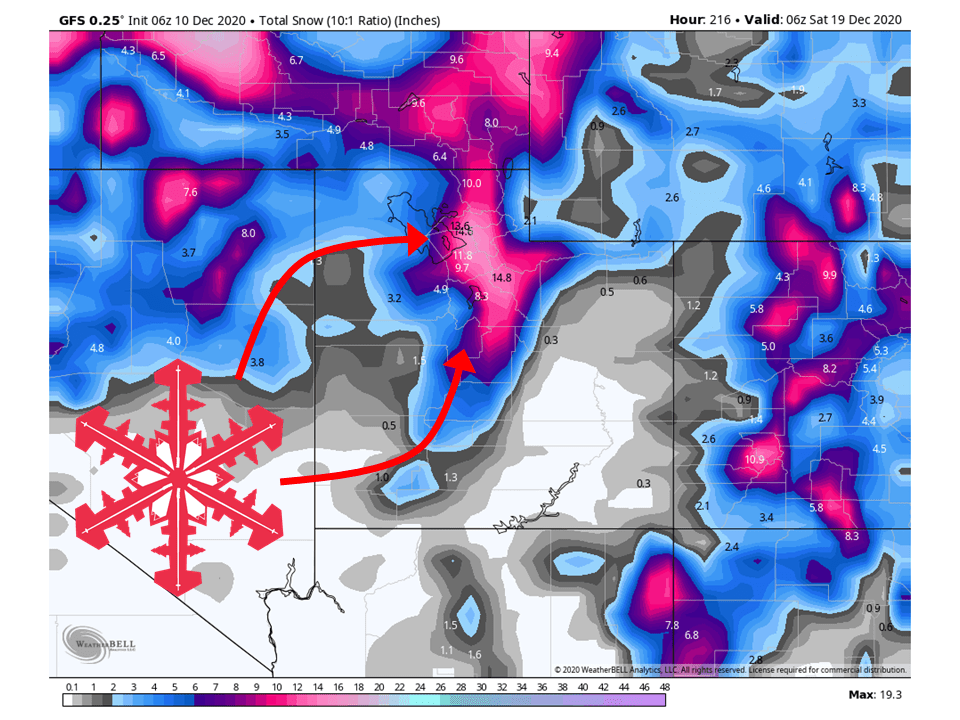
Utah:
Like California, Utah will see 4-8″ of snow this weekend from the initial shortwave troughs.
The pattern getting into next week will favor northern Utah, specifically the Wasatch Mountains, bringing at least an additional 8-12″ of snow as well.
Resorts that look to be favored are Alta, Snowbird, Brighton, Solitude, Park City, Canyons, Deer Valley, Snowbasin, Powder Mountain, and Beaver Mountain.
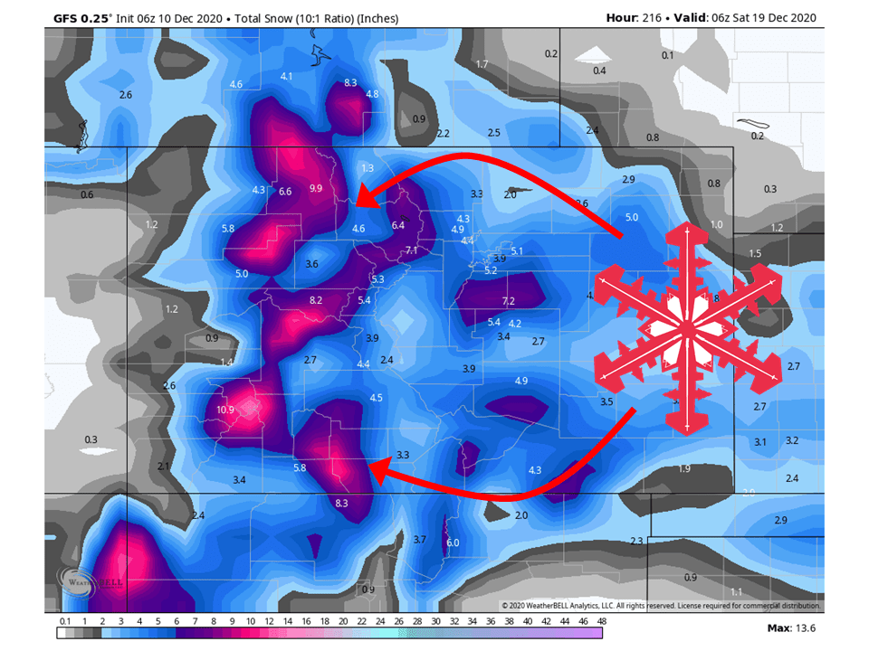
Colorado:
6-10″ of snow is expected across the mountains of Colorado this weekend as a closed low moves through the state.
The pattern developing next week will bring additional snowfall to Colorado, primarily the northern part of the state.
Resorts that look to see the most snow are Aspen, Steamboat, Vail, Wolf Creek, and Winter Park.
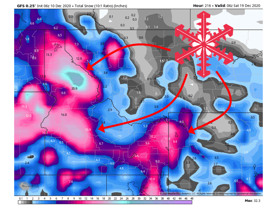
Pacific Northwest:
The Pacific Northwest looks to see 12-18″ of snow this weekend as the first two initial troughs move through.
With the pattern developing next week, the Pacific Northwest looks to the most snow across the west this next week.
An additional 2-4 FEET of snow is possible through Friday of next week.
Resorts that look to see the most snow are Mt. Bachelor, Timberline Lodge, Crystal Mountain, Stevens Pass, Alpental, and Mt Baker.
Northern Rockies:
The Northern Rockies will see relatively lighter snowfall amounts this weekend, with 2-6″ of snow falling in most spots.
The northern Rockies will really start to see some actions next week with the wet pattern developing.
1-2 FEET of snow is possible through Friday of next week for potions of the region.
Resorts that look to see the most snow are Jackson Hole, Targhee, Big Sky, Big Moutain, and Schweitzer.
USA:
Global ensembles are indicting a typical La Niña will continue through the extended period of the forecast.
This means above-average snowfall for the Northwest and below-average snowfall for the Southwest.
- Related: Long Anticipated La Niña Pattern Set to Engage in Intermountain West Before Christmas
- Related: Mountain Weather Update: Heavy Snow Possible for Parts of Utah, Wyoming, and Colorado This Weekend Through Tuesday