Forecast Summary:
A moisture-rich atmospheric river event associated with a powerful mid-latitude cyclone is forecasted to bring significant precipitation to California this weekend. Most of Northern California will see rainfall totals between 3-12″ with the possibility of upwards of 60-70″ of snow in the High Sierra.
Friday-Saturday:
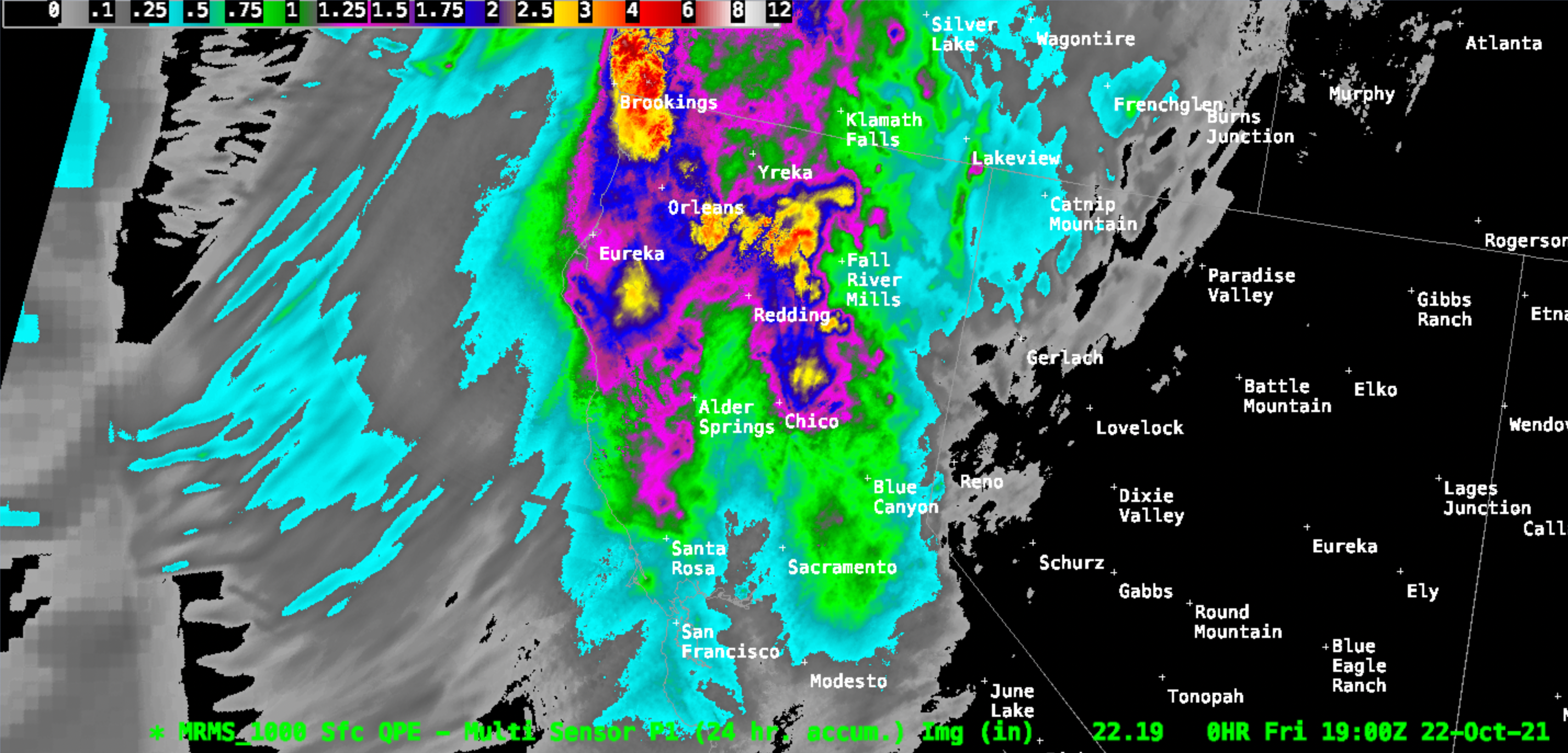
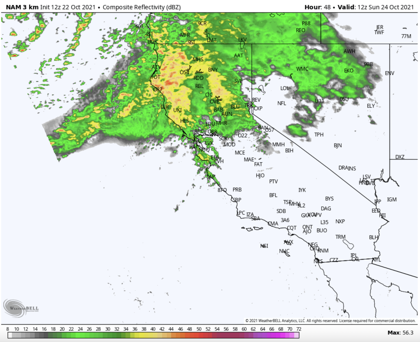
A preliminary band of moisture pushed through Northern California Thursday evening and Friday morning, dropping totals of as much as 4″ of rain in the region. Below is our “best guess” of 24-hour precipitation based on radar and satellite observations:
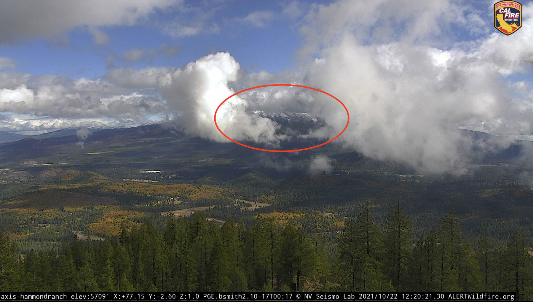
Some accumulated snow could be seen through the clouds on Mt. Shasta, seen here from the Hammond Ranch AlertWildfire webcam:
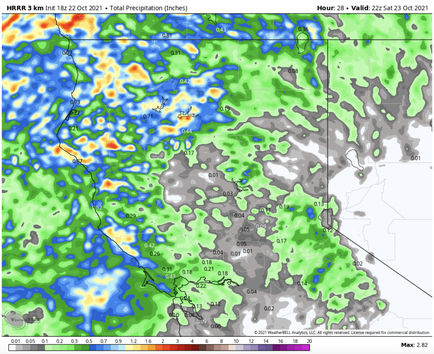
The remainder of Friday and most of Saturday will see unorganized showers continuing to wet the region. With a lack of cohesive synoptic structure, these showers produce patchy precipitation totals on the model outputs. Accumulations may inch up to as much as 3 inches in the coastal mountains by tomorrow afternoon but should remain under 0.3-0.5″ in most areas of the region. Below is forecasted precipitation accumulation through 3 pm on Saturday:
Sunday-Monday
Sunday and Monday will see the highest precipitation totals for the region. The first big surge of moisture and precipitation will arrive in Northern California at around 6 pm on Saturday, with showers increasing overnight. By early Sunday morning, nearly all of the Northern area of the state will be seeing consistent rain showers and snow above 8,000 feet.
The plume of moisture will continue to inch south, bringing increasingly high precipitation rates to the Northern Sierra mountains. The Lake Tahoe region will see itself in the primary moisture plume for upwards of 24 hours.
Past Monday afternoon, the remaining moisture will continue its march down the Sierra Crest until it finally dissipates late at night on the 25th.
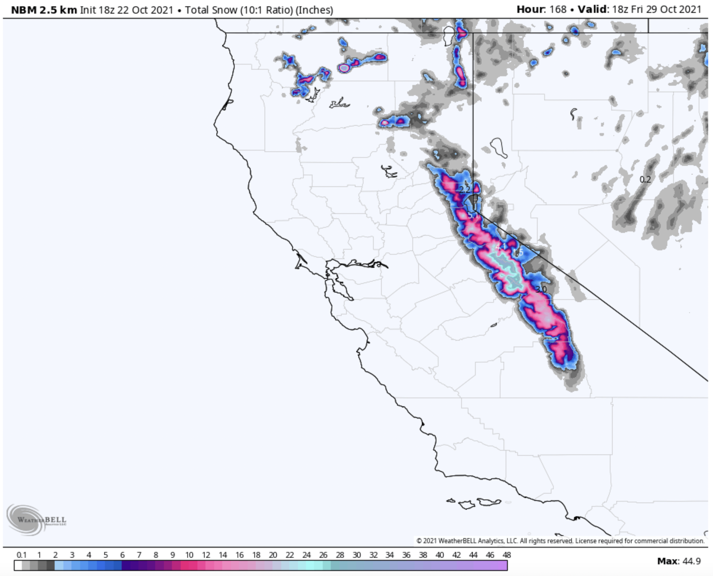
In terms of precipitation totals, the highest totals will be found in the Northern Sierra region of the state. The models are all onboard with upwards of 10-12″ in this area. Upper peaks along the Sierra Crest in the Lake Tahoe region will receive similar totals. The coastal mountains will also do quite well, with totals of between 6-10″. Precipitation totals begin to wane in the Sierra further south, but should still be in the 6-8″ range.
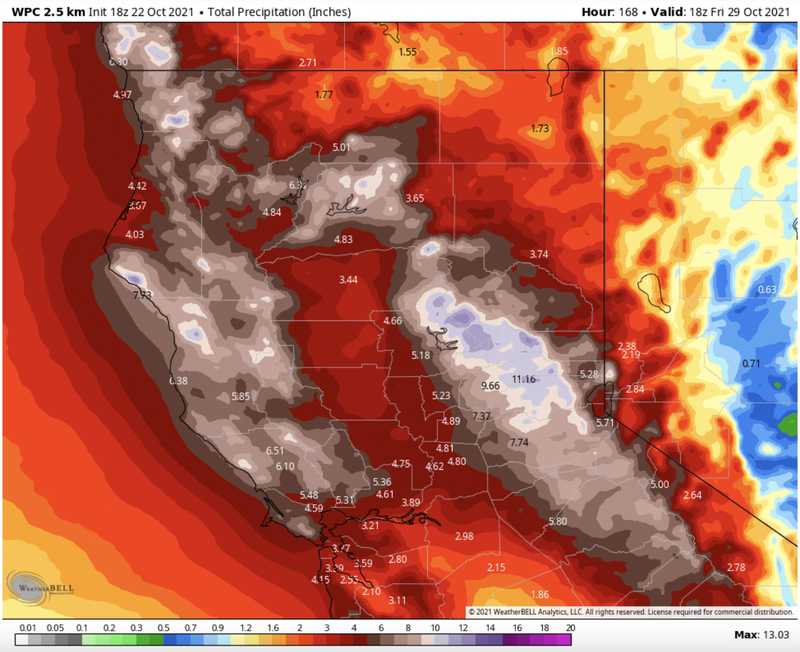
The trickiest part about forecasting snow for this storm will be the snow levels (the elevation at which precipitation falls as snow). This system is tapping into a lot of warm Pacific moisture, so while it will be bountiful in moisture, it will also come in relatively warm. On Sunday afternoon, snow levels may climb to as high as 9,000 feet or so, meaning most peaks in the Tahoe region will receive at least some rain during the storm. However, the average snow level throughout the storm should be at about 7,500 feet, meaning most of the upper elevations will receive good snow totals. Snow/sleet is probable down at the lake level at some point, but the precipitation will fall almost exclusively as rain at those elevations.
30-40″ is the most likely maximum total range in the Tahoe region. These totals will definitely be found on the Western side of the lake along the Sierra Crest. Just slightly further south in the Carson Pass area near Kirkwood are some higher peaks above 10,000 feet which will not see any rain during the storm. Totals closer to 60 inches are more likely on upper aspects in this region.
The higher peaks near Yosemite will likely end up being the winners of this storm, with totals of up to 70″ looking likely. While this region is receiving slightly less overall precipitation than the Tahoe region, the higher elevations and thus colder temperatures will increase the snow liquid ratio, producing more snow for every inch of water that falls.
Mammoth is looking at likely totals of 30-40″ at the summit, but further south, the precipitation totals really begin to drop off, and totals of just 20-30 inches are forecasted for even the highest peaks.
I am trying to get in touch with Clay Malott
And KT22 might not even open this year am hearing from very reliable sources as per CA OSHA ski lift oversight saftey concerns due to the unfinished gondola construction project because the unfinished mess left by excavation debris and rebar in concrete foundation etc etc.
So there ya go s-NO-wbrains who hyped this 3rd largest ski area in NA bs, some of the most lift access world class terrain may not even be accessible due to such nonsensical decisions by executive management from KSL Alterra Mountain Co etc etc.
Oh and as far as safety goes, anyone even think about post control avy danger on the mountain run if west face runs and Chute 75 etc don’t get a skier pack after deep snow storms and continue to build up throughout the season? Hmmmm yah great decision making there Palisades Tahoe KSL AMC Andy Wirth Rust Gregory Ron Cohen etc etc
Keep Standing in Line
Already More Crowded
Looking at the NOAA pinpoint forecast for Mt Shasta there is a 64 tp 88 inches predicted at elevation 11,400, which should be all snow for the duration. MOAA says 33-39″ Sunday and 13-10″ Sunday night at Shasta. That is a massive storm regardless of the month. Yes, there are bigger storms but not in a short period of time every year–Most of the big dumps happen over several days. The problem with this one is the early snow in Tahoe area will get erased by the high snow levels until the storm veers south and the cold air lowers the snow level…the amount of precipitation after the temps drop is really tough to predict without asking the storm when it plans to move south.
Clay,
You are counting the chickens before they hatch and you are claiming snow amounts that will be well above the elevations most of the Tahoe resorts. As far as “huge” snow amounts for October, you need to do a little research bud. Tahoe has seen plenty of big Octobers, have you ever heard of the Donner Party? Boreal has opened on or before Halloween plenty of times with natural snow.
Why do you say “60-70” of snow in October is absolutely “huge” snow totals and is the type of storm that we only see a few times in the *winter* in California.” When you live in Colorado?
At 10,000 feet MAYBE
I just got a massive snow boner
I guess it’s a sign of the times? 30-40″ isn’t massive for the Sierra Nevada Mountains. Nor is 60-70″, which is definitely a big amount but by no means MASSIVE. Once the totals break the 100″ mark, you can think of it as a really big storm total. 1-3′ used to be the norm around here.
60-70” of snow in October is absolutely “huge” snow totals and is the type of storm that we only see a few times in the *winter* in California. Having temperatures and moisture supply cooperate and bring this much snow with a fall storm like this is uncommon and absolutely a noteworthy occurrence.