Forecast by SnowBrains Meteorologist Nathan Tarino – Feb 4th 2023
Forecast Summary
Snow conditions have been top-tier the past few days. Calm weather behind a recent storm has allowed for quite a few rope drops, and fresh turns haven’t been too hard to find. Stability in the backcountry has allowed for the skiing of some more intense lines, too.
Another storm is on the way, bringing accumulating snow across Utah Sunday afternoon into Monday. Accumulations will be heaviest in the Cottonwoods, but all of Utah’s mountains will offer soft turns on Monday.
The long term forecast looks fairly promising as well.
Short Term Forecast
Dry weather will continue until Sunday afternoon for most of Utah. Expect gross, hazy air and poor air quality to continue to be an issue along the Wasatch Front until then.
A cold front will push into the northwestern portion of the state by midday Sunday, reaching the ski hills of northern and central Utah sometime in the afternoon. A burst of heavy snow will accompany the passage of the front, quickly piling up a couple of inches of new snow. Latest model guidance has the band pushing into the Cottonwoods/Park City area around 2-3 pm, not leaving a ton of time for accumulations while lifts spin on Sunday. Still, a few softer turns will be found on the last couple of laps.
A pretty great postfrontal mountain snow environment looks to set up through much of the day Monday. Moist, unstable northwesterly flow coupled with a few embedded upper level disturbances should foster continued accumulating snow through Sunday night and Monday morning, lingering as long as Monday evening for the Cottonwoods. Setups like this are what give the Cottonwoods their huge annual snowfall numbers.
Low density snow over the course of the day Monday will make for great conditions across the state.
You can see this easily on the U of Utah’s time-height charts available here (great website to check out if you’re a Utah snow snob by the way):
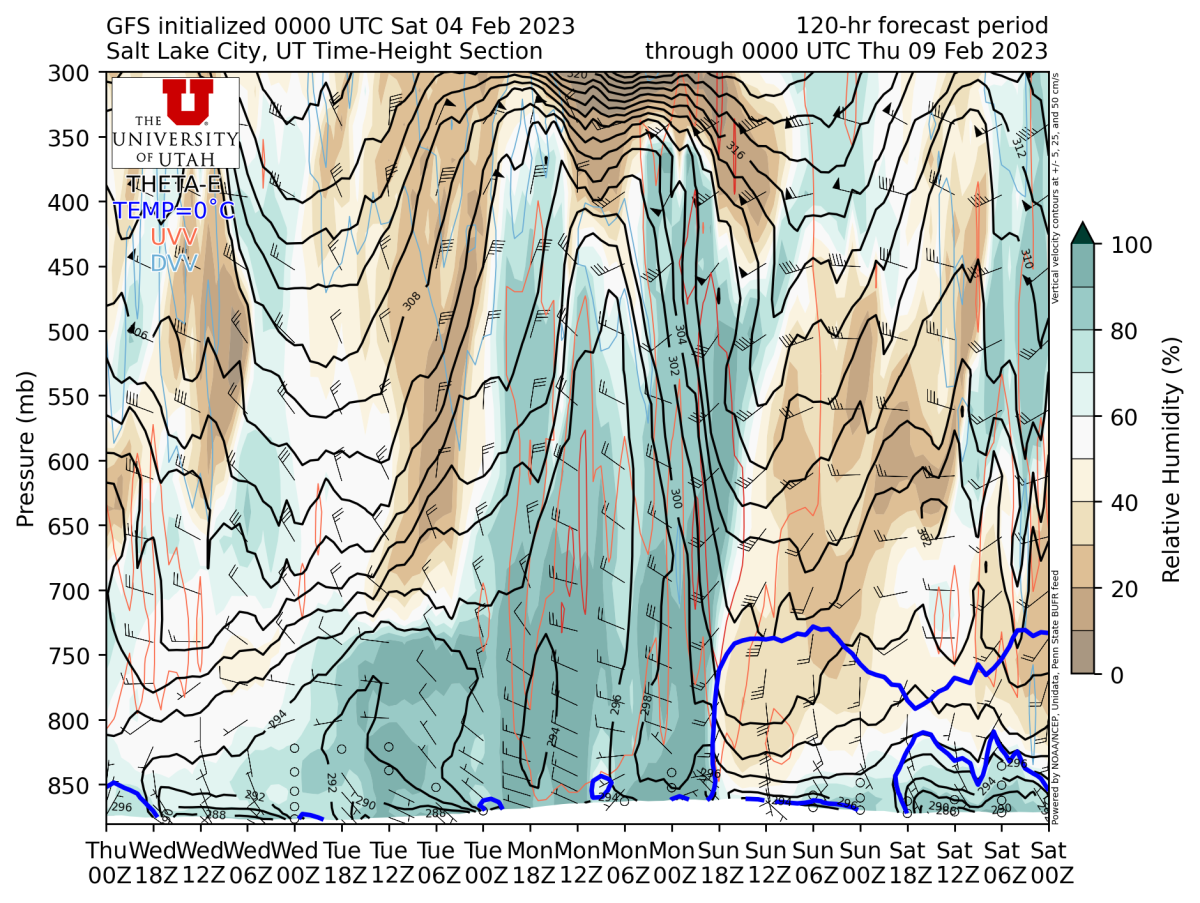
Feel free to skip to the forecast totals, but here’s a quick explainer on how to read this plot for the curious. These are probably my favorite chart to look at to pick which days I ski because they show you pretty much everything you need to know in one single image. On the x-axis, time passes from right to left. It’s noted in Zulu time, which is just London’s timezone, meteorologists use this as the standard for some reason. It’s 7 hours ahead of SLC time.
On the y, height increases as you go up. It’s denoted by pressure, which decreases as you move up in the atmosphere. For reference, the Salt Lake Valley is close to 870 mb, the top of the Wasatch is somewhere around 700 mb, and commercial planes cruise up around 300 mb.
What I look for on these is simply the overlap of three ingredients: moisture, favorable flow direction, and weak stability. Moisture is denoted by the deeper shades of green, which we have plenty of between midday Sunday and Monday afternoon. The little arrows show the wind direction, and we’re looking for anything between west-northwest and north-northwest for the Cottonwoods. Other areas have different favorable wind directions, but the Cottonwoods produce snow with mind-boggling efficiency in northwest flow regimes. The third important ingredient is weak stability, which is denoted by the black lines. When they’re vertical (or close-ish), stability is weak. When they’re horizontal, we’ve got stronger stability – bad for mountain snow.
We’ve got all three ingredients between Sunday and Monday here, and I expect periods free refills for the Cottonwoods on Monday as a result.
Snow showers will slowly taper off Monday evening. By then, expect the following storm totals:
- Alta, Snowbird, Solitude & Brighton: 10-18″
- Park City & Deer Valley: 8-14″
- Beaver, Powder Mountain, and Snowbasin: 7-13″
- Brian Head: 4-8″
- Eagle Point: 8-12″
Long Range Prospects
Other than the storm that prompted this forecast, powder prospects will be pretty limited for the next ~10ish days. There could be some snow showers on Thursday the 9th, but I’m not getting too excited about that.
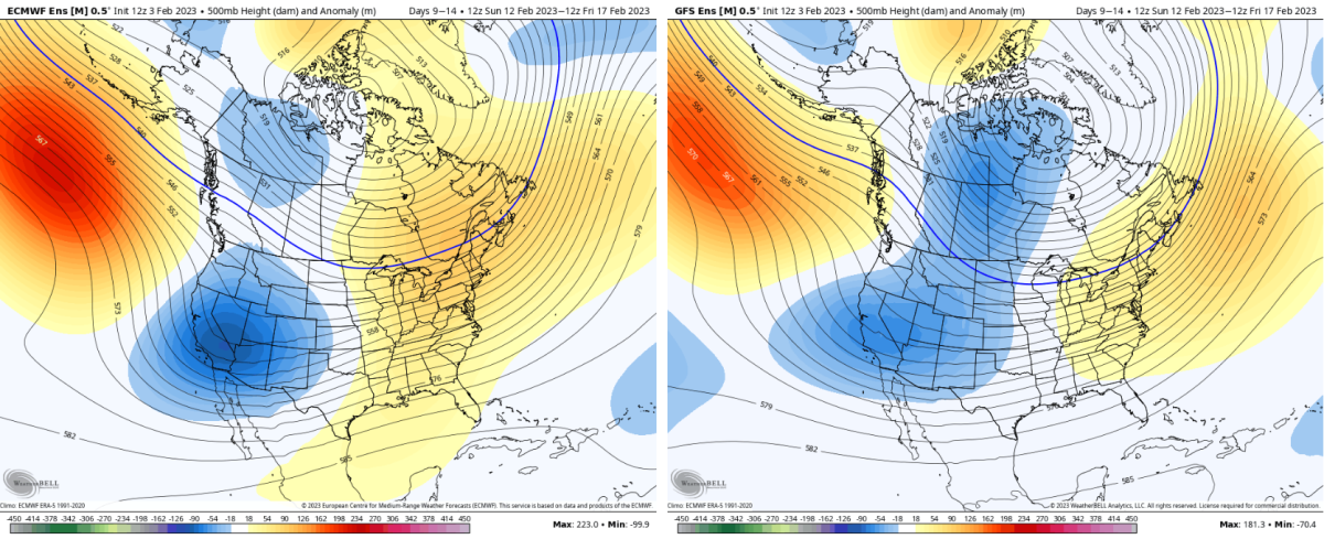
Then, around mid-month, it looks like we might see a bit of a better pattern come together. Ensembles advertise a trough developing over the West around the middle of the month, which is a promising look for snow in Utah.
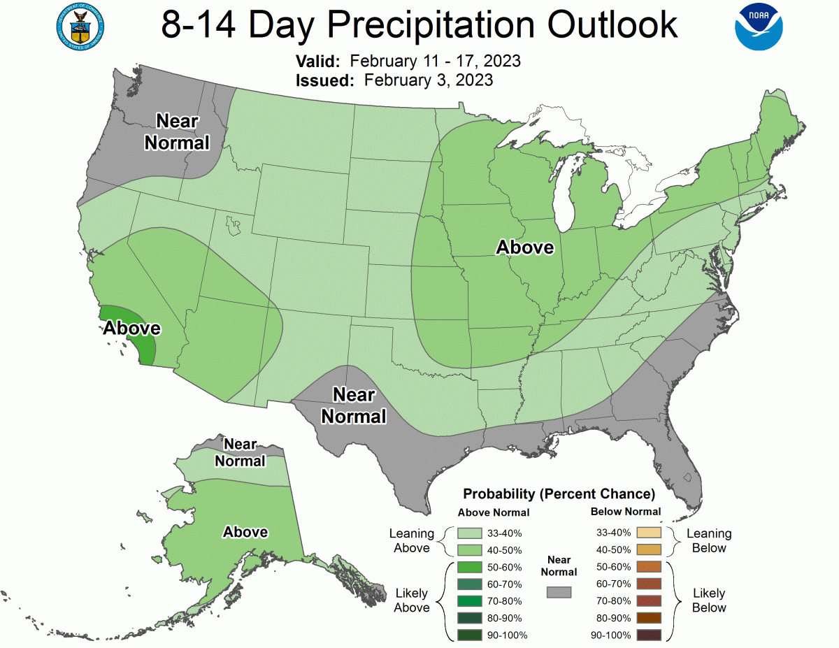
The CPC’s long-range outlook reflects this: