A series of active weather systems will bring fresh snow to the Utah mountains through the end of the week, with periods of heavy snowfall and strong winds at times. Expect snow levels to drop to many valley floors during the first system, followed by daily mountain snow showers that persist through Saturday. By late weekend, conditions will turn drier and milder, setting the stage for a pleasant finish to the period. Overall, skiers and riders should find multiple opportunities for fresh turns, especially in the mid to higher elevations.
Strong southerly winds will mark the onset of unsettled weather on Monday, particularly in southern Utah. Gusts could exceed 50 mph in exposed terrain by afternoon, which may impact upper-mountain experiences. A cold front arrives late Monday afternoon into evening, rapidly lowering snow levels to many valley floors by midnight and delivering moderate to heavy mountain snowfall. Snow quality should quickly improve overnight as colder air filters in, supported by snow-to-liquid ratios in the 12–15:1 range at some resorts.
The core of the Monday night–Tuesday storm will maintain steady mountain snowfall across northern and central Utah. Heavier bursts are likely along the I-15 corridor from Nephi to Beaver, with storms continuing through midday Tuesday. In the northern Wasatch and the Cottonwoods, snow ratios may climb above 15:1 by Tuesday night, promoting lighter, drier powder on the slopes. Accumulations will gradually taper off late Tuesday, though lingering snow showers will keep terrain refreshed into Wednesday morning.
A secondary wave on Wednesday will add additional mountain snow, especially in the southern Utah ranges. Around 4–8 inches could accumulate in higher elevations from midweek into Thursday, with smaller totals further north. Daily afternoon snow showers will persist through Friday and into Saturday, although amounts will trend lighter each day. With continued cool temperatures, snow quality should remain reasonably good, especially above mid-mountain elevations.
By Saturday, leftover showers will taper off, setting the stage for a sunnier and milder pattern by Sunday. Temperatures will rebound to near seasonal norms, favoring comfortable conditions on the slopes. Though a widespread warmup is expected, the snowpack at upper elevations should remain in decent shape. Looking beyond the weekend, no major signals point to a drastic shift, suggesting a typical spring pattern with periodic mild spells and the possibility of weaker disturbances down the road.
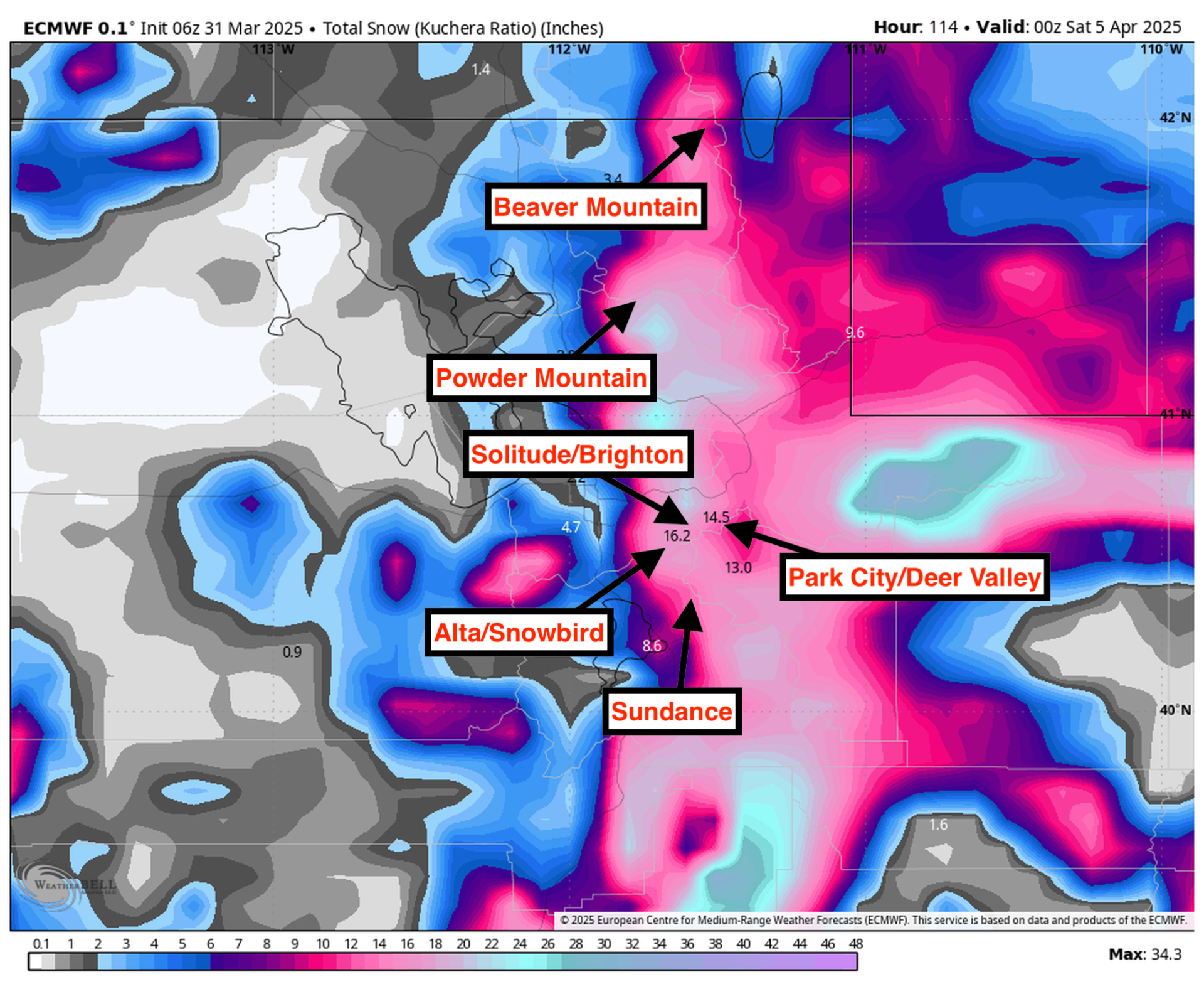
Resort Forecast Totals
- Alta/Snowbird – 11″-16″ Mon (03/31) – Wed night (04/02)
- Solitude/Brighton – 10″-15″ Mon (03/31) – Wed night (04/02)
- Eagle Point – 10″-15″ Mon night (03/31) – Fri (04/04)
- Powder Mountain – 8″-12″ Mon (03/31) – Wed night (04/02)
- Park City/Deer Valley – 7″-10″ Mon (03/31) – Wed night (04/02)
- Beaver Mountain – 4″-6″ Mon (03/31) – Tue night (04/01)