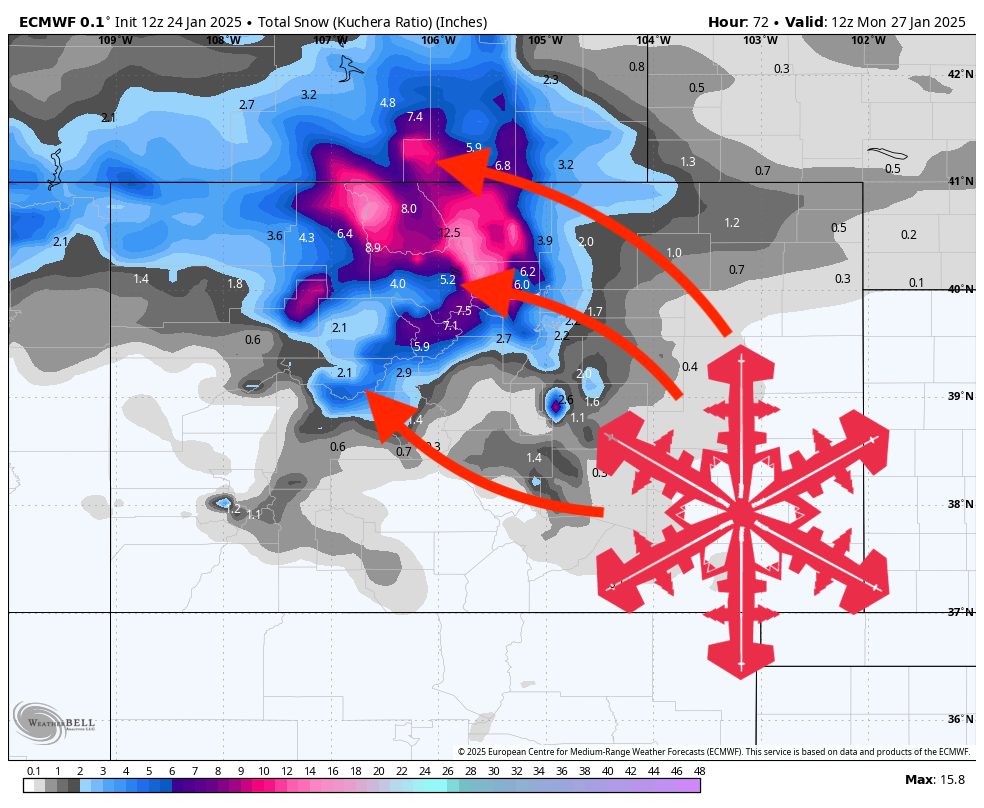
A fresh round of snowfall moves into Colorado’s northern mountains on Friday night and through the weekend, with moderate accumulations and lower amounts farther south. A lull arrives by Sunday, though a weaker system may graze southern mountains early next week. Another wave midweek could favor southwestern resorts with light to moderate snow, while other areas see minimal precipitation. Overall, temperatures hover around normal through the extended period, slightly milder east and occasionally unsettled across the south.
Snow intensifies late Friday into Saturday across the northern and central mountains. Light to moderate accumulations are expected, mainly favoring areas north of I-70, while mountains farther south see lesser totals. Snow levels remain well below resort bases, ensuring all snow at higher elevations, and breezy conditions could accompany the more intense periods of snowfall. By Saturday night, accumulations taper off in most areas, but ongoing scattered snow showers could linger over the higher terrain.
From Saturday night into Sunday, moisture decreases across much of Colorado, resulting in a lull in new snowfall. The highest elevations along the northern ranges may still see light snow showers, but additional accumulations should be minimal. Meanwhile, a weak system moves toward the Four Corners early next week, bringing the potential for modest snowfall amounts over the San Juans and southern resorts. With only modest moisture present, these southern mountains could pick up a few inches of new snow through Tuesday, while the rest of the state sees very little fresh accumulation.
Looking into midweek, another disturbance could brush southwestern Colorado, potentially boosting snow totals at resorts like Monarch and Wolf Creek. Snow levels remain comfortably below resort elevations, but the overall moisture fetch appears limited, so accumulations should stay moderate. Farther north, the midweek period looks mostly quiet, though occasional flurries can’t be ruled out in the higher peaks. In the extended outlook, temperatures may trend near to slightly above average, especially across the eastern plains, while southwestern areas carry chances for additional light snowfall.
Resort Forecast Totals
- Steamboat – 5″–10” Fri Night (01/24) – Sun Night (01/26)
- Winter Park – 4″–9” Fri Night (01/24) – Sat Night (01/25)
- Loveland/Arapahoe Basin – 4″–7” Fri Night (01/24) – Sat Night (01/25)
- Vail/Beaver Creek – 3″–6” Fri Night (01/24) – Sat Night (01/25)
- Wolf Creek – 2″–6” total (0–1” Tue Day (01/28) + 2″–5” Wed Day (01/29) – Thu Night (01/30))
- Copper Mountain/Breckenridge – 2″–5” Fri Night (01/24) – Sat Night (01/25)
- Monarch – 1″–4” Wed Day (01/29) – Thu Night (01/30)
- Snowmass – 0″–2” Sat Night (01/25)
- Crested Butte – 0″–1” Sat Night (01/25)
- Telluride – 0″–1” Tues Day (01/28)