This forecast was created at 8:30 a.m. PST on Friday, March 28, 2025.
California is back in prime form this week with multiple storms lined up, delivering feet of new snow across the Sierra through Friday—highlighted by the Monday–Wednesday window when totals will surge and snow quality will be excellent thanks to consistently cold temperatures and high snow-to-liquid ratios. After a quick-hitting wave Friday, high pressure briefly builds Saturday, but a parade of increasingly potent systems follows from Sunday onward, tapping deep moisture, sub-5,500 foot snow levels, and strong dynamics. The Tahoe Basin and Mammoth both see significant snowfall, with widespread totals of 2 to 4 feet and localized amounts pushing higher. Snow quality improves markedly by Monday night, peaking midweek with SLRs in the 12–15:1 range. A colder extended outlook and favorable precipitation signals suggest the potential for even more powder into mid-April.
The tail end of a modest system brushes the northern Sierra Friday, dropping a few inches before clearing out. Snow levels will hover around 5,000 to 5,500 feet, bringing light accumulations to the higher resorts. Expect 1–3 inches of new snow across much of the Tahoe Basin, with light, fair-quality snow in the 10:1 to 12:1 range. Skies begin clearing Friday night as ridging briefly builds, setting the stage for a stellar Saturday across the Sierra with sunny skies and light winds—perfect for storm prep or touring untouched leftovers from the morning.
Sunday ushers in the beginning of a very active week as the first in a string of storms moves in. Snow will begin during the day and increase into the night, with snow levels generally between 4,500 and 5,500 feet. By Sunday night, 3–6 inches will accumulate at many upper-mountain locations. Winds increase substantially by late Sunday, and gusts will remain strong through Monday, especially over ridgelines, where gusts may exceed 90 mph. Snow ratios remain modest to start, in the 7–9:1 range, so snow will initially be on the denser side. However, snow intensifies significantly Monday into Monday night, with 6–12 inches possible during that span alone. Snow quality improves markedly by Monday night as colder air arrives and SLRs rise into the 12–15:1 range.
The Tuesday–Wednesday period features the strongest storm of the week and the best snow quality. A deeper system arrives late Tuesday with continued heavy snowfall, especially Tuesday night into Wednesday. Accumulations of 10–20+ inches during this period are likely for favored Sierra resorts, and snow levels will fall as low as 3,000 feet early Tuesday, staying cold enough to support low-density snow throughout. Ridgetop winds remain strong but should begin to ease slightly by Wednesday. SLRs peak in the 13–15:1 range midweek, so this is likely to be the fluffiest and driest snow of the forecast period. Resorts like Kirkwood and Sugar Bowl could see storm totals nearing or exceeding 3 feet by Wednesday night.
A final weaker wave Thursday into Friday brings diminishing but still notable snowfall totals to the region. Additional accumulations of 2–6 inches are expected with this system, with snow quality remaining decent due to continued cool temperatures and SLRs in the 11–13:1 range. Winds decrease and snowfall becomes more intermittent, allowing for occasional clearing breaks. Overall, the Sunday–Friday storm sequence will deliver significant snowfall across the Sierra, with multiple feet of accumulation at higher elevations and a strong refresh for all major resorts. Looking ahead, both the 6–10 and 8–14 day outlooks favor continued below-normal temperatures and above-normal precipitation across the western U.S., including California. This supports the potential for additional systems into the second week of April, keeping the late-season powder train alive.
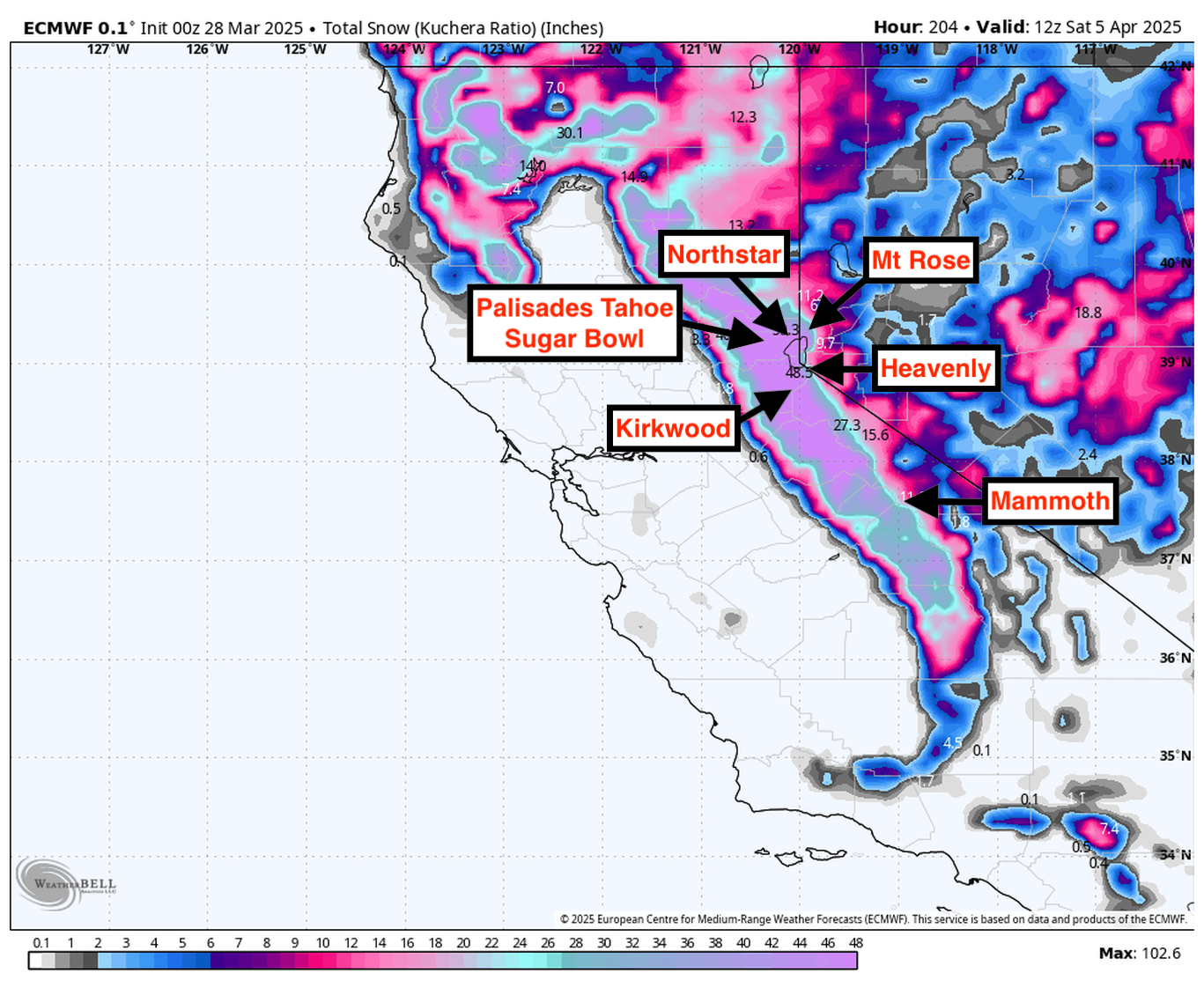
Resort Forecast Totals
- Kirkwood – 27”–48” Sat night (03/29) – Fri night (04/04)
- Palisades Tahoe – 23”–42” Sun (03/30) – Fri night (04/04)
- Sugar Bowl –21”–38” Sun (03/30) – Fri night (04/04)
- Mammoth – 20”–37” Sat night (03/29) – Fri night (04/04)
- Heavenly – 14”–26” Sun (03/30) – Fri night (04/04)
- Northstar – 13”–25” Sun (03/30) – Fri night (04/04)
- Mt Rose – 13”–24” Sun (03/30) – Fri night (04/04)