SnowBrains meteorologist Clay Malott wrote this forecast on October 14 at 1 p.m.
With winter just around the corner, the first signs are appearing in the Pacific Northwest—snow is beginning to dust the highest peaks, signaling the start of the season. This week, we’re looking at two storm systems that will bring a mix of rain and snow, with significant snowfall possible at higher elevations.
TL;DR FORECAST SUMMARY
- First Wave (Monday): Mild and warm with snow levels above 9,500 feet. Expect 0.25 to 1 inch of rain, mostly affecting British Columbia & northern Washington and pushing southward.
- Second Wave (Wednesday-Friday): Starts with rain up to 6,500 feet, but snow levels will drop steadily. Snow totals of 5-15 inches above 4,000 feet, with higher amounts at volcanic summits.
- Looking Ahead: Potential for another system arriving this weekend, though intensity and temperatures are still uncertain.
First Wave (Monday)
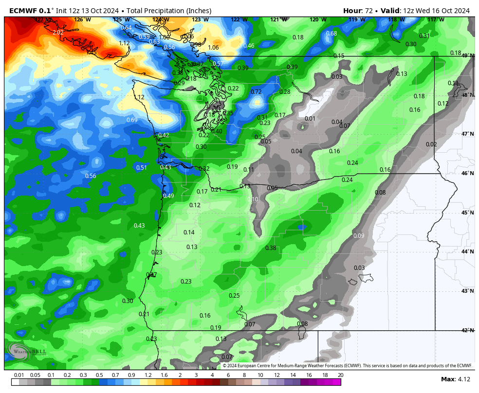
The first wave of precipitation arrives Monday morning, starting in British Columbia and gradually pushing south and east throughout the day and into the night. This initial wave will be mild and warm, with snow levels sitting above 9,500 feet—meaning most ski resorts will see rain instead of snow. Precipitation amounts are expected to be on the lighter side, ranging between 0.25 to 1 inch of rain across the region. Below is the ECMWF projected accumulated rainfall by Wednesday morning (end of the first wave):
Second Wave (Wednesday-Friday)
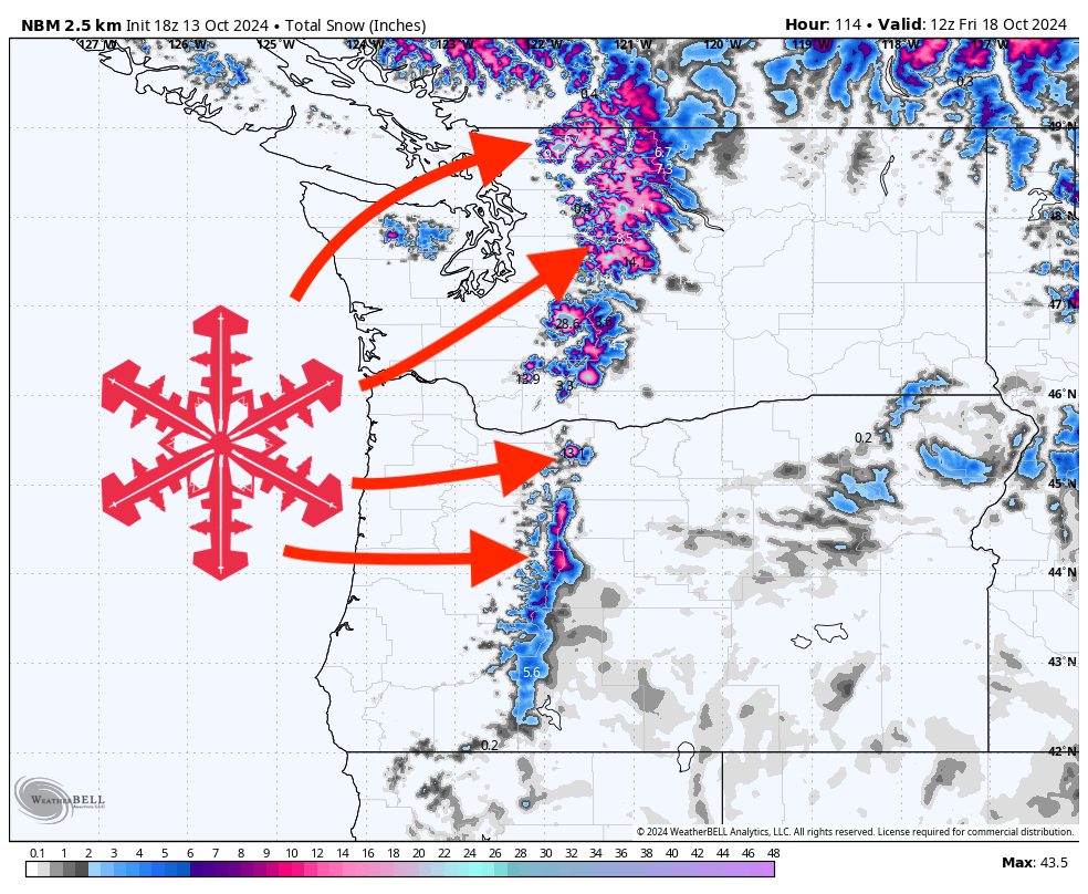
The second wave arrives hot on the heels of the first, moving in as the first wave’s precipitation diminishes on Wednesday morning. It starts off warm again, with rain falling up to 6,500 feet, but snow levels will drop steadily throughout the storm. By the time it wraps up on Friday morning, snow levels should be down to about 3,500 feet in the north around Mt. Baker and 4,500 feet in the south near Mt. Bachelor.
Snow totals will range from 5 to 15 inches in the mountains above 4,000 feet, with a fairly even distribution from north to south. However, the highest totals are likely for the high peaks of the North Cascades in Washington. By Friday evening, here are projected totals at mid-mountain elevations of several ski areas in the region:
- Mt. Baker: 8-12″
- Stevens Pass: 4-8″
- Alpental: 4-8″
- Crystal Mountain: 2-5″
- Mt. Hood Timberline: 8-12″
- Mt. Bachelor: 3-6″
The biggest limiter for snow accumulation will be the mild temperatures, resulting in rain and wet, heavy snow for much of the storm at most elevations. Localized spots without this temperature issue could see much higher totals. The summits of the volcanoes, in particular, could stack up some impressive—though mostly unverifiable—snow amounts:
- Mt. Baker: 35-45″
- Mt. Rainier: 25-35″
- Mt. Hood: 15-25″
- Mt. Bachelor: 5-15″
Looking Ahead
Another system could roll in this weekend, starting Friday night. Weather models, such as GFS and ECMWF, are still not in agreement on precipitation intensity or temperature, so it’s too early to forecast totals. Keep an eye on it as the weekend approaches—there could be more snow on the way.