The National Oceanic and Atmospheric Association (NOAA) has shared on its ENSO blog that a weak La Niña, the cooler phase of the El Niño-Southern Oscillation (ENSO), is expected to develop this winter, shifting North America’s precipitation patterns. Contributors he ENSO blog are, amongst others, Michelle L’Heureux (NOAA Climate Prediction Center), Emily Becker (University of Miami/CIMAS), Nat Johnson (NOAA Geophysical Fluid Dynamics Laboratory), Tom DiLiberto (NOAA Office of Communications), and Rebecca Lindsey (contractor to NOAA Climate Program Office). While ENSO is the most reliable indicator of winter precipitation variability in the United States, the emerging La Niña is forecasted to have a limited intensity, raising questions about its impact on seasonal weather.
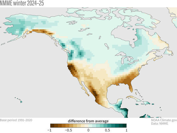
The North American Multi-Model Ensemble (NMME) paints a classic La Niña scenario: drier conditions across the southern U.S. and Mexico, with wetter forecasts for the Pacific Northwest, Ohio Valley, and Upper Mississippi regions. These projections mirror NOAA’s Winter 2024-25 Precipitation Outlook and are strikingly different from last year’s El Niño-driven forecast.
Curiously, despite its predicted weakness, this La Niña’s precipitation anomalies are stronger than last year’s El Niño—a surprising outcome given historical ENSO-precipitation relationships. Quantitative analysis confirms the anomaly’s strength is the sixth highest in the 34-year NMME record, even though ENSO’s forecasted strength ranks only 18th.

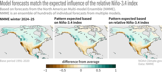
One explanation lies in the relative cooling of the Niño-3.4 region compared to an unusually warm tropical ocean. This disparity may amplify La Niña-like impacts. Adjusting the Niño-3.4 index to account for broader tropical warming—a method known as the Relative Oceanic Niño Index (RONI)—better aligns forecasts with observed precipitation patterns. This approach highlights the influence of relative cooling in driving precipitation anomalies, even under weak ENSO conditions.
The enhanced precipitation anomalies suggest the tropical Pacific’s broader warmth could magnify La Niña-like effects. Even if ENSO remains neutral, these dynamics might still push North America toward a La Niña-style winter. As the climate evolves, such patterns underscore the importance of refining ENSO metrics to capture the complex interplay of global ocean temperatures and their impacts on seasonal weather.
For a more detailed analysis of the ENSO patterns developing and the full blog, visit the ENSO blog at the climate.gov website.