Brought to you by The Weather Company
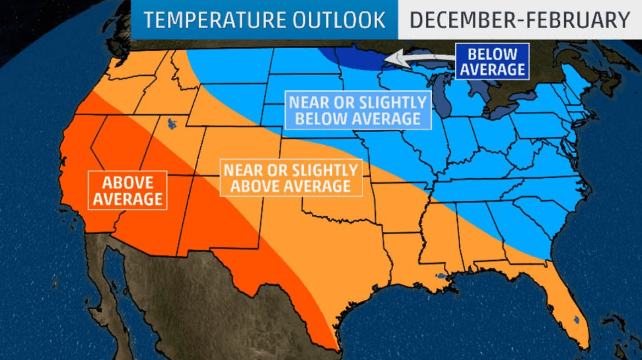
A warmer than usual winter is forecast for much of the southern and western United States, but the northern and eastern U.S. will be shivering, according to an updated winter outlook released Thursday by The Weather Company.
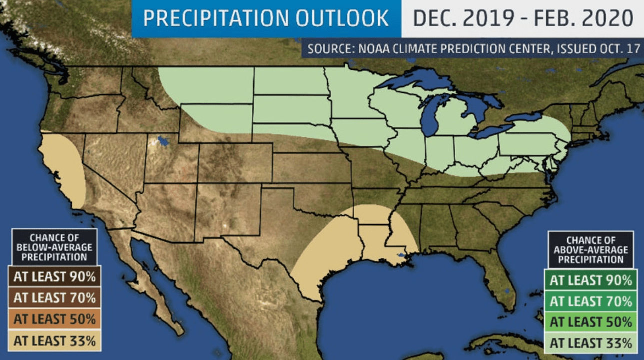
Additionally, NOAA’s winter outlook indicates that parts of the flood-weary Northern Plains and Midwest might see a wetter than average December through February.
Based on The Weather Company’s outlook, temperatures are expected to be near or above average for much of the South and West, but parts of the North and East won’t be so lucky. Temperatures there are projected to be near or below average.
Areas from southwestern Oregon into California, the Great Basin, Desert Southwest, and southwestern Texas are forecast to have warmer than average temperatures during the three-month period from December through February. Colder than average temperatures are predicted from northeastern North Dakota into northern Minnesota, far northwestern Wisconsin and the far western Upper Peninsula of Michigan.
A broad area from the Pacific Northwest to the central Rockies, Southern Plains, lower Mississippi Valley, and Gulf Coast will likely have temperatures that are near or slightly warmer than average this winter. Meanwhile, the northern Rockies, Northern Plains, Midwest, and East can expect near or slightly below average temperatures for the December-to-February period as a whole.
Dr. Todd Crawford, the chief meteorologist at The Weather Company, noted several factors that were considered in this winter outlook:
- Water temperatures in the tropical Pacific Ocean and their influence on the atmosphere. Expected conditions there this winter suggest a respite from the bitter cold in December before colder than average conditions return in January and February, especially in the Northern Plains and Great Lakes.
- “The blob” of warmer than average temperatures in the northeastern Pacific Ocean, which favors a steady stream of cold air into Canada and parts of the northern U.S., particularly in January and February, and correlates with warmer winters in the western U.S. and Alaska.
- Solar activity linked to the sun’s regular 11-year cycle will likely bottom out in 2020. The resulting effects on the upper atmosphere increase the odds of a blocking pattern, suggesting colder winters in the East and warmer ones in the West.
- A lack of Arctic sea ice, which is one factor favoring warmer temperatures in the East.
- Computer forecast models that have trended notably colder than previous runs in the eastern U.S., increasing the confidence of a colder than average winter for the northern and eastern states.
Here’s a closer look at how the forecast evolves over the winter (December through February).
December
- The first month of winter will likely feel different than the last two months of the season.
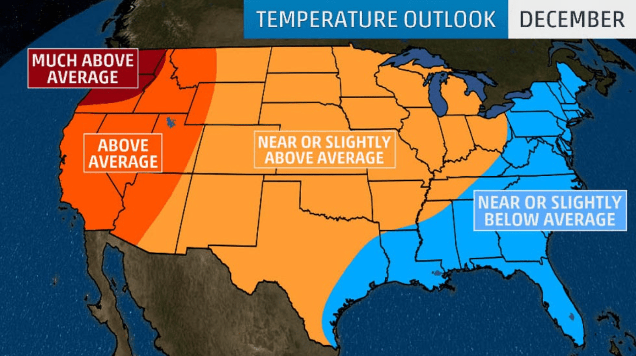
- Warmer than average temperatures are forecast across the West in December, with much above average warmth predicted in the Pacific Northwest.
- Most of the Rockies, Plains and Midwest can expect near or slightly above average temperatures.
- The East and Gulf coasts, however, are predicted to have near or slightly below average temperatures in December.
January
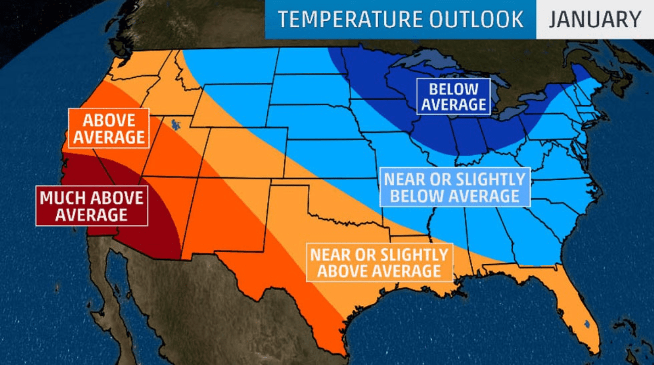
- Colder than average temperatures will return to the upper Midwest and Great Lakes while expanding into parts of far northern New England in January.
- Areas from the northern Rockies into the Northern and Central Plains, mid-Mississippi Valley, Southeast and much of the Northeast may see near or slightly colder than average temperatures.
- Meanwhile, temperatures are expected to be much above average from Central and Southern California into southern Nevada and parts of Arizona. Above-average temperatures will likely extend from southern Oregon and Northern California into the Great Basin, the southern Rockies, and western and southern Texas.
- Near or slightly above average temperatures are predicted from the Northwest into the central Rockies, Southern Plains, Gulf Coast and Florida.
February
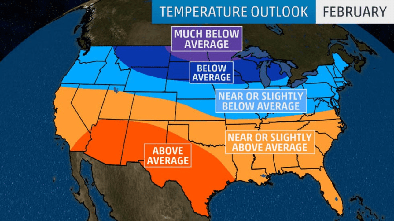
- February may have the coldest temperatures of the winter across parts of the North.
- Below-average temperatures are likely from the northern Rockies into the Northern Plains, upper Midwest and northern Great Lakes. The most anomalous cold is expected across North Dakota, northern Minnesota, far northwestern Wisconsin and the far western Upper Peninsula of Michigan.
- Warmer than average temperatures are predicted from southeastern California through the Desert Southwest and much of Texas.
- Temperatures will generally be near, slightly above or slightly below average between those areas.
NOAA’s Winter Outlook
NOAA released its winter outlook in mid-October and highlighted an area from the northern Rockies and Northern Plains into parts of the Midwest, mid-Atlantic and Northeast as having an above-average chance of receiving more precipitation than usual this winter. This includes areas of the Northern Plains and Midwest that have already experienced well above average precipitation and record flooding this year.
Wetter than average conditions are also likely in Alaska and Hawaii.
However, conditions may be drier than average this winter in parts of Northern and Central California, as well as from southern and eastern Texas into the lower Mississippi Valley. Drought could develop over the next few months in parts of Central California, where most rainfall occurs in the cool season.
Regarding its temperature outlook, NOAA expects areas from the Northeast through the South and into the West to have a higher chance of above-average temperatures from December to February.
The best chance for warmer than average temperatures, however, will be in Alaska and Hawaii.
Portions of the Northern Plains into the Midwest have equal chances of near, above or below-average temperatures.
“Without either El Niño or La Niña conditions, short-term climate patterns, like the Arctic Oscillation, will drive winter weather and could result in large swings in temperature and precipitation,” said Mike Halpert, the deputy director of NOAA’s Climate Prediction Center.