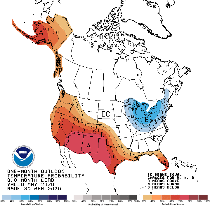
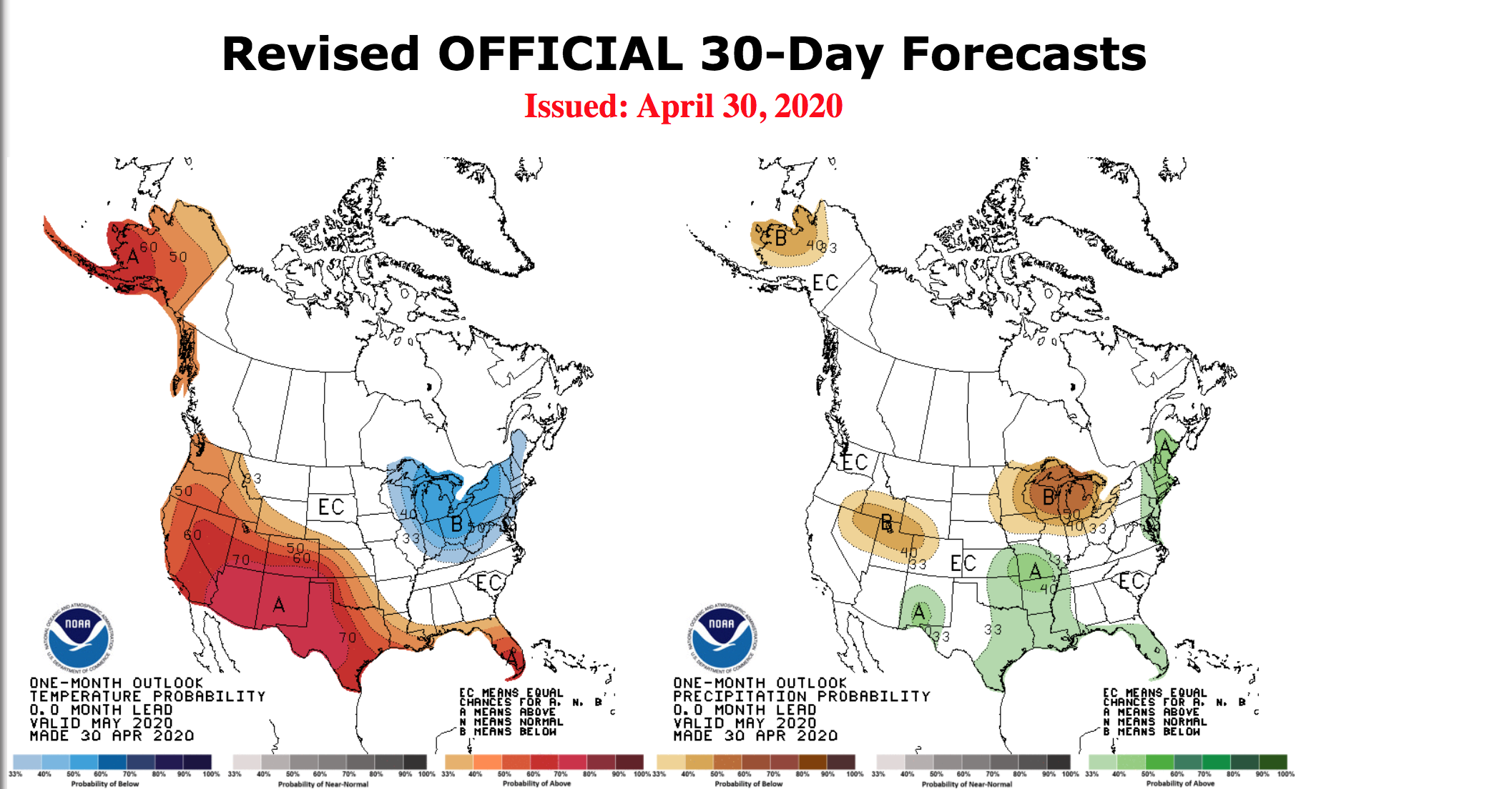
The Climate Prediction Center just released their monthly weather outlook for May. According to the CPC, May sees the best chances for a warmer than average month across the Southwest, while odds tilt cooler across the Great Lakes.
The weather outlook summary for May 2020 by the CPC is attached below:
30-DAY OUTLOOK DISCUSSION FOR MAY 2020

The updated monthly temperature and precipitation outlooks for May 2020 are
based on the latest dynamical model guidance, WPC temperature and precipitation
forecasts during the first week of the month, the CPC 6-10/8-14 day temperature
and precipitation outlooks, and climate linkages to current soil moisture. The
enhanced phase of the Madden-Julian Oscillation (MJO) propagated east across
Africa and the Indian Ocean during mid to late April. Despite the coherent,
ongoing MJO and the likelihood of continued eastward propagation through early
May, it is unclear how much influence the MJO will have on the mid-latitude
circulation pattern. If the MJO continues to shift eastward over the Western
Hemisphere, the large-scale environment would become favorable for tropical
cyclone (TC) development in the East Pacific later in May and perhaps the Gulf
of Mexico heading into June. Please refer to CPC’s Global Tropics Hazards for
updates on the MJO along with TC development forecasts.

Dynamical model forecasts are in excellent agreement for this time of year and
feature a high amplitude ridge (trough) over western (eastern) North America
during the first two weeks of May. This highly amplified ridge aloft increases
chances of above normal temperatures throughout the West extending to the
central and southern Great Plains. The largest probabilities (70 percent or
more) of above normal temperatures are forecast across the Southwest due to
anomalous heat likely to begin the month and also long-term trends . Rapidly
drying topsoil supports those large probabilities extending east to the
southern High Plains. An area of increased chances of below normal temperatures
was added to the Great Lakes, eastern Corn Belt, and parts of the Northeast due
to a persistent and highly amplified upper-level trough early in the month.
Week 3-4 tools such as the CFS and ECMWF (initialized on Apr 27) suggest that
temperatures across these areas would moderate or even transition to
warmer-than-normal during the latter half of May. Equal chances of below, near,
or above normal temperatures extend from the northern Great Plains southeast to
the southern Appalachians and Carolinas where temperatures are expected to be
highly variable during the month. Although the amplified upper-level trough
over eastern North America is expected to result in a period of near or below
normal temperatures across Florida during early May, above normal temperatures
remain the most likely outcome for the entire month, especially the southern
half of the Peninsula.

The high amplitude ridge/trough pattern over North America, forecast during
early May, is a complicating factor in the revised precipitation outlook. This
longwave pattern is a relatively dry one for the CONUS, while the outlook
(released on April 16) featured a broad area with elevated probabilities of
above normal precipitation throughout much of the Great Plains, Mississippi
Valley, and Southeast. Since there is likely to be at least a week of mostly
dry weather across the northern half of the Great Plains and parts of the
Southeast, the coverage of elevated probabilities of above normal precipitation
was reduced. The Weeks 3-4 tools (as of Apr 27) along with the CFS monthly
continue to support either near or above normal precipitation across the Gulf
Coast States. The slightly elevated chances of above normal precipitation,
centered across the Ozarks to the middle Mississippi Valley, is associated with
predicted rainfall at the beginning of the month. During the second week of
May, model guidance continues to trend towards a wetter solution from the upper
Rio Grande Valley north into New Mexico as return flow from the western Gulf
spreads northwest. Given that these areas are relatively dry this time of year,
above normal precipitation is slightly favored for parts of the Big Bend of
Texas and New Mexico. A wet start to the month and many of the precipitation
tools support increased chances of above normal precipitation across the
Northeast. Given that the first half of the month is likely to be quite dry
with anomalous northerly flow, below normal precipitation is most likely across
the Great Lakes and northwest Corn Belt. To the north of the dry climatological
areas of the Southwest, below normal precipitation is favored across the Great
Basin due in part to the persistent, upper-level ridging early in the month.

Although near to below normal temperatures are forecast to prevail across
Alaska at the beginning of May, the high amplitude ridge is likely to result in
the development of above normal temperatures by the second week of the month.
Once this upper-level ridge establishes itself, it is expected to continue
through at least mid-May. This persistent ridge aloft and good agreement among
Weeks 3-4 tools support increased chances of above normal temperatures across
Alaska. This evolving longwave pattern also elevates probabilities of below
normal precipitation across western mainland Alaska.
What about Missouri, Saint Louis?