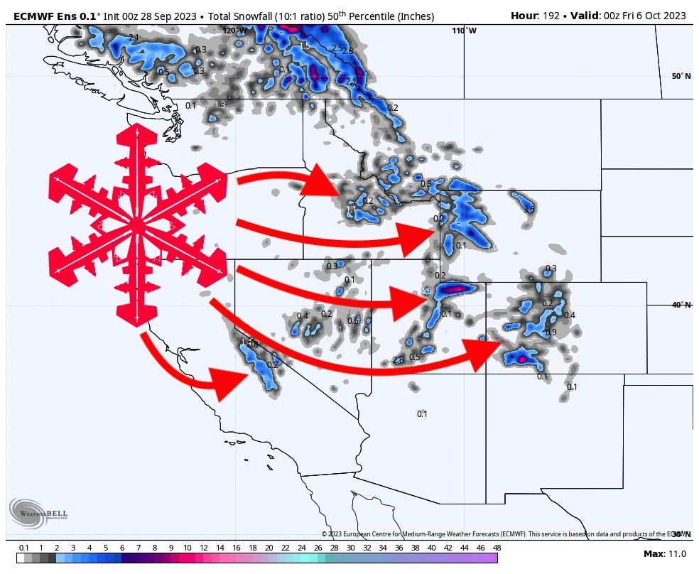
The first major trough of the season will move through the Western US late this week, weekend, and into next week, bringing unseasonably cold temperatures, moisture, and most importantly, snowfall. California, Nevada, Utah, Idaho, Montana, Wyoming, and Colorado will all see snowfall from this system, with the highest totals in CA, UT, WY, and CO.
Moisture arrives on Friday afternoon, starting in Northern California and working south. Snowfall will work its way further south and east overnight and fill into Nevada, Idaho, and Montana by morning. The storm will progress east, and by Sunday morning, should be delivering good moisture and lift for conducive snowfall over Utah, Idaho, Montana, Wyoming, and Colorado, where it will linger for several days and bring additional totals.
These early-season storms are difficult to forecast since they are dynamic and feature borderline temperatures for many elevations. Below, outline what I see as realistic totals for each major region.
California
The models have backed off quite a bit on California snowfall from earlier in the week, but this should still be a nice early-season storm. Most of the accumulation will be in the central and southern Sierra due to the elevation boost compared to the Tahoe region; snow levels will hang around 8,500 feet (plus or minus a few hundred feet) for most of the precipitation period.
In terms of totals, I see fairly widespread 3-6 inch totals above 8,500 feet, with higher elevations in the central and southern Sierra receiving a foot or more.
Utah
The two major areas to watch here are the Wasatch and Unita mountains. The Unitas have a bit of an elevation boost over the Wasatch and thus will likely pick up more snowfall when it’s all said and done. Snow levels will hang around 9,000-9,500 feet.
I’m looking for at least 3+ inches above 9,000 feet and as much as 8-12″ for higher elevations in Utah.
Colorado
The models are quite split on Colorado. The European model is keeping the moisture into CO full-force, while the American and Canadian models are keeping the moisture skirting mainly to the north and missing southern CO. The models are in fairly good agreement about temperatures, keeping snow levels around 10,000 feet.
If the European solution pans out, we’re looking at major totals for the San Juans: widespread 4+ inch totals above 10,000 feet with local maxima easily exceeding a foot. Otherwise, things will stay fairly dry down south and likely bring only a few inches. The model confidence is much better in central and northern Colorado, with widespread 2-6″ totals and up to 8-12″ in the higher elevations of the western Elks and the Flat Tops.
If I had to say, I’d say the American and Canadian models will drift toward the European solution and bring more major accumulations to the San Juans.
Looking ahead, high pressure will build over the West and keep things high and dry for the foreseeable future. This doesn’t mean no snow, but it’s looking like Western US snow prospects will be limited at best for the first two weeks of October. Long-range models are indicating that snowfall chances could make an earnest return in the third week of October, but of course, that’s extremely far out, and we don’t yet have a great idea of what will pan out. Stay tuned!
