Alaska gets a ton of snow. Possibly the most snow on Earth. Why Does Alaska get so much snow?
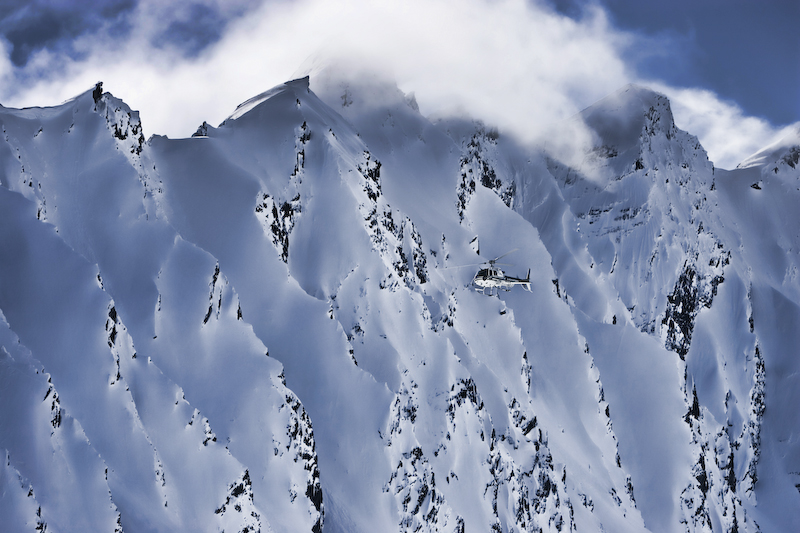
It’s an important question especially since Alaska is one of the snowiest places on Earth and holds some of the best terrain on Earth. Specifically the Chugach Range of southern Alaska. The pros flock there every March and April to prove themselves and deliver stunning footage of the best skiing and riding in the world.

Why does Alaska get so much snow?
Why do they most likely get more snow than anywhere else on Earth? (we only say most likely as there just aren’t many measurements in Alaska. No one is out in the middle of the Chugach or on the Bagley Icefild or on the Juneau Icefield taking measurements to confirm the insane amount of snow that falls there.)
The answer is an interesting combination that you need to see to understand what keeps the Alaskan snow machine firing:
Polar Jet Stream + Aleutian Low + Positive PDO
=
Big Snow in Alaska
(PDO is a pattern of ocean-atmosphere climate variability that when positive shows an increase in rain and snow in Alaska, when it’s positive, AK is 3x more likely to see low pressure storms)
In it’s most basic form, this system is pretty simple:
A semi-permanent low pressure center called the Aleutian Low gathers storms, the Polar Jet Stream consistently blows those storms into Alaska and a Positive PDO leads to more storms showing up in the Aleutian Low in Alaska. The Polar Jet Stream and the Aleutian Low define the storm track for the Alaska region.
Ok, now lets definite these three important terms:
Aleutian Low

Aleutian Low = a semi-permanent low pressure center located near the Aleutian Islands of AK during the winter. It is one of the main centers of action in the atmospheric circulation of the Northern Hemisphere. Low pressure = storms.
***
Polar Jet Stream


Polar Jet Stream = belt of powerful upper-level winds that sits at mid-latitudes (Alaska). The polar jet streams blow faster than the subtropical jet stream we are used to in the Lower 48. Most large winter storm systems form and move along the polar jet stream, so the position and strength of the stream dramatically influence Alaskan storm patterns.
***
Pacific Decadal Oscillation (PDO)

Pacific Decadal Oscillation = a robust, recurring pattern of ocean-atmosphere climate variability centered over the mid-latitude Pacific basin. The PDO is detected as warm or cool surface waters in the Pacific Ocean, north of 20° N. This climate pattern affects coastal sea and continental surface air temperatures from Alaska to California.
“Bond and Harrison (2000) found that during the positive phase of the PDO, low pressure storms (also called upper-level troughs) were 3 times more likely along the 170o W meridian than ridges (high pressure)” – NOAA
** Check out the constantly spinning air in southern Alaska where the best skiing is: the Chugach Mountains. Video showing exactly how the polar jet stream works. NASA/Goddard Space Flight Center
So what does all of this mean?
It means that Alaska is situated in the perfect place to take advantage of the Aleutian Low, the Polar Jet, and a Postive PDO and receive storm after storm all winter long.

Thompson pass is the snowiest place in Alaska, recording an average of 551.5″ of snow per year. The pass also holds the Alaskan record for the most snow in a single day: 62 inches fell on December 29, 1955.
The city of Valdez, near the legendary heli skiing terrain of Thompson Pass, averages 85 snow days per year and 326″ of snowfall – and it’s at sea level…

Alyeska Ski Resort, 40 miles outside of Anchorage, is the snowiest ski resort in North America averaging 650″ of snowfall per year.
Alyeska lies 27 miles outside of Anchorage, and consistently gets some of the most snow out of any ski resort in the USA.
Alyeska is currently sitting on a 96″ base, thanks to the 299″ of snow that they’re already received this season.

Alyeska Ski Resort is certainly no stranger to powder. In the 2011 – 2012 season, Alyeska got a whopping 978″ of snowfall.
Seriously – check out these ridiculous annual snowfall totals:
| 2014-2015 | 478″ |
| 2013-2014 | 476″ |
| 2012 – 2013 | 726″ |
| 2011 – 2012 | 978″ |
| 2010 – 2011 | 515″ |
| 2009 – 2010 | 880″ |
| 2008 – 2009 | 616″ |
| 2007 – 2008 | 875″ |
| 2006 – 2007 | 668″ |
| 2005 – 2006 | 710″ |
| 2004 – 2005 | 657″ |
| 2003 – 2004 | 763″ |
| 2002 – 2003 | 557″ |
| 2001 – 2002 | 606″ |
| 2000 – 2001 | 939″ |
| 1999 – 2000 | 818″ |
Need proof?
Alyeska’s Weekly Conditions Report

Easily the largest state in the US, Alaska is 663,298 square miles, could comfortably fit the next three largest states inside its borders (CA, TX, MT), and most likely gets more snow than any other state. Alaska not only has the country’s highest point (Denali at 20,320 feet), but also the coldest temperature on record (-80 F in Prospect Creek, 1971) and technically speaking, it’s the furthest north, west, and east (think international dateline) state in the USA.


2 thoughts on “Why Does Alaska Gets So Much Snow?”