Colorado is about to get a big boost. Loveland and Arapahoe Basin have already opened for the season. This storm might help them get more terrain open for the weekend. It may also help some other ski resorts make significant steps towards opening day. We’ll have to wait and see.

It’s November, and it’s time to snow.

NOAA Denver:
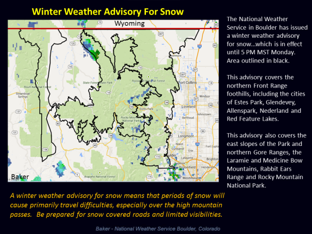
Winter Weather Advisory for the northern mountains with 4 to 8 inches of snow by Monday Afternoon. Showers will increase across the plains after midnight…with rain mixing or changing to snow along the Front Range Urban Corridor Monday morning. One to two inches of accumulation will be possible on grassy areas
NOAA Winter Storm Warning:
URGENT - WINTER WEATHER MESSAGE
NATIONAL WEATHER SERVICE GRAND JUNCTION CO
846 PM MST SUN NOV 2 2014

ELKHEAD AND PARK MOUNTAINS-GRAND AND BATTLEMENT MESAS-
GORE AND ELK MOUNTAINS/CENTRAL MOUNTAIN VALLEYS-
WEST ELK AND SAWATCH MOUNTAINS-FLATTOPS-
NORTHWEST SAN JUAN MOUNTAINS-SOUTHWEST SAN JUAN MOUNTAINS-
INCLUDING THE CITIES OF...TOPONAS...VAIL...CRESTED BUTTE...
BUFORD...OURAY...TELLURIDE...SILVERTON...RICO
846 PM MST SUN NOV 2 2014

...WINTER STORM WARNING REMAINS IN EFFECT UNTIL 5 PM MST MONDAY
ABOVE 9500 FEET...
...WINTER WEATHER ADVISORY REMAINS IN EFFECT UNTIL 5 PM MST
MONDAY BETWEEN 8000 AND 9500 FEET...

* TIMING...SNOWFALL WILL CONTINUE OVERNIGHT INTO TOMORROW MORNING.
  THE HEAVIEST SNOWFALL IS EXPECTED TONIGHT.

* SNOW ACCUMULATION...5 TO 8 INCHES ABOVE 9500 FEET. 3 TO 5
  INCHES BETWEEN 8000 AND 9500 FEET.

* SNOW LEVEL...8000 FEET.

* WINDS...WEST 10 TO 20 MPH WITH GUSTS UP TO 30 MPH.

* IMPACTS...MOUNTAIN PASSES WILL BECOME ICY AND SNOW PACKED.
  BACK COUNTRY ROADS TRAVELED BY HUNTERS AND OTHER OUTDOOR
  ENTHUSIASTS MAY BECOME IMPASSABLE DUE TO MUDDY AND ICY
  CONDITIONS.

