“Active weather pattern continues across the western U.S. this week! Here is a look at the 7 day precipitation forecast!” – NOAA, today
“Miracle March” arrived with a bang on Saturday, dropping up to 62″ of new snow on the Western USA and it will continue the next 7 days with more large snowfall totals.
NOAA is calling for 7-15″ of liquid precipitation forecast on the West Coast (see map just below video). If that all came as snow, it would equal about 7-15 feet of snowfall… Most likely it’ll be more like 4-5′ of snow, which is still epic.
So far, only New Mexico has a Snow Advisory.
VIDEO of Coming “Parade of Storms”:
A series of storms will move through California starting with a weaker system Tuesday/Wednesday. We expect stronger storms to follow!
7-15″ of liquid precipitation is forecast for the West Coast in the next 7-days. Idaho, Wyoming, Utah, New Mexico, & Montana are all forecast to see 1″ or more of liquid precipitation in the next week. image: noaa, today
Snowfall Totals in Western US Since March 1st:
CA = 62″
WA = 27″
NV = 25″
UT = 10″
OR = 9″
CO = 8″
ID = 8″
MT = 6″
WY = 5″
NM = 0″
AZ = 0″
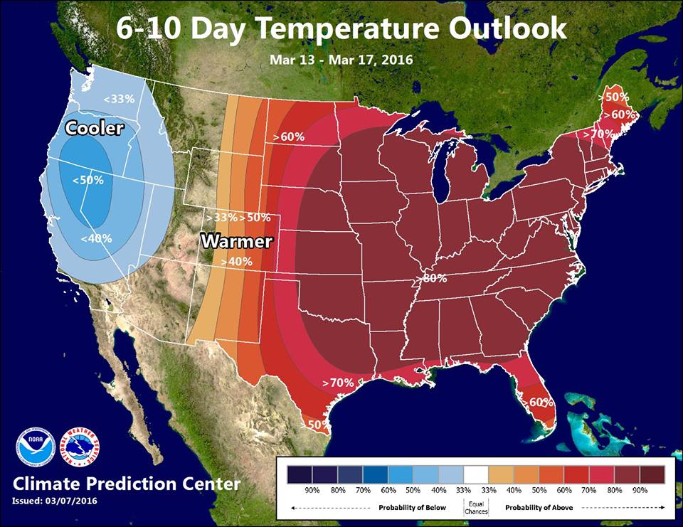
NOAA’s 6-10 day precipitation forecast is looking very good for the Western USA. Above average precip is forecast in nearly all of the Western USA. image: noaa, todayNOAA’s 6-10 day temperature forecast is looking good for the PNW. image: noaa, today
Below we outline NOAA forecasts for:
CA
PNW
Northern Rockies
CO
UT
Southwest
***
California:
“Heavier precipitation will return Thursday across much of Northern California, with plentiful amounts expected through the weekend!” – NOAA Sacramento, CA today“The next round of weather for our area is expected Thursday evening through Friday Evening. Up to a foot of snow is expected above 7000 feet in the Yosemite NP area, and several inches above 7000 feet over the Tulare county mountains.” – NOAA Hanford, CA today“More storms are on the way! Light rain will spread over northern California Tuesday and Wednesday. Wetter storms are expected Thursday into the weekend!” – NOAA Sacramento, CA today“Heavy Precipitation” forecast on the West Coast from March 10-13th. image: noaa, today
Pacific Northwest:
“Heavy rain Wednesday in the midst of a wet week in NW Oregon and SW Washington” – NOAA Portland, OR today6-14″ of snow forecast for Mt. Bachelor, OR between today and thursday. image: noaa, today“Wind & Rain & Cascades Snow this week – a reminder that Winter isn’t over yet” – NOAA Portland, OR today“The same storm that will bring windy conditions to the area on Saturday will also bring significant rain with it. The bulk of the rainfall will occur early Saturday morning through Sunday morning. Major river flooding is not a concern at this time. However, with heavy rainfall rates, small streams and creeks along with urban areas will have the potential to flood. Be ready for a wet and windy weekend!” – NOAA Medford, OR today
Northern Rockies:
“Wet. Warm. Windy. That’s the set-up we’re looking at this Thursday and Friday for north central Idaho and western Montana. Warmer temps, rising snow levels (up to 6500 feet), and rainfall will be common. The biggest impact from these elements could be rock/mud slides, and inclement backcountry conditions. Unsettled, mild conditions may persist through the weekend.” – NOAA Missoula, MT yesterdy
Colorado:
“A weak weather disturbance in northwest flow on Wednesday evening will bring light snow to the corridor from Rabbit Ears south to the west central Colorado mountains. Here are the very light amounts possible on Wednesday. After Wednesday, conditions are expected to dry out across eastern Utah and western Colorado. Stay tuned as the weather potentially becomes active again over the weekend and into early next week!” – NOAA Denver, CO today“Cool weather today…with scattered showers and isolated thunderstorms mountains and higher foothills. A few mountain and higher foothill locations will likely see a short period of heavy snow with 2 to 4 inches of accumulation. Temperatures will remain on the cool side on Wednesday…with a slight chance of showers in the mountains. Dry and warmer weather is expected across the region Thursday and Friday.” – NOAA Denver, CO today
Utah:
“9 AM Update: A quick storm will bring snow to much of Utah today into early Monday. Check out the graphic for updated frontal timing and snow accumulations.” – NOAA, SLC, UT today
Southwest:
URGENT - WINTER WEATHER MESSAGE
NATIONAL WEATHER SERVICE ALBUQUERQUE NM
1135 AM MST TUE MAR 8 2016

WEST SLOPES SANGRE DE CRISTO MOUNTAINS-
NORTHERN SANGRE DE CRISTOS ABOVE 9500 FEET/RED RIVER-
SOUTHERN SANGRE DE CRISTOS ABOVE 9500 FEET-
EAST SLOPES SANGRE DE CRISTO MOUNTAINS-

...WINTER WEATHER ADVISORY REMAINS IN EFFECT UNTIL 5 AM MST
WEDNESDAY...

* SNOW ACCUMULATIONS...3 TO 5 INCHES...EXCEPT 1 TO 3 INCHES BELOW
  8500 FEET. LOCALLY HIGHER AMOUNTS POSSIBLE ON NORTHEAST AND
  EAST FACING SLOPES OF THE PECOS WILDERNESS.

* TIMING...SNOW WILL GRADUALLY INCREASE IN COVERAGE THIS AFTERNOON
  AND CONTINUE THROUGH THE EVENING. SNOW WILL TAPER OFF DURING
  THE LATE EVENING AND OVERNIGHT HOURS.

* WINDS...NORTHEAST AND EAST AT 10 TO 20 MPH.

* SNOW LEVELS...AROUND 8500 FEET THIS AFTERNOON...THEN FALLING
  THIS EVENING. TEMPERATURES WILL BE COLD ENOUGH FOR SNOW AT ALL
  LEVELS OVERNIGHT.

* LOCAL IMPACTS...ROADS MAY BECOME SNOW PACKED AND ICY...
  ESPECIALLY OVER MOUNTAIN PASSES.
“Expect light rain and snow showers today, mainly along and south of the Mogollon Rim. Fair weather is forecast for the nw part of AZ.” – NOAA Flagstaff, AZ today“After a round of showers and cooler temperatures from a front today, warmer conditions will finish up the week.” – NOAA Albuquerque, NM today


One thought on ““Parade of Storms” To Continue in Western USA | Snow Totals Looking Huge Next 7-Days”