According to the NOAA, an impactful atmospheric river event will likely move southward along the West Coast from January 31 through February 5, bringing heavy rain and high winds to California and interior regions of the Southwest, along with heavy snow at higher elevations.
“Heads up! A potentially warm/wet system could bring periods of heavy precipitation with high snow levels around the end of the month through early February. A lot is still uncertain with this system, so stay tuned for updates!”
11 atmospheric rivers dumped over fifty feet of snow and record rainfall on California last season, with many resorts breaking all-time snowfall records.
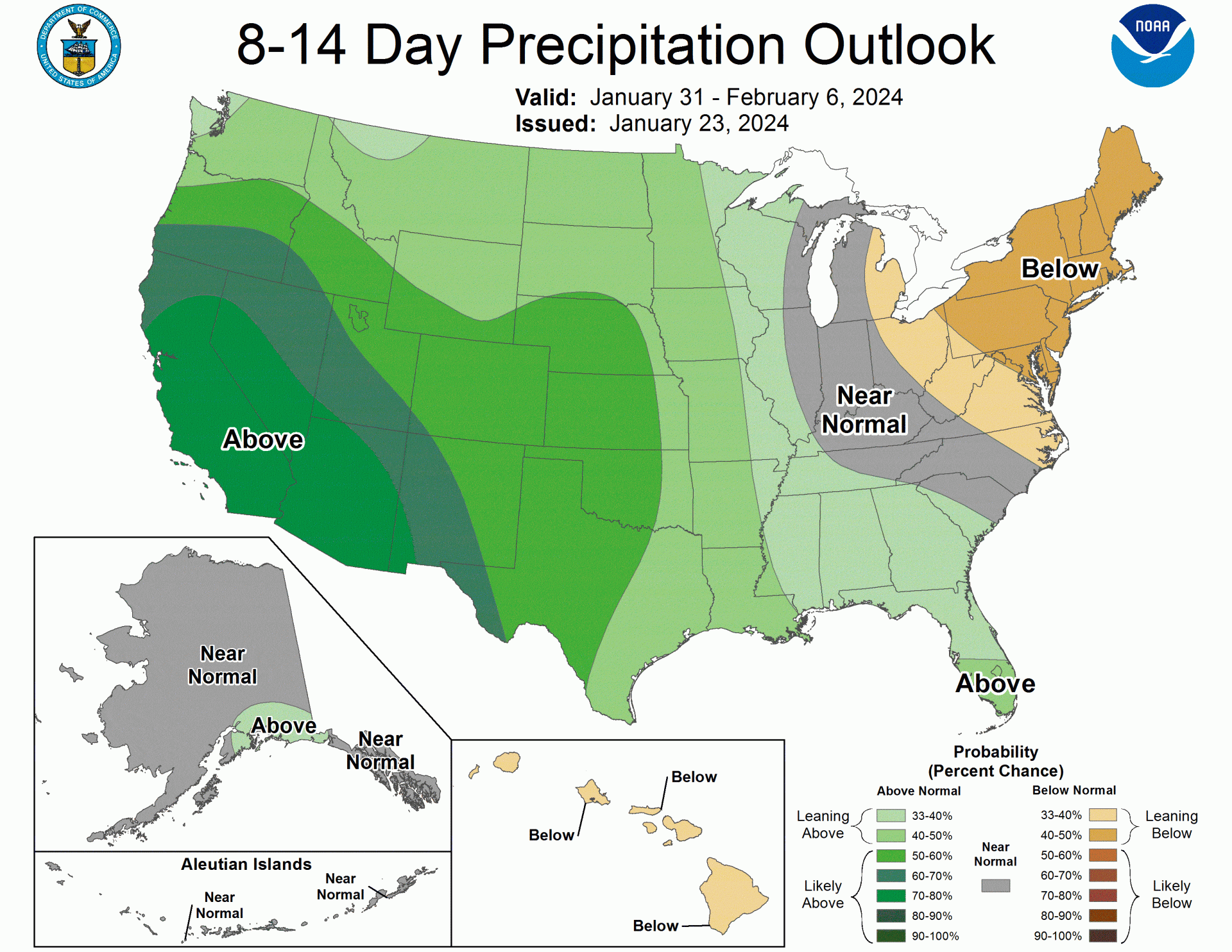
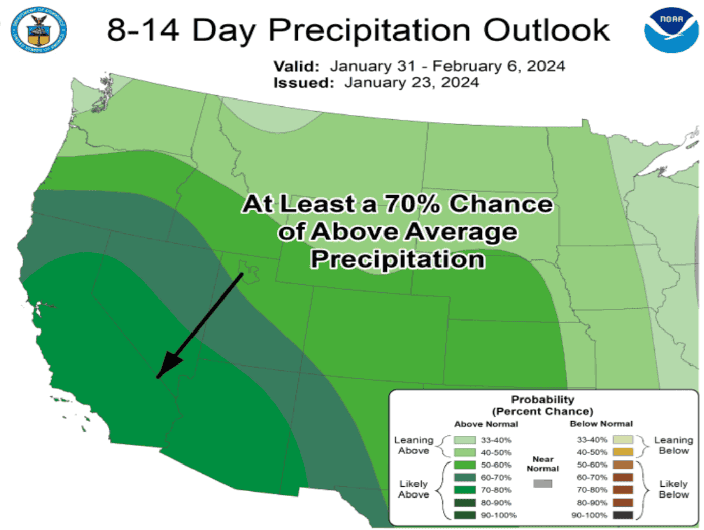
There is a 60 to 80% chance of above-normal precipitation along the West Coast from southern Oregon throughout California and extending inland into the Great Basin and the Desert Southwest from January 31 to February 6.
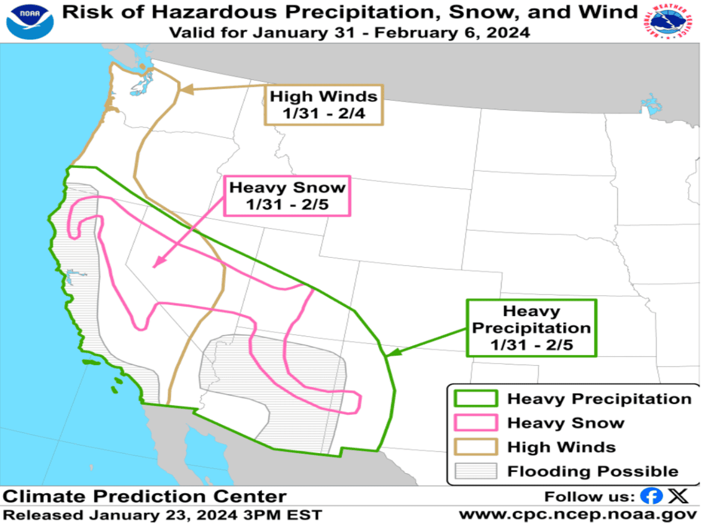
A high risk (greater than 60% chance) of hazardous, heavy precipitation is forecast from January 31 to February 5 across California and Arizona, with a larger area of moderate risk (40 to 60% chance) that includes most of Nevada, southern Utah, and portions of New Mexico. The heavy precipitation can lead to localized flooding and landslides, particularly in regions that have recently received heavy rains. At higher elevations, such as the Sierra Nevada, Klamath Mountains, and the Mogollon Rim, heavy snow is expected.
Hazardous, onshore high winds are likely to impact the West Coast as well from January 31 to February 4, especially the Pacific Northwest southward through California, which could lead to coastal erosion from persistently high waves. High winds are also anticipated to impact interior regions of California and portions of western Nevada. Please stay tuned to shorter-term forecasts*, as specific impacts remain unclear for any given location at this extended forecast range.
The next fast moving weather system will bring additional rain
and mountain snow showers along with gusty winds across the ridges
Wednesday through early Thursday. Showers may persist from the
Tahoe Basin into northwest Nevada Friday and Saturday. Otherwise,
high pressure will bring dry and warmer conditions through the
end of January. Wetter conditions may return for early February.

.DISCUSSION...

* QUIET THROUGH TONIGHT: Fog and low stratus lingered in the
  Carson/Washoe valleys, parts of west central NV and around
  Truckee through late morning before finally breaking up. Outside
  the fog, a mix of blue sky and stratocumulus with near average
  temperatures prevails today. Increasing mid-high level clouds
  ahead of the next fast-moving weather system will reduce the
  coverage of fog tonight.

* SHOWERY WEDNESDAY-WED NIGHT: The next round of precipitation is
  projected to reach the Sierra and northeast CA-far northwest NV
  Wednesday morning, bringing a few hours of steady rain and
  mountain snow before transitioning to a more showery regime
  Wednesday afternoon-Wed night. Snow levels begin relatively low
  around 5000` so light snow may initially fall in the Tahoe Basin
  and foothills. Snow levels then rise during the day, ranging
  from 5500` in northeast CA/northwest NV to 6500-7500` in the
  Sierra from Lake Tahoe southward. A trailing weak wave could
  bring one more push of snow showers back down to 5000-6000` late
  Wednesday night/early AM Thursday with patchy slick travel
  conditions for some Sierra roads and passes. This storm is
  rather modest in strength, with most likely snowfall amounts in
  the 2-6" range (locally up to 8") for the Sierra crest west of
  Tahoe southward to Mono County, with less than 2" for the
  remainder of the Tahoe basin and near the US-395 corridor in
  Mono County. Rainfall amounts will be sparse and generally only
  trace to a few hundredths in far western NV, with a bit more
  (0.10-0.25") across northeast CA-northwest and west central NV.
  Winds increase mainly over the ridges where peak gusts of 60-80
  mph are likely, but mixing looks limited for most lower
  elevations with wind gusts below 25 mph. Gusts could be a bit
  higher around 25-30 mph in the Surprise Valley/northwest NV
  Wednesday afternoon-evening.

* WARMER AND MAINLY DRY END TO JANUARY: After the midweek system
  departs, a ridge of high pressure will begin to build over the
  western US with dry conditions, fewer clouds and near average
  temperatures prevailing Thursday. A couple of weak shortwaves
  within the moist Pacific flow could bring periods of light rain
  showers from the Tahoe Basin northward to the OR border Friday-
  Saturday. The ridge is more likely to amplify later in the
  weekend and hang on through the end of the month, pushing the
  moisture flow farther north while also bringing a late January
  thaw with highs around 60 degrees for most lower elevations,
  and lower 50s for Sierra communities.

* FEBRUARY FLIPS ON THE WET SWITCH?: Looking ahead to the first
  week of February, ensemble cluster guidance is showing a solid
  trend toward more active weather returning to the eastern
  Sierra-western NV, with a 70-80% probability of wetter than
  average on the latest CPC 8-14 day outlook. A broad eastern
  Pacific trough with abundant long-track Pacific moisture is the
  general synoptic pattern presented by the guidance, while areas
  of variance include whether the main moisture feed remains
  directed at the Sierra for a prolonged period or shifts to
  southern CA. The extent of warmer or colder air masses and
  resulting snow levels/impacts also cover a wide range of
  possibilities, so there`s less confidence on this part of the
  longer range forecast until February comes closer.