On Saturday, January 4, an avalanche caught, buried two, and killed one backcountry skier on Radio Tower Peak, Wyoming. A group of four skiers were traversing across a gully when the slope broke with a 400 foot wide crown. One skier was quickly located and just beneath the surface of the snow, while the other buried skier was buried 13 feet beneath the avalanche. After digging for over an hour, the second skier was recovered but unresponsive. CPR was attempted, but unsuccessful.
The Bridger-Teton Avalanche Center just published its full report of the incident. These reports are shared to help everyone learn and grow.
As of January 16, there have been six avalanche-related fatalities in the US this winter.
The full report is below:
Bridger-Teton Avalanche Center Report
Avalanche Comments
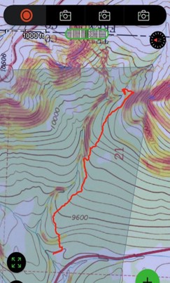
On Saturday, January 4, 2025, at approximately 11:00 am, a group of four skiers unintentionally triggered an avalanche on a north-facing, sparsely treed slope above a steep-walled gully approximately one mile from the parking pullout for Breccia Mountain. The avalanche was remotely triggered from below as the party attempted to cross a gully beneath a wind-loaded ridge. The triggered weak layer was formed during a cold, dry period early in the season. The weak layer was responsible for the region’s numerous human and snowmobile-triggered avalanches the week preceding this accident. This avalanche propagated 350’ uphill to a windloaded 38-40 degree slope, broken by cliff bands and across three distinct avalanche paths. The avalanche crown was 400’ across and ranged from one to four feet thick. The debris was a mixture of hard slab and softer surface snow, which slid 625 feet (400 vertical feet) into a terrain trap (HS-AS(r)-R4-D2.5). The debris carried two members of the group, resulting in one serious injury and one fatality.
Backcountry Avalanche Forecast
The Bridger-Teton Avalanche Center forecast on January 4th for the Togwotee forecast zone was rated Moderate at both elevation zones. The primary avalanche problem was a persistent slab with distribution across every aspect of middle and upper elevation bands, except for duesouth-facing terrain at middle elevations, which was primarily bare ground at this aspect and elevation before December 8th. Avalanches of this problem type were listed as possible to trigger and small to large (D1-D2) in size. The following is the Bottom Line section of the day’s forecast:
It is possible to trigger an avalanche on weak layers buried 1-3 feet deep. These avalanches can be triggered remotely – from above, below, or adjacent to slopes over 30°. Stay alert on steep rocky slopes and areas drifted by the wind. The safest and best riding can be found on sheltered terrain less than 30°.
Weather and Snowpack Summary
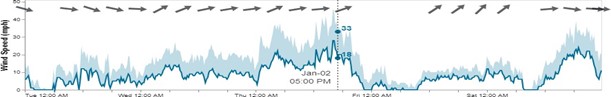
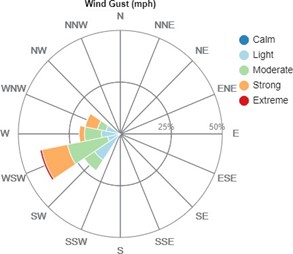
Persistent weak layers formed during dry periods in November and December were identified in the snowpack across all zones in the region. The weak grains in this layer formed when snow that fell during three stormy periods in November and December was exposed to the cold, clear weather typical of this high elevation area. Subsequent storms delivered 8 inches on December 16th, 10 inches on December 30th, and 5 inches on January 1st. Lava Mountain wind station recorded sustained wind speeds from the southwest at 20-30 mph with gusts of 45-50 mph on January 2nd while temperatures warmed to the mid-20s (see figs. 1 and 2). The recent snowfall made 24- 30 inches of snow available to the wind to build thick, dense wind slabs on slopes sheltered from that wind direction.
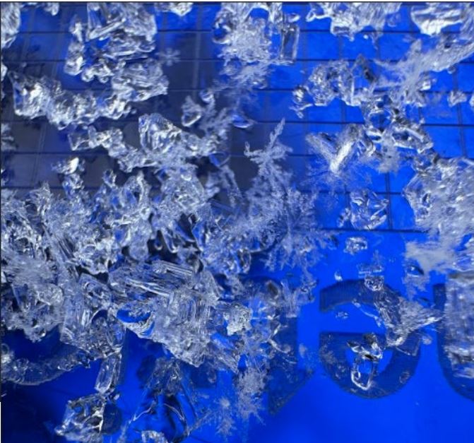
On December 31st, a snowmobiler was buried in a terrain trap near Two Ocean Mountain, approximately one mile from the site of this accident. Fifteen avalanches were reported in an observation posted by the BTAC forecast team on January 2nd. Two public observations were submitted in the previous two weeks, and a full burial of a snowmobiler was reported on January 2nd. These avalanches failed on faceted, weak snow near the ground (Fig. 3) and occurred on many aspects. Most were 1-2 feet thick, with several of them thicker and propagating widely.
Accident Summary
The party involved in this avalanche assisted avalanche center staff in creating this report and provided details such as their GPS track and details about events of the day. We are grateful for the honest sharing of these difficult events.
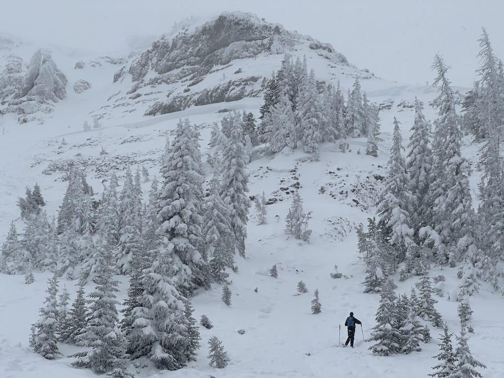
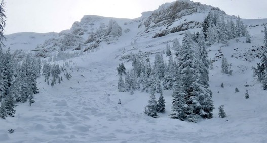
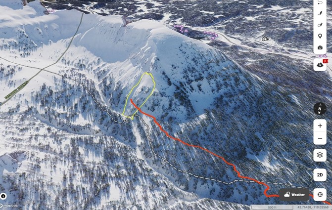
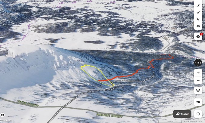
Saturday morning, January 4, 2025, a group of four old friends met at the Breccia Peak turnout for a day of backcountry skiing. The group left the trailhead at 9:40 am with the intention of skiing the lower-angled terrain on the southeast face of Breccia Peak. Kenny Goff led off, following the established skin track to Breccia for a short distance then switched routes to avoid a stream crossing. They continued east roughly following the summer trail towards Brooks Lake Peak. Soon, they found themselves far to the east of their intended route to Breccia. The group stopped and consulted their mapping apps and discussed whether to traverse towards Breccia or go back down. The group looked at their mapping apps and saw a way to contour around the bowl north of Radio Tower Peak that avoided steep terrain. Goff continued to lead the way through the forested slopes beneath the shoulder of the peak, roughly following the route of the summer trail to Brooks Lake Mountain. (Fig 4)
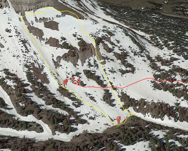
After ¾ mile, the route emerged into more open terrain beneath steeper slopes, and the group spread out for safer travel. Within a few hundred feet, the terrain becomes more alpine in nature, with cliffs and sparse patches of fir trees. Visibility was marginal, with light snowfall and flat light. The group began to cross a gully, first Goff, then skier 2, with skier 3 and 4 hanging back in a patch of trees (Fig 5). Goff was almost across the main gully, with skier 2 a short distance behind, when the slope collapsed with an audible thud. Skier 3 shuffled backward into the safety of the patch of trees with skier 4. Skier 2 saw the slope fail, and saw his friend move downslope in the debris while he attempted to escape toward the edge of the gully though he was soon engulfed in debris as well. The flow somehow pushed him across the top of the bulk of the debris and buried him 20 feet up the drainage, skiers right (east) of Goff.
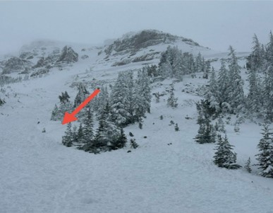
showing the group’s tracks into the avalanche path. The flank wall of the avalanche is visible on the left edge of the picture. Skier 3 and 4 escaped the flow at the red arrow. Photo Credit: Bridger-Teton Avalanche Center
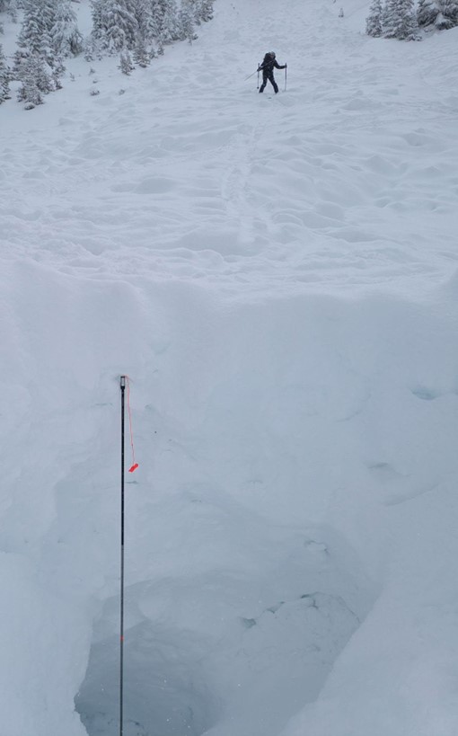
Skiers 3 and 4 began to search and spotted what appeared to be a glove or article of clothing which they found to be skier 2’s hand. Skier 3 uncovered skier 2’s face then began to dig him out. Meanwhile, skier 4 had acquired a signal though he was initially confused at the high numbers on the screen. They soon realized the beacon was working normally but the high number was due to the 4.2-meter (14 foot) depth of burial. Skier three began digging for Goff. At 11:32 am, skier 4 texted 911 via a new phone with satellite-to-911 capabilities that an avalanche accident had occurred. By 11:46 am, the injured skier was completely excavated. The group then put all of their efforts into digging for Goff while occasionally taking breaks to text more information to the 911 operator. They dug through the hard debris for an hour and a half. Once they reached their friend, they were forced to dig horizontally to free him from his skis and finally lift him out of what was now a 13-foot-deep hole. Skiers 3 and 4 reported that they had begun CPR at 1:04 pm and continued until 2:37 pm. Rescuers from TCSAR arrived on the scene at 4:00 pm and packaged Skier 2 in a rescue toboggan and skied him to a waiting ambulance. The rescue crew returned in the dark to bring out Goff.
Comments
The survivor’s of this avalanche reflected on the mental shortcuts that may have been at play on the day of the accident and graciously offered the following:
“Here is some more context and insight into our thoughts and approach to the day.
- The general mindset of the group going into the day was skiing something mellow with good friends on a “moderate” danger day and try to avoid avy terrain. We all read the avalanche forecast that day together. In hindsight, we wish we would have dived into, analyzed, and discussed the problems and hazards more as a group: remote triggering, wind-loaded slopes, the weak layer.
- The biggest heuristics at play for us was familiarity/comfort with the group and expert halo. We had all taken many trips into the mountains together, deeply trusted one another, and trusted the collective skill set and experience of the group. This all made it easier for our brains to go into cruise control. We also relied on “Kenny has been here before”—backcountry skiing on Togwotee. We are in no way using that as an excuse for our own complacency or shifting responsibility to Kenny, just merely identifying our own shortcomings as a group.
- Just before the site of the accident, all three of us noticed and registered that the terrain above us was getting steeper (above 30 degrees). None of us voiced this.” – email from the survivors
Accidents like this one are tragic, especially for those directly involved and their families. These events also powerfully impact the small communities where those involved work and play. We hope to shed light on the contributing factors that led to the incident in order to learn from them and help people avoid future tragedies. In addition to the above insights from the group, we offer these thoughts:
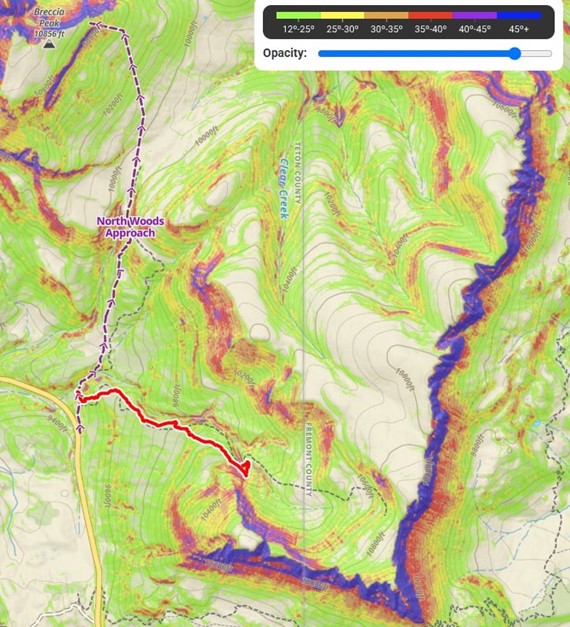
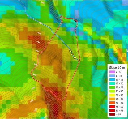
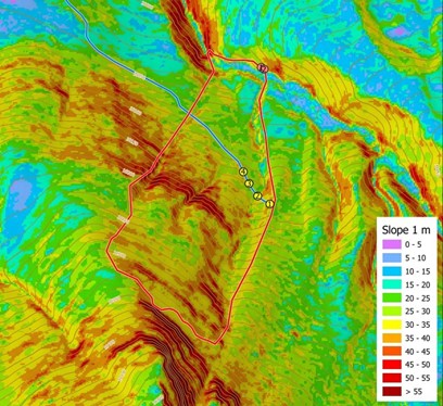
After realizing their distance from the typical route to Breccia, the group chose an alternate route using slope angle maps in order to avoid avalanche terrain. While there does appear to be a low angle route to connect with Breccia, using a digital elevation model to choose a route raises two issues. Persistent slabs can propagate a crack great distances upon collapse. The forecast referred to the danger of remote triggering which means travelling below the steep slopes shown on the map is the same as entering avalanche terrain. The second issue here is that the digital elevation models commonly used on mapping apps can be deceptive. If the map uses a 10m (33 foot) resolution that means a cliff 9m (30 feet) tall may not show up on the map. Indeed the map this group used underrepresents the steepness of the cliff bands above their route as well as the small, steep sidewall directly in the path of the group’s skin track (Fig. 6).
Perhaps that spot was the trigger point, the proverbial domino that sent the slope cascading down on them. Whatever the resolution of the DEM, paying attention directly, without the bias that a digital slope angle map may convey, is critical. Additionally, failing to find another way around when confronted with the steep slope above may have been a commitment or consistency bias to the new plan, despite the newly discovered information regarding slopes above. This commitment heuristic can be hard to shake in a group.
Weak basal facets are prevalent in the Togwotee area each year. That weak snow becomes a significant problem when it is heavily loaded by wind slabs. The new snow and wind loading prior to this accident stressed the snowpack making it easier for the group to trigger. The team had heard or felt none of the whoompfs or collapses which are characteristic warning signs for this type of avalanche problem until the slope failed. BTAC investigators also felt or heard no cracking or collapsing. This is characteristic of persistent or deep persistent slab avalanche problems. The most effective management strategy for this type of avalanche problem is to reduce your exposure to the hazard; this includes being mindful of what is above and below you when you are travelling. The debris from this avalanche piled up deeply in the steep-sided drainage below. Terrain traps like these raise the consequence of even a small avalanche and are common beneath many small slopes in the Togwotee area. An avalanche of this size into that terrain trap is virtually unsurvivable, no matter the number or speed of rescuers. (Fig 7) Everyone is subject to the biases and traps of thinking; only with absolute vigilance can we avoid falling into them. Shame, blame and derision have no positive function in the aftermath of any accident; we could all easily make the same mistakes.
We are deeply saddened and offer our sincere condolences to the family, friends and community.
I really appreciate these reports. RIP Kenny. Sounded like a great guy.