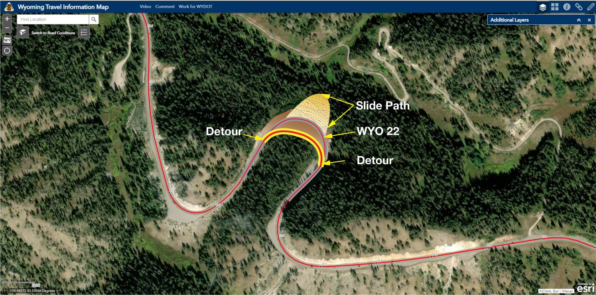
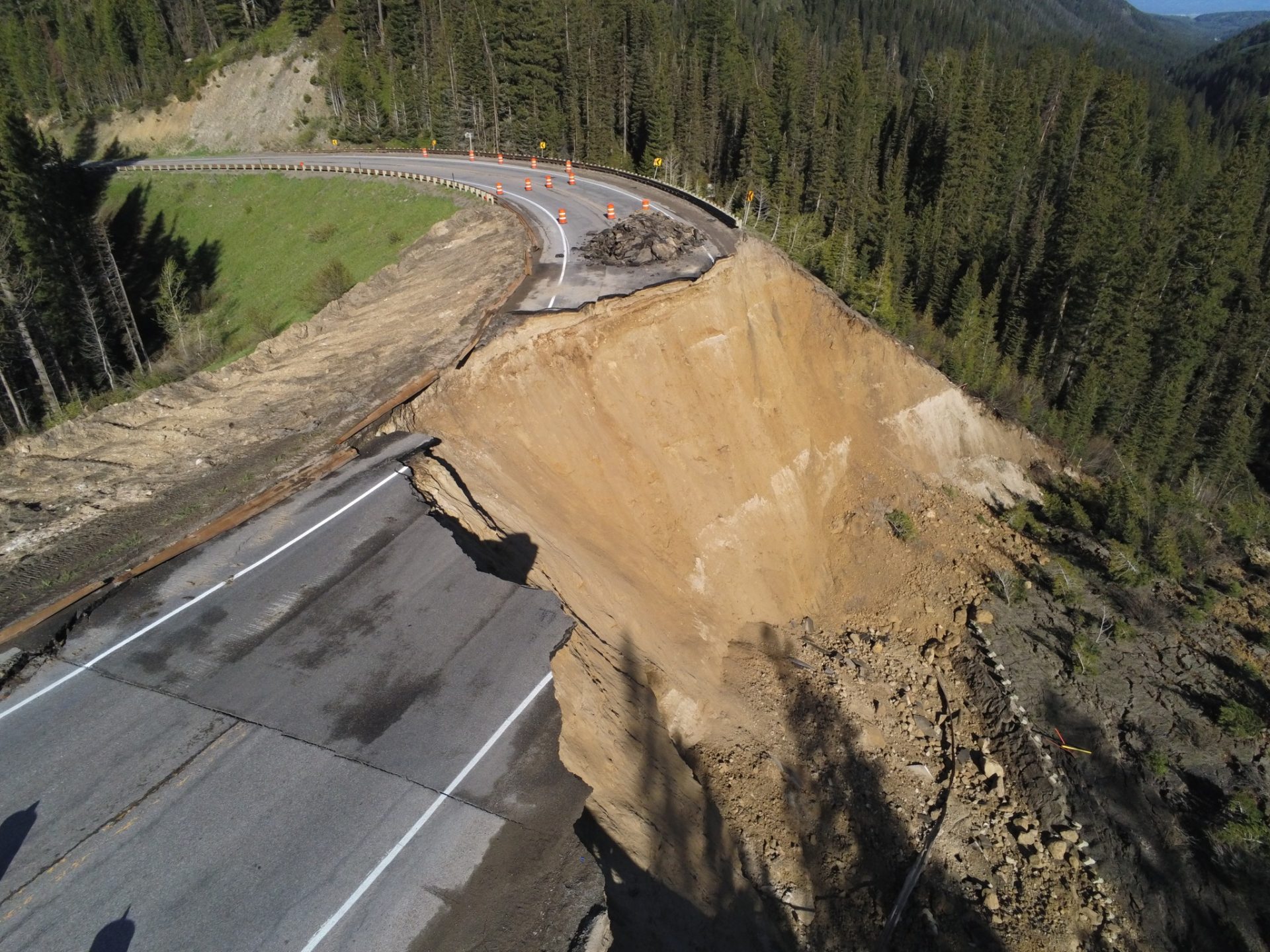
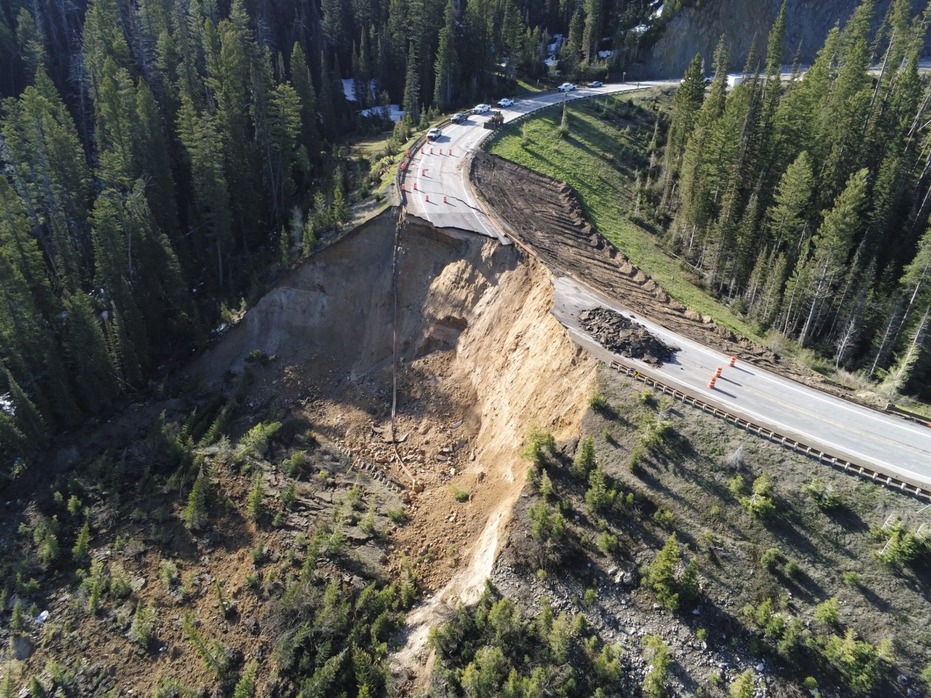
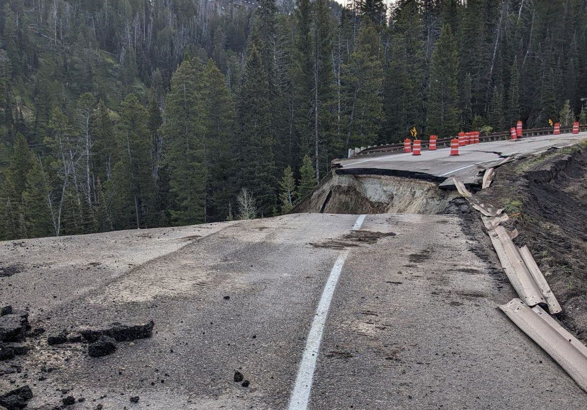
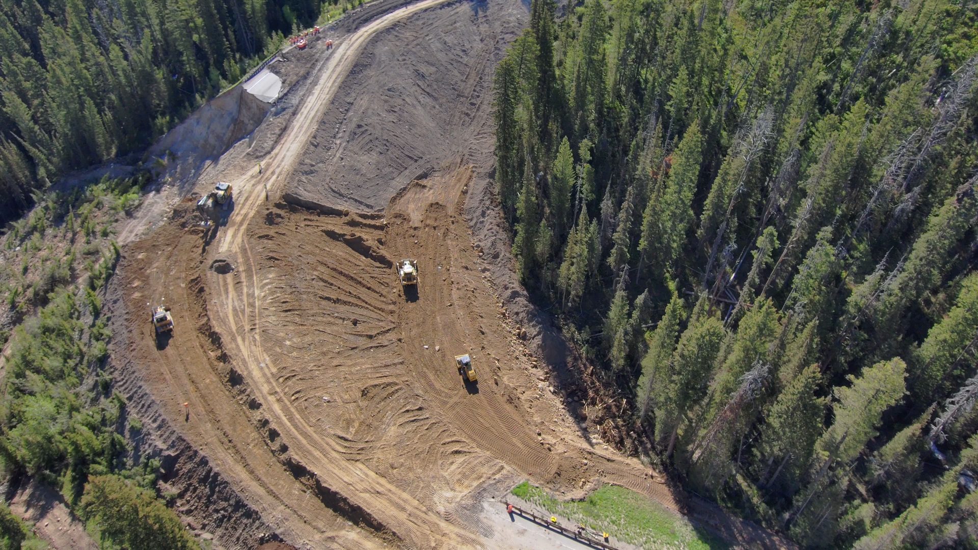
On June 8, the Wyoming Department of Transportation (WYDOT) reported that a large chunk of Teton Pass Road, also known as Wyoming Highway 22, “catastrophically failed” near milepost 12.8. The road is a critical part of the community that connects Jackson Hole to Victor, Idaho. On June 13, an emergency bid to fix the road was awarded to Avail Valley Construction LLC during a special meeting.
Now WYDOT has created a “Big Fill Slide Frequently Asked Questions” page to address what many people are wondering about the project’s logistics and safety. See the questions and answers below.
Why did the slide occur?
Wyoming State Highway 22, Teton Pass, was constructed to link communities over a mountain range. Whenever you build a roadway through mountainous terrain, there is an inherent risk of mudslides, rockfall, landslides, and other earth movement and erosion. With recent rapid warming temperatures (+25 degrees), the snowpack in the mountains melted quickly, saturating the native material under the fill of the road and lubricating the clay materials until it moved. The native soil under the road fill material failed, resulting in it sliding out and causing the road and big fill material to collapse.
Didn’t WYDOT know the road was failing as soon as the first crack appeared?
On Thursday, when crews responded to the report of a crack in the road, WYDOT geologists were notified, and careful evaluation and investigation of the entire area began. Teton Pass is a young mountain range and has seen geologic movement (in the form of erosion) over time. WYDOT Geologists have been monitoring areas on the pass for many years. An inclinometer previously was installed in the area of the big fill slide to record subsurface movement. It was read on May 15 of this year, and geologists had not seen any unmanageable movement (less than 0.1 of an inch per year) up to that point. Unfortunately, Mother Nature and her warming temperatures accelerated the movement. Conveniently, the road was already closed due to a mudslide event nearby on Friday, but WYDOT would have immediately closed the road due to unsafe conditions after seeing the additional movement. Traffic would not have been on the road during the slide if the mudslide had not occurred.
Why build a road where landslides could occur?
Basically, anytime you build a road through a mountain range, you run the risk of potential landslides. Departments of Transportation across the country work hard to mitigate the risk of road failure. If transportation officials only built roadways in landslide-free areas, it would be hard to connect communities throughout the Rocky Mountain Region, or any mountain range. Without these roads, communities would be isolated without access to economic resources and emergency services.
Aren’t you worried it could happen again?
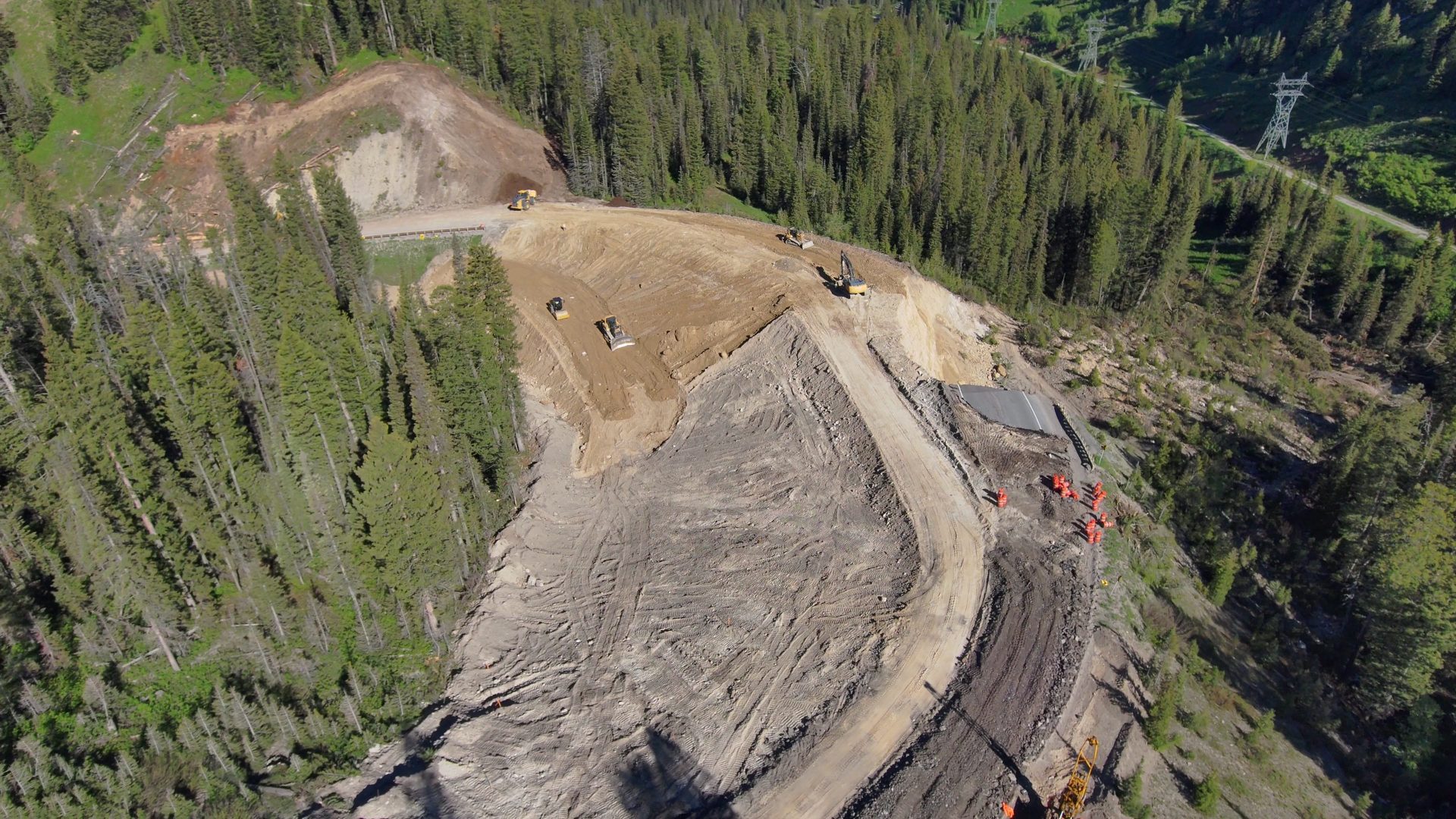
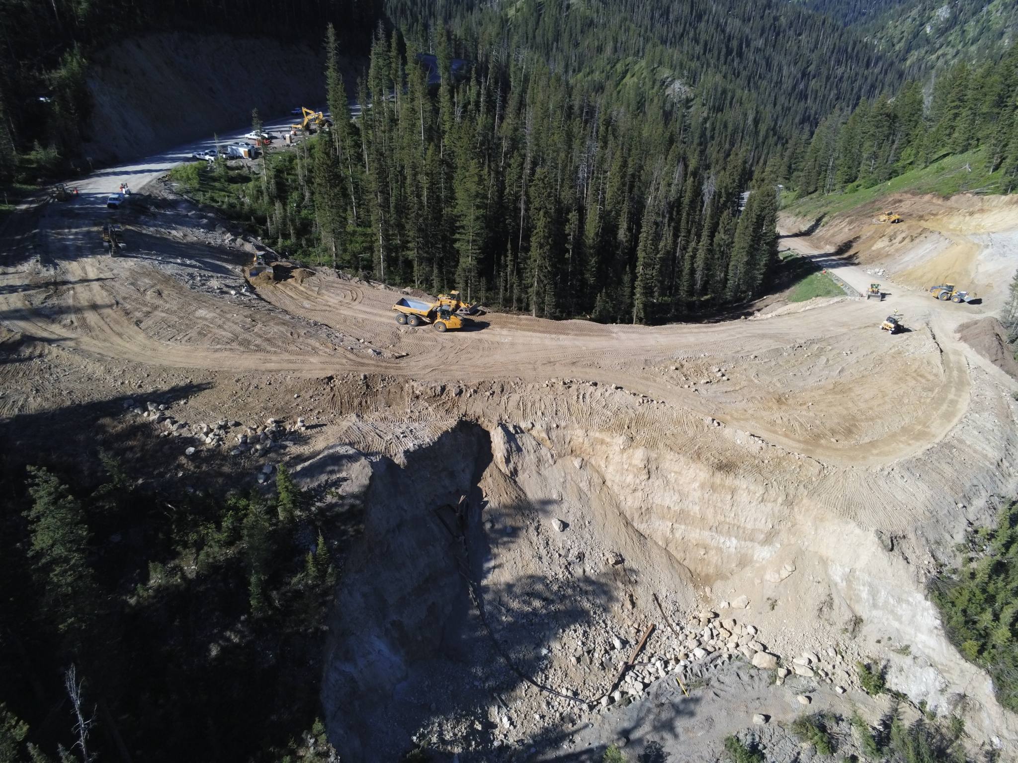
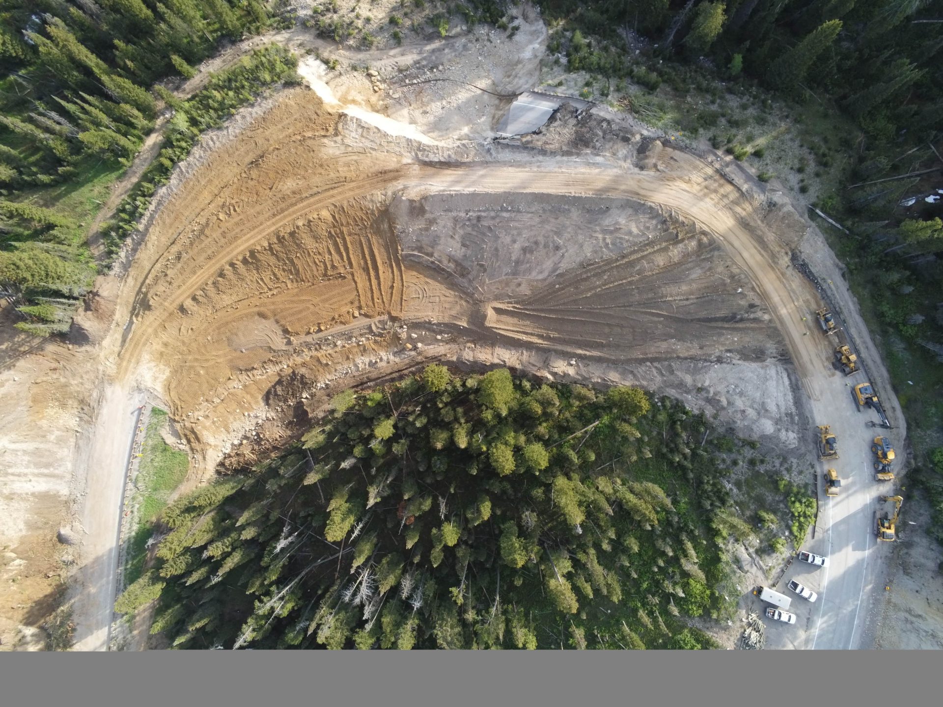
As with all mountain roads, there is a risk of geologic movement that could affect the road. However, WYDOT is carefully evaluating and working to mitigate risk of road failure. This includes constant monitoring and drilling/sampling investigations, as well as pursuing and completing projects to address drainage improvements and better road design to improve weight distribution to discourage ground movement. The fill material did not fail but went for the ride when the underlying soils reached a point of saturation. The fill is good material and is being combined with quality borrowed material to complete the detour. The natural ground that yielded under the “Big Fill” has a different composition than under the detour. Natural ground below the “temporary” detour is less wet, harder, or more compact, and has not been subjected to large “big fill” loads (stress) when compared to the original alignment.
How is the work happening so fast? Doesn’t it take WYDOT longer to get projects constructed?
WYDOT does have an emergency repair protocol in place to address situations like a landslide. Emergencies happen all across the state, and WYDOT is prepared with a team of experts to act quickly when necessary. Responding to these types of emergencies, which includes things like landslides, debris flows/mudslides, flooding and other road damage caused by acts of nature, takes time and money, so it’s not something the agency does for every project. As another example, WYDOT would conduct an emergency project to repair a bridge damaged in a crash.
Why not just build a bridge there?
WYDOT engineers are currently reviewing what kind of permanent design would be the best to build in the area. However, the steep grades would make it difficult to build any kind of acceptable grade with a bridge. This is why you generally see switchback-type designs through the mountains. It’s a safer way to traverse steep grades for vehicles. General safety design indicates that a 5-6 percent grade is a safe steepness for most vehicles. Teton Pass was built in the 1960s with a 10 percent grade. A bridge through the area would more than likely have a 20-25 percent grade. To put it in perspective, average ski hill runs with a “blue square designation” would likely have around a 25 percent grade. It wouldn’t be safe to put vehicles on that steep of a grade in the wintertime on snow-packed roads.
Can WYDOT add a wildlife crossing, bike path, or other improvements while conducting these road repairs?
Thanks to the Governor’s Emergency Declaration on June 8, WYDOT is looking to tap into emergency Federal funding through the Federal Highway Administration and the US Department of Transportation. Part of the stipulations of that funding is that the infrastructure has to be rebuilt to its former state. Of course, it must meet today’s construction standards and specifications, but additional infrastructure cannot be added unless paid for with separate funds.
How is WYDOT going to make sure the temporary detour is safe for travel?
WYDOT is doing a few things to make sure vehicles can safely utilize the detour through the slide area. Crews are addressing drainage concerns to ensure a more solid foundation for the road. Geologists are also mapping the site to confirm there are better native soils under the roadway. In addition, the detour road will put less weight on the active area, relieving some of the driving forces pushing on the slide zone.
If the detour is safe to travel, why not just build the new permanent road there?
The detour will be steeper with a sharper corner, so WYDOT will reduce the speed through the area to make it safer for drivers. The permanent roadway design will provide an adequate foundation and reduce weight.
How is WYDOT making sure the new permanent alignment will be safe?
WYDOT geologists will continue to map, assess, and investigate the area, and additional mitigation measures will be taken to lessen the risk of failure. WYDOT engineers, geologists, and planning personnel are currently researching numerous potential options for what that will look like.
Will the detour and new alignment improve drainage in the area?
Yes, stormwater drainage evaluations are a standard part of construction and will continue to be evaluated. The appropriate measures will be in place to ensure proper drainage for the temporary detour and future reconstruction. The design of the detour addressed drainage improvements by contouring the fill to ensure no ponding of water and allowed water flows to be directed away from the temp detour. The existing contours of the original alignment lend to surface run-off to be naturally carried away from the fill. The 1969 engineers conveniently placed the roadway that did not require culverts for drainage. As an analogy, they placed the road fill at the continental divide where water to the north drains in one direction and the water to the south drains in the opposite direction.
Why didn’t WYDOT address this slide sooner?
WYDOT has been monitoring this creeping slide for decades. This section of road was re-paved in 2004 and patched last fall after slow, consistent creep over the past 20 years. Most recently, WYDOT’s geologists installed an inclinometer, a device that measures subsurface slide movement, in the fall of 2023 to monitor this area. Prior to this incident, the slide moved less than an inch per year. A perfect storm of rain early in the week, followed by a rise in daily temps, and overnight temps above freezing resulted in rapid snow melt that saturated groundwater conditions which exponentially sped up this slide movement to the failure we saw June 8. There was no indication of possible failure as this slide did not move quickly for decades.
There may still be more questions many people have. We certainly hope that the road will open again soon and will be safe and effective for everyone. Stay tuned to SnowBrains for more updates.