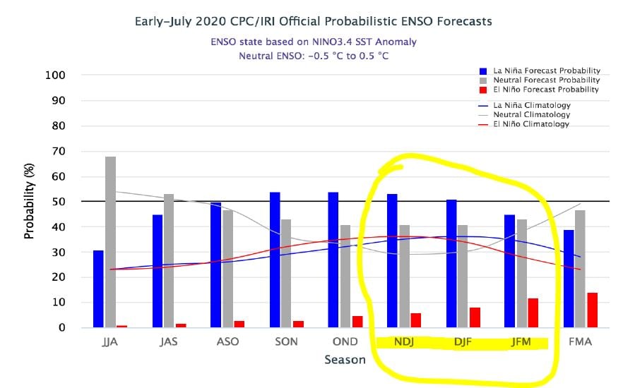
The NOAA predicts that there is a 50-55% chance that next winter will be influenced by a La Niña weather pattern. Of course, it being only July, predicting a La Niña is still “going out on a limb for a long-range forecast,” according to Colorado meteorologist Chris Tomer.
- Related: NOAA Issues La Niña Watch: 50-55% Chance of La Niña Developing in Fall and Lasting Through Winter
However, a potential La Niña weather pattern for next season will still have direct effects on Colorado’s many mountain ranges. Tomer wrote in a recent Facebook post,
“Winter 2020-2021 may be influenced by a developing La Nina. NOAA officially issued a “La Nina Watch” for Fall and Winter. They put the odds at 50-55%. Last winter El Nino was in control. I always caution the accuracy of these long range (3 months plus) outlooks, but it does at least give us a hint of what direction the atmosphere is leaning. Sea surface temps are just one variable (albeit important) when putting together outlooks. What does this mean for Colorado? I would favor the Northern Mountains for the most consistent snowfall this winter. Places like Steamboat, Cameron Pass, and areas closer to Winter Park and Loveland. I’ll put a more detailed report together on this soon.”
According to Tomer, El Niño winters are big snowfall-drivers for Colorado as these weather patterns tend to make the southern branch of the Pacific jet stream more active, pulling in Pacific moisture. La Niñas, on the other hand, make the northern branch more active.