Once a powerful category 4 hurricane, Hilary weakened and made landfall in northern Mexico on August 20, 2023, pelting the Baja California peninsula and two U.S. states with rain.
Before making landfall, Hilary delivered torrential rain to Santa Rosalía in Mexico’s state of Baja California Sur. One person was killed by the floodwater, according to officials. Hilary weakened to a tropical storm before it came ashore on the northern end of the peninsula at around 11 a.m. Pacific Time on August 20, 2023. As the storm moved inland over Southern California, it left flooding, mudslides, and power outages behind.
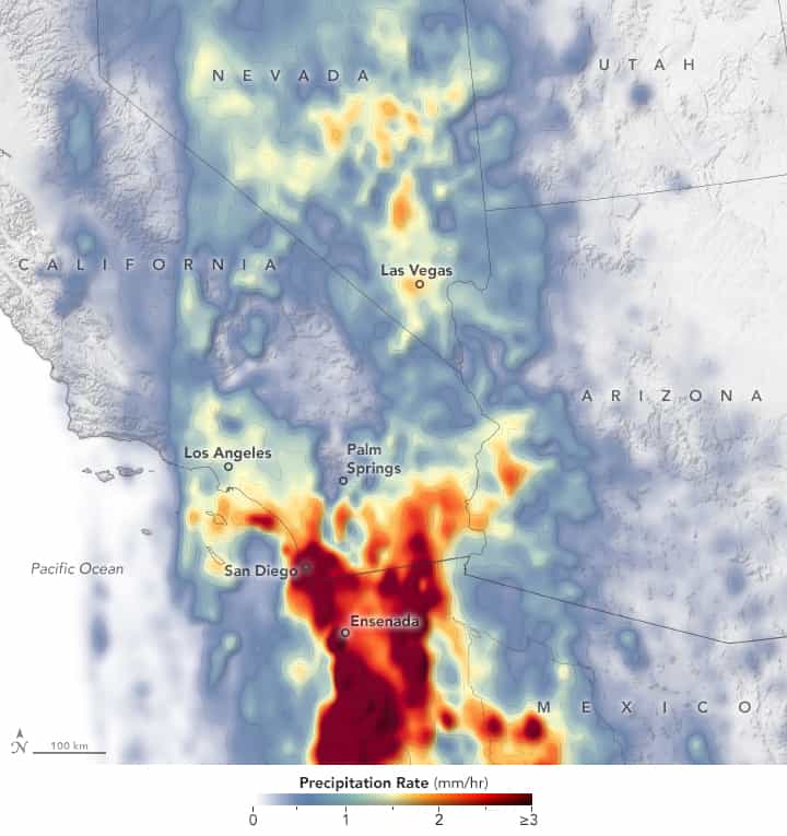
The map above depicts a satellite-based estimate of the storm’s rainfall rates. Data for the map were acquired between 5 p.m. Pacific Time on August 19 and 2 p.m. Pacific Time on August 20, as the center of the storm was approaching Southern California. The darkest reds reflect the highest rainfall rates, with the Baja California peninsula seeing the heaviest rains during this time. The data are remotely sensed estimates that come from the Integrated Multi-Satellite Retrievals for GPM (IMERG), a product of the Global Precipitation Measurement (GPM) satellite mission. Due to the averaging of the satellite data, local rainfall rates may be significantly higher when measured from the ground.
August 20 was the wettest August day on record for both downtown Los Angeles and San Diego, according to the National Weather Service. They received 2.5 inches (6.3 centimeters) and 1.8 inches (4.6 centimeters) of rain, respectively. The storm also brought wind gusts of 70 miles (113 kilometers) per hour to parts of California, knocking over trees and power lines, and reportedly leaving 40,000 residents without power. Death Valley National Park closed due to flooding, and several roads were also flooded and damaged in Las Vegas, Nevada.
So far, some of the most severely affected places in the U.S. have been the normally dry desert regions of Southern California. Streets turned into rivers of mud in Palm Springs after the city received six months of rain over six hours. Flooding also closed roads in Coachella Valley, including I-10, the major highway in the region.
August is typically a dry month in Southern California, but the surface layers of soil can respond quickly to weather events. Scientists at NASA’s Short-term Prediction Research and Transition Center (SPoRT) expected that rain from the storm could saturate soils in the region for several days.
Hilary continued to move north into Oregon and Idaho on August 21, where rainfall totals of up to 3 inches (7.6 centimeters) were anticipated in places, with potential for flash flooding.
This post first appeared on NASA Earth Observatory. NASA Earth Observatory image by Lauren Dauphin, using IMERG data from the Global Precipitation Mission (GPM) at NASA/GSFC. Story by Emily Cassidy.