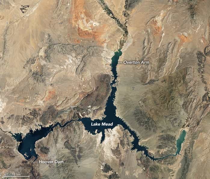
Continuing a 22-year downward trend, water levels in Lake Mead stand at their lowest since April 1937, when the reservoir was still being filled for the first time. As of July 18, 2022, Lake Mead was filled to just 27 percent of capacity.
The largest reservoir in the United States supplies water to millions of people across seven states, tribal lands, and northern Mexico. It now also provides a stark illustration of climate change and a long-term drought that may be the worst in the U.S. West in 12 centuries.
The low water level comes at a time when 74 percent of nine Western states face some level of drought; 35 percent of the area is in extreme or exceptional drought. In Colorado, location of the headwaters of the Colorado River, 83 percent of the state is now in drought, and the snowpack from last winter was below average in many places.
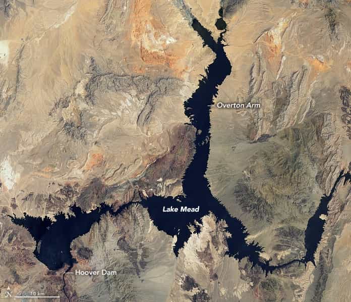
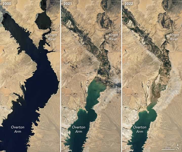
The natural-color images above were acquired on July 6, 2000, and July 3, 2022, by Landsat 7 and Landsat 8. The detailed images below also include a view from Landsat 8 on July 8, 2021 (middle). The light-colored fringes along the shorelines in 2021 and 2022 are mineralized areas of the lakeshore that were formerly underwater when the reservoir was filled closer to capacity. The phenomenon is often referred to as a “bathtub ring.”
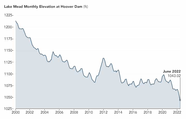
The lake elevation data below come from the U.S. Bureau of Reclamation (USBR), which manages Lake Mead, Lake Powell, and other portions of the Colorado River watershed. As of July 18, 2022, the water elevation at the Hoover Dam was 1041.30 feet (317.4 meters) above sea level; the water elevation at the end of July 2000 (around the time of the Landsat 7 image above) was 1199.97 feet (341 meters). Lake levels at the dam should stay above 1000 feet to continue operating hydropower turbines at normal levels.
At maximum capacity, Lake Mead would reach an elevation 1,220 feet (372 meters) near the dam and would hold 9.3 trillion gallons (36 trillion liters) of water. The lake last approached full capacity in the summers of 1983 and 1999.
About 10 percent of the water in Lake Mead comes from local precipitation and groundwater each year, with the rest coming from snowmelt in the Rocky Mountains that flows down the Colorado River watershed through Lake Powell, Glen Canyon, and the Grand Canyon. The Colorado River basin is managed by USBR and other agencies to provide electric power and water to roughly 40 million people—most notably the cities of San Diego, Las Vegas, Phoenix, and Los Angeles—and 4 to 5 million acres of farmland in the Southwest. The river water is allotted to states (including tribal lands) and Mexico through laws like the 1922 Colorado River Compact.
Above Lake Mead, Lake Powell is currently filled to just 27 percent of capacity, and the entire Colorado river system stands at 35 percent. USBR announced in August 2021 that state water allocations would be cut in 2022; further modeling and negotiation is underway for 2023 allocations. In June 2022, USBR issued an emergency request to the Colorado River basin states to reduce water usage by 2 million to 4 million acre-feet over the next 18 months.
In addition to serving as a major drinking and irrigation source for the Southwest, Lake Mead is a national recreation area that is particularly popular with boaters. According to the National Park Service, five of six boating ramps/launches are now closed. “Declining water levels due to climate change and 20 years of ongoing drought have reshaped the park’s shorelines,” the Park Service said on its website. “As Lake Mead continues to recede, extending launch ramps becomes more difficult and more expensive due to the topography and projected decline in water levels.”
This post first appeared on NASA Earth Observatory. NASA Earth Observatory images by Lauren Dauphin, using Landsat data from the U.S. Geological Survey and and lake elevation data from the Bureau of Reclamation. Story by Michael Carlowicz.
The BIGGEST problem is population growth in the west. A lot of areas have a straw in Lake Mead like Las Vegas, Phoenix, and SoCal. All of these areas have had significant growth in the last 20 years. Unless conservation efforts or technology improves, I see the water supply of the west no longer meeting demand in the not too far future. I’d sell my house if I lived in Vegas. Of course if someone would invent cold fusion we’d be set. I’d do it but…. I am too busy skiing. Good luck Planet Earth.