
NOAA just released their latest El Nino update on September 4th. They are now saying there is a 60-65% chance of El Nino during the Northern Hemisphere’s Fall & Winter. These are the same numbers we saw in their El Nino update a month ago.
If we do have El Nino this winter it will be a weak El Nino. What does a weak El Nino mean for precipitation in North America?
“Approximately one-third of the (weak) events featuring above-average precipitation, one-third near-average precipitation, and one-third below-average precipitation” – NOAA
NOAA’s latest El Nino update is below:
EL NIÑO/SOUTHERN OSCILLATION (ENSO)
DIAGNOSTIC DISCUSSION
issued by
CLIMATE PREDICTION CENTER/NCEP/NWS
and the International Research Institute for Climate and Society
4 September 2014
ENSO Alert System Status: El Niño Watch
Synopsis: The chance of El Niño is at 60-65% during the Northern Hemisphere fall and winter.
During August 2014, above-average sea surface temperatures (SST) continued across much of the equatorial Pacific (Fig. 1).

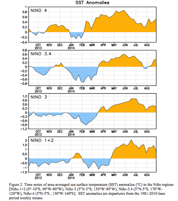
Most of the Niño indices warmed during the month with values of +0.5°C in Niño-4, +0.4°C in Niño-3.4, +0.4°C in Niño-3, and +0.8°C in Niño-1+2 (Fig. 2).
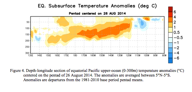
Subsurface heat content anomalies (averaged between 180º-100ºW) also increased during the month (Fig. 3) as above-average subsurface temperatures developed across the central and east-central equatorial Pacific (Fig. 4).

This warming is associated with the downwelling phase of an equatorial oceanic Kelvin wave triggered in July by low-level westerly wind anomalies. Westerly wind anomalies continued in the central and eastern part of the basin early in August, but weakened by the end of the month. Enhanced easterly upper-level wind anomalies have prevailed during much of the month, and the Southern Oscillation Index has been negative. However, convective cloudiness remained generally near average over most of the region, except for below average cloudiness observed across the central and western Pacific (Fig. 5).

The lack of a coherent atmospheric El Niño pattern and near-average SSTs in the central Pacific indicate a continuation of ENSO-neutral.
Most of the models continue to predict El Niño to develop during September-November and to
continue into early 2015 (Fig. 6).
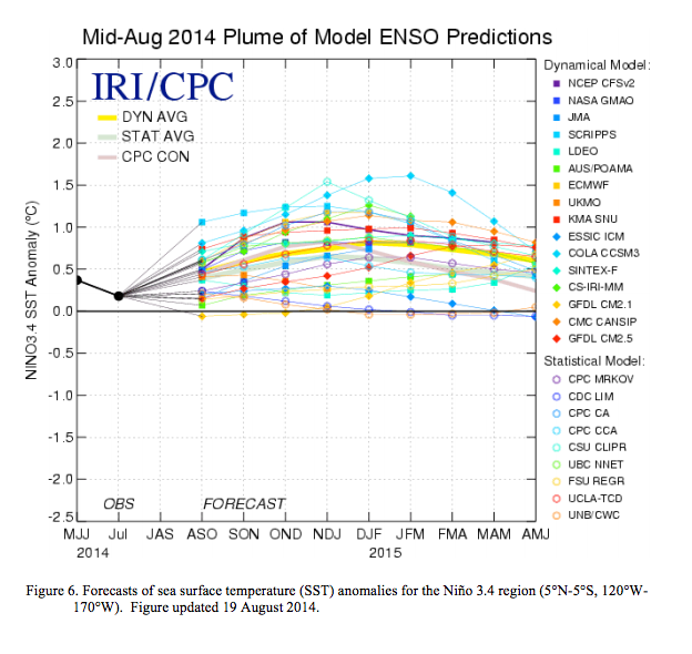
A majority of models and the multi-model averages favor a weak El Niño. At this time, the consensus of forecasters expects El Niño to emerge during September-October and to peak at weak strength during the late fall and early winter (3-month values of the Niño-3.4 index between 0.5°C and 0.9°C). The chance of El Niño is at 60-65% during the Northern Hemisphere fall and winter (click CPC/IRI consensus forecast for the chance of each outcome).
One thought on “NOAA 2014/15 El Nino Winter Outlook for the USA:”