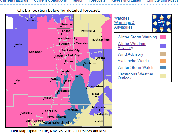
“UPGRADE: Winter storm warnings are now in effect for much of northern and western Utah. Watches have been issued for the eastern valleys. Note: this storm will last for multiple days with breaks in the snow at times.”
– NOAA, SLC UT, 11/26/19
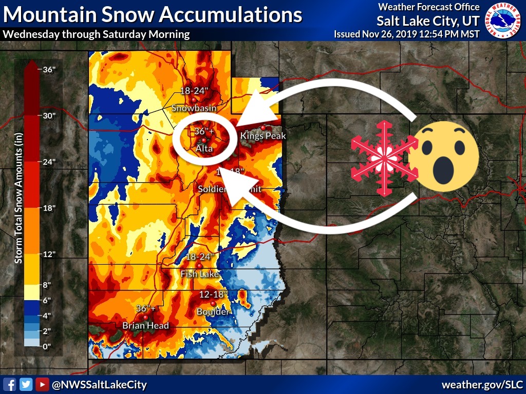
NOAA is currently calling for 36″ of snow to fall at Alta Ski Area, UT in the next 4-days (Wednesday-Saturday).
NOAA is calling for some locations to receive up to 4-feet of snow.
* WHAT...Heavy snow expected. Total snow accumulations of 1 to 3
  feet with isolated amounts up to 4 feet.
- NOAA, SLC UT, 11/26/19
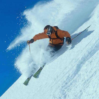
Alta will open for the 2019/20 season on Friday, November 29th to what appears to be a full-on powder day.
We’ve skied Alta a couple of times (when uphill access was still allowed) this month and they most certainly have a solid groomer set up from the top of the Collins lift to the base area.
Backcountry skiing is not recommended during this storm.
The Utah Avalanche Center & NOAA have issued an Avalanche Watch for today that will likely be extended .
* AVALANCHE DANGER…THE AVALANCHE DANGER IS EXPECTED TO REACH HIGH WITH THE FORECAST SNOW AND WIND.
* REASON/IMPACTS…DANGEROUS AVALANCHE CONDITIONS ARE EXPECTED. HUMAN TRIGGERED AND NATURAL AVALANCHES ARE LIKELY. STAY OFF OF AND OUT FROM UNDER SLOPES STEEPER THAN 30 DEGREES. AVALANCHES MAY BE TRIGGERED FROM A DISTANCE OR FROM BENEATH STEEP SLOPES.
– NOAA, SLC UT, 11/26/19
Utah Ski Resorts Open This Week:
- Park City
- Brighton
- Brian Head
- Alta (scheduled to open 11/29)
- Snowbird (scheduled to open 11/29)
- Solitude (scheduled to open 11/29)
- Snowbasin (scheduled to open 11/30)
Winter Storm Warning for Alta, UT
URGENT - WINTER WEATHER MESSAGE
National Weather Service Salt Lake City UT
235 PM MST Tue Nov 26 2019

...Long duration potent winter storm to impact Utah through
Saturday...

Wasatch Mountains I-80 North-Wasatch Mountains South of I-80-
Western Uinta Mountains-Wasatch Plateau/Book Cliffs-
Central Mountains-
Including the cities of Woodruff, Randolph, Alta, Brighton,
Mirror Lake Highway, Scofield, Cove Fort, Koosharem,
and Fish Lake

...WINTER STORM WARNING REMAINS IN EFFECT FROM 4 AM WEDNESDAY TO
10 AM MST SATURDAY...

* WHAT...Heavy snow expected. Total snow accumulations of 1 to 3
  feet with isolated amounts up to 4 feet.

* WHERE...Wasatch Plateau/Book Cliffs, Western Uinta Mountains,
  Wasatch Mountains South of I-80, Wasatch Mountains I-80 North
  and Central Mountains.

* WHEN...From 4 AM Wednesday to 10 AM MST Saturday.

* IMPACTS...Travel could be very difficult to impossible.

* ADDITIONAL DETAILS...For graphical depictions of the snowfall
  forecast, including Official NWS Forecast, High End Amount, and
  Low End Amount, visit weather.gov/slc/winter.
Avalanche Watch for Utah
BULLETIN - IMMEDIATE BROADCAST REQUESTED
BACKCOUNTRY AVALANCHE WATCH
FOREST SERVICE UTAH AVALANCHE CENTER SALT LAKE CITY UT
RELAYED BY NATIONAL WEATHER SERVICE SALT LAKE CITY UT
551 AM MST TUE NOV 26 2019

THE FOLLOWING MESSAGE IS TRANSMITTED AT THE REQUEST OF THE
FOREST SERVICE UTAH AVALANCHE CENTER.

THE FOREST SERVICE UTAH AVALANCHE CENTER IN SALT LAKE CITY HAS
ISSUED A BACKCOUNTRY AVALANCHE WATCH.

* TIMING...IN EFFECT FROM 6AM MST THIS MORNING TO 6AM MST
  WEDNESDAY MORNING.

* AFFECTED AREA...FOR THE CENTRAL AND SOUTHERN WASATCH RANGE,
  INCLUDING THE WESTERN UINTAS.

* AVALANCHE DANGER...THE AVALANCHE DANGER IS EXPECTED TO REACH
  HIGH WITH THE FORECAST SNOW AND WIND.

* REASON/IMPACTS...DANGEROUS AVALANCHE CONDITIONS ARE EXPECTED.
  HUMAN TRIGGERED AND NATURAL AVALANCHES ARE LIKELY. STAY OFF OF
  AND OUT FROM UNDER SLOPES STEEPER THAN 30 DEGREES. AVALANCHES
  MAY BE TRIGGERED FROM A DISTANCE OR FROM BENEATH STEEP SLOPES.

BACKCOUNTRY TRAVELERS SHOULD CONSULT WWW.UTAHAVALANCHECENTER.ORG
OR CALL 1-888-999-4019 FOR MORE DETAILED INFORMATION.

THIS WATCH DOES NOT APPLY TO SKI AREAS WHERE AVALANCHE HAZARD
REDUCTION MEASURES ARE PERFORMED.