Today, the NOAA released its 6-10 and 8-14 day outlooks, covering the first half of March.
Below is an AI-generated summary for those unfamiliar with meteorological jargon, and further down is the full NOAA discussion for those wanting to nerd out!
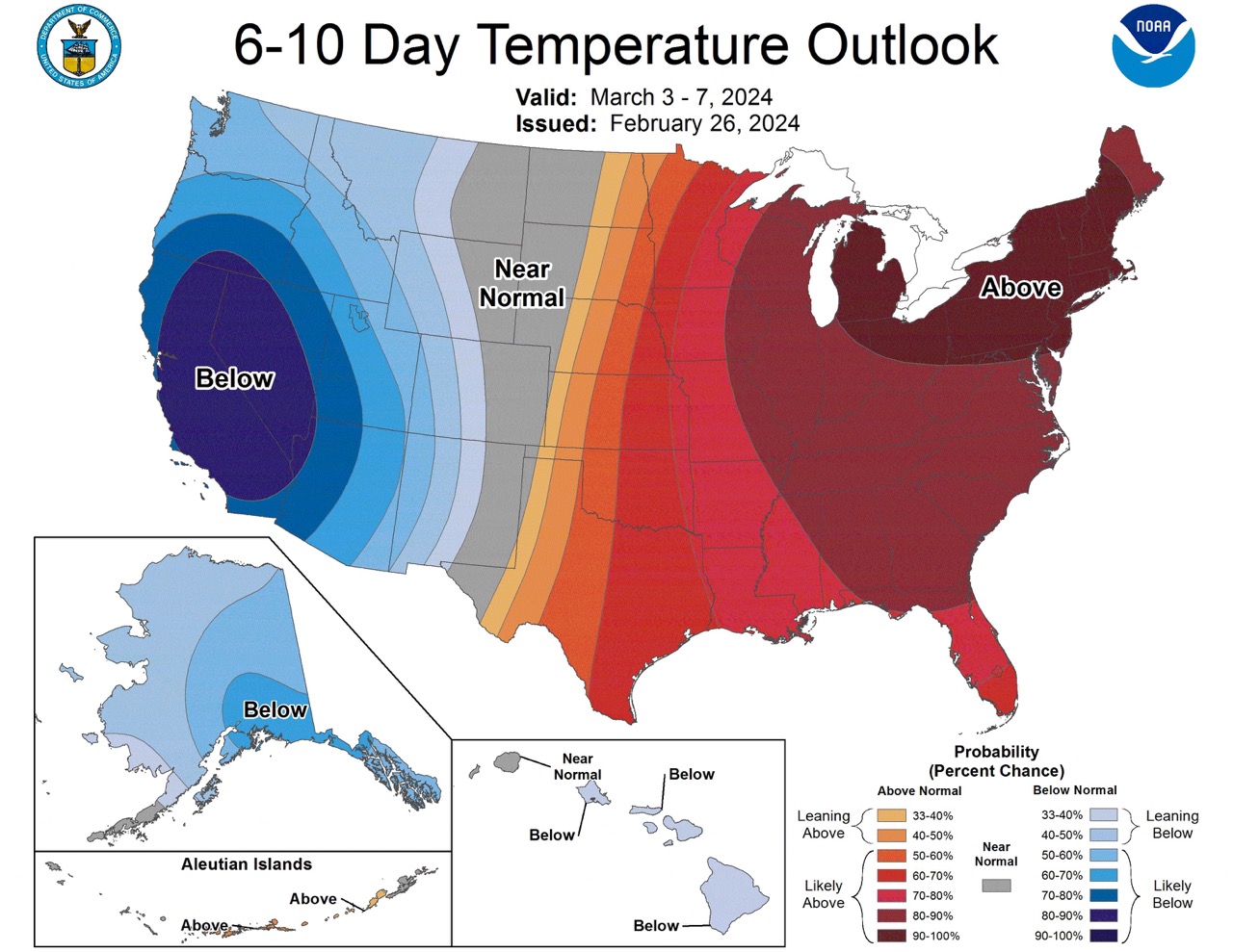
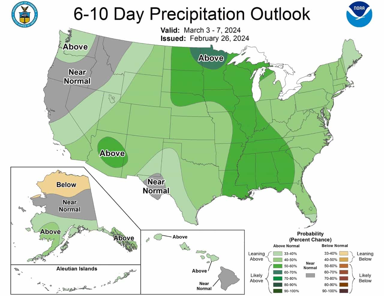
6-10 Day Outlook (Mar 03 – 07, 2024):
Temperature:
- Below Normal: Mainland Alaska, Southeast Alaska, Western CONUS (California to Rocky Mountains)
- Above Normal: Central Aleutians, Eastern Great Plains to Atlantic Coast
- Near to Below Normal: Hawaii
Precipitation:
- Above Normal: Eastern Aleutians, Southern Mainland Alaska, Southeast Alaska, Pacific Northwest, Southern California, Southwest, Northern Plains, Upper Mississippi Valley, Eastern CONUS
- Below Normal: Northern Mainland Alaska
Most Likely Snow Areas:
- Northern Mainland Alaska
- Pacific Northwest
- Northern Plains
- Upper Mississippi Valley
- Eastern CONUS
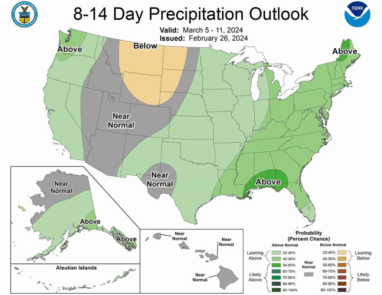
8-14 Day Outlook (Mar 05 – 11, 2024):
Temperature:
- Below Normal: Mainland Alaska, West CONUS (Pacific coast to the Rocky Mountains)
- Above Normal: Eastern Great Plains to Atlantic Coast
- Near Normal: Aleutians, Southern Alaska Panhandle, Hawaii
Precipitation:
- Above Normal: Eastern Aleutians, Southern Mainland Alaska, Southeast Alaska, Pacific coast of CONUS, Eastern Southwest, Central Plains, East CONUS
- Below Normal: Northern Mainland Alaska, Northern High Plains
Most Likely Snow Areas:
- Northern Mainland Alaska
- Pacific coast of CONUS
- Eastern Southwest
- Central Plains
- East CONUS
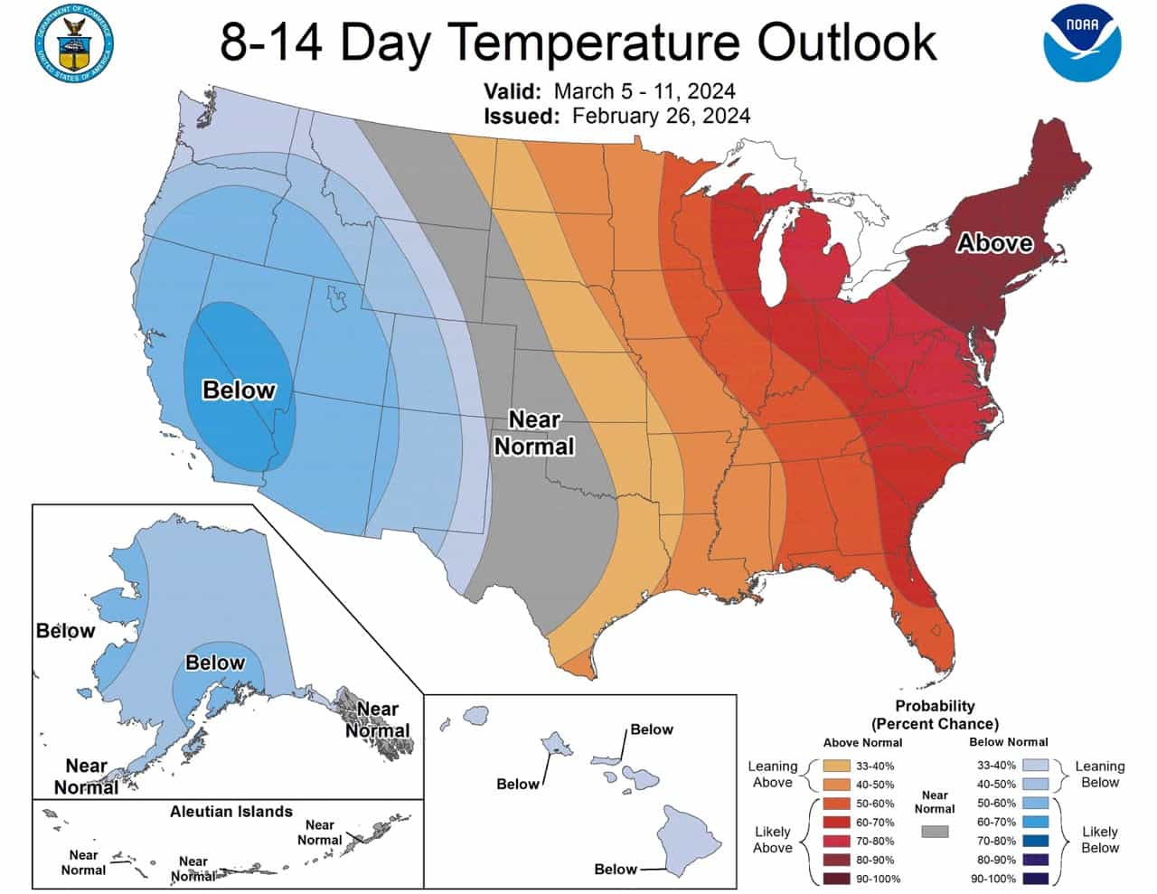
6-10 DAY OUTLOOK FOR MAR 03 - 07 2024

Today’s model forecasts are in very good agreement on the predicted mid-level
circulation pattern over the forecast domain during the 6-10 day period.
Ensemble mean solutions from the GEFS, ECMWF and Canadian models predict a
positive 500-hPa height anomaly over the northwestern Pacific and the Aleutian
Islands. Overall, today’s ensemble means predict mostly negative 500-hPa height
anomalies over most of Mainland Alaska and Southeast Alaska, under
northwesterly mid-level flow. A broad trough extends from western Canada into
the western and central CONUS in most model forecasts, with a much amplified
positive 500-hPa height anomaly over eastern North America, centered near
Maine, in all ensemble means and the manual blend of 500-hPa height forecasts.

Below normal temperatures are favored for Mainland Alaska and likely for
Southeast Alaska, under anomalous northerly flow. Above normal temperatures are
favored for most of the central Aleutians, under a positive 500-hPa height
anomaly. Below normal temperatures are very likely for much of the western
CONUS, from the Pacific coast to the Rocky Mountains, under the predicted
trough. Probabilities for below normal temperatures exceed 80 percent for much
of California and the western Great Basin. Above normal temperatures are likely
from generally the eastern Great Plains to the Atlantic. Probabilities for
above normal temperatures exceed 80 percent for most of the eastern Contiguous
U.S. (CONUS) and exceed 90 percent of most of the eastern Great Lakes region
and Northeast. Near to below normal temperatures are slightly favored for
Hawaii, with predicted cyclonic flow and potentially increased cloudiness.

The predicted circulation pattern over Alaska favors above normal precipitation
from the eastern Aleutians across southern Mainland Alaska and Southeast
Alaska, while below normal precipitation is slightly favored for northern
Mainland Alaska. Predicted onshore flow slightly favors above normal
precipitation for parts of the Pacific Northwest. Above normal precipitation is
favored from Southern California and the Southwest northeastward into the
Northern Plains and the Upper Mississippi Valley, ahead of the predicted
trough. Probabilities for above normal precipitation are also enhanced for the
eastern CONUS, ahead of the broad mid-level trough and with southerly surface
flow. Near to above normal precipitation is slightly favored for Hawaii, with
predicted cyclonic flow.

The official 6-10 day 500-hPa height blend consists of 40% of Today's 0z GFS
Ensemble Mean centered on Day 8, 40% of Today's 0z European Ensemble Mean
centered on Day 8, and 20% of Today's 0z Canadian Ensemble Mean centered on Day
8


FORECAST CONFIDENCE FOR THE 6-10 DAY PERIOD: Above average, 4 out of 5, with
very good agreement on the predicted 500-hPa height pattern, and high
probabilities in the temperature tools, offset by some differences and weaker
probabilities in the precipitation tools.

8-14 DAY OUTLOOK FOR MAR 05 - 11 2024

Dynamical models continue to be in good agreement on the predicted mid-level
circulation pattern during the 8-14 day period, showing some evolution of the
mean pattern for the 6-10 day period. A positive 500-hPa height anomaly
persists over the North Pacific and Aleutians during the 8-14 day period.
Negative 500-hPa height anomalies continue over Mainland Alaska into week 2 in
the ensemble mean forecasts. However, the flow over Southeast Alaska is less
northerly and more southwesterly in the week-2 period. A predicted trough over
the western CONUS deamplifies somewhat in the week-2 period relative to the
6-10 day period, while broadening over the central CONUS. A positive 500-hPa
height anomaly persists in dynamical model forecasts over the eastern CONUS.

Below normal temperatures continue to be favored over Mainland Alaska in week
2, under primarily negative 500-hPa height anomalies, while near normal
temperatures are favored for the Aleutians and the southern Alaska Panhandle.
Below normal temperatures are likely in week 2 over most of the West from the
Pacific coast to the Rocky Mountains, under a predicted trough. However,
probabilities for below normal have decreased, due to the predicted
deamplification of negative 500-hPa height anomalies. Above normal temperatures
are most likely further east over the CONUS, from parts of the eastern Great
Plains to the Atlantic coast, under continued positive 500-hPa height
anomalies. Below normal temperatures are slightly favored for Hawaii,
consistent with the automated temperature blend.

Above normal precipitation continues to be favored from the eastern Aleutians
across southern Mainland Alaska and Southeast Alaska, consistent with most
dynamical model precipitation tools. Near normal precipitation is favored over
northern Mainland Alaska, where dynamical model tools are less consistent in
week 2. Above normal precipitation continues to be slightly favored along the
Pacific coast of the CONUS, ahead of onshore flow. Below normal precipitation
is slightly favored over the northern High Plains, supported by
reforecast-calibrated precipitation forecasts from the GEFS and ECMWF. Above
normal precipitation is slightly favored for eastern areas of the Southwest
extending northeastward across most of the the Central Plains into the East in
week 2, consistent with a consensus of dynamical model precipitation tools.
Near normal precipitation is favored for Hawaii in week 2 as precipitation
signals weaken.

The official 8-14 day 500-hPa height blend consists of: 40% of Today's 0z GFS
Ensemble Mean centered on Day 11, 40% of Today's 0z European Ensemble Mean
centered on Day 11, and 20% of Today's 0z Canadian Ensemble Mean centered on
Day 11


FORECAST CONFIDENCE FOR THE 8-14 DAY PERIOD: About average, 3 out of 5, with
good agreement on the overall predicted 500-hPa height pattern, and high
probabilities in the temperature tools, offset by uncertainties associated with
the deamplification of the mid-level height anomalies, and further differences
and weak probabilities in the precipitation tools.

FORECASTER: D Collins