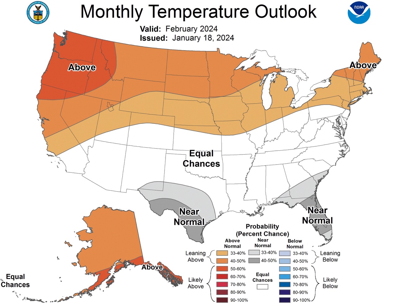
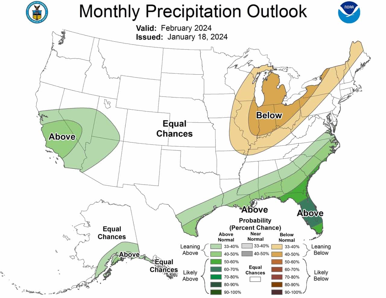
The NOAA recently released its outlook for February. For skiers or those seeking snow, the above-normal precipitation in regions like California, Nevada, Utah, and Arizona might be favorable for skiing conditions, especially in higher altitudes where temperatures remain cold enough for snow. However, the warmer temperatures in the Pacific Northwest and Alaska might limit snowfall or lead to faster melting. The below-normal precipitation in the Northeast and Great Lakes regions might mean less snowfall than usual in these traditionally snowy areas.
Below is an AI generated simplified summary, and also the full discussion from the NOAA for those who understand meteorological language.
Alaska
- Temperature: Above normal temperatures expected over all of Alaska, with higher chances for the south coast and Southeast Alaska.
- Precipitation: Above normal precipitation is likely for the south coast of Mainland Alaska and the northern Alaska Panhandle.
Pacific Northwest (U.S.)
- Temperature: High probability of above normal temperatures, especially in the Pacific Northwest.
California, Nevada, Utah, Arizona
- Temperature: Not specifically mentioned, but these regions often follow trends similar to the Pacific Northwest.
- Precipitation: Above normal precipitation is favored, particularly in Central and Southern California, extending northeastward into parts of Nevada, Utah, and Arizona.
Southeastern U.S. (Including Florida)
- Temperature: Enhanced probabilities of near-normal temperatures in parts of the Southeast.
- Precipitation: Above normal precipitation is likely, especially in the Gulf Coast and Florida Peninsula.
Central Mississippi Valley, Ohio Valley, Eastern Great Lakes, Northern New England
- Precipitation: Below normal precipitation is favored in these regions.
General Observations
- The forecast is largely influenced by a strong El Niño pattern, which typically affects temperature and precipitation patterns across North America.
- The forecast also considers various models and factors like sea surface temperature anomalies, wind patterns, and recent climate trends.
Below is the full discussion from the NOAA:
30-DAY OUTLOOK DISCUSSION FOR FEBRUARY 2024

The February 2024 monthly temperature and precipitation outlooks are made with
strong current El Niño climate conditions. The most recent weekly and seasonal
Niño 3.4 sea surface temperature (SST) anomalies are both at +1.9 degrees
Celsius. SST anomalies over the central and east-central equatorial Pacific
Ocean have remained steady over the last month, while positive SST anomalies
over the far eastern equatorial Pacific have weakened slightly. In recent
weeks, lower level wind anomalies at 850 hPa were westerly over the
east-central equatorial Pacific Ocean, while upper level wind anomalies at 200
hPa were easterly over the east-central and eastern equatorial Pacific Ocean.
Negative outgoing longwave radiation (OLR) anomalies are present near the Date
Line and north of the equator over the eastern Pacific Ocean, indicating
anomalously enhanced convection. These ocean and atmosphere conditions indicate
that the ongoing strong El Niño is well coupled to the atmosphere. El Niño
remains a primary driver of temperature and precipitation patterns over North
America in the near future and in the February temperature and precipitation
outlooks. On subseasonal timescales, the Madden Julian Oscillation (MJO) is
active in phase 4 with enhanced convection over the Maritime Continent, with
dynamical model forecasts indicating that the MJO will propagate eastward into
the western Pacific in the next couple weeks. Lagged composites indicate that
this active MJO would increase temperatures over the eastern United States in
the next couple weeks, before returning to potentially cooler temperatures,
especially over the Northeast, in early February. Impacts of the MJO were
generally only considered in the February monthly outlook through dynamical
model forecasts for the week 3-4 period that overlap with the first half of
February.

The February temperature and precipitation outlooks were based primarily on a
skill-weighted consolidation of dynamical model forecasts and a combined
consolidation of the statistical and dynamical model forecasts. Dynamical model
forecasts for the month of February are from the North America Multimodel
Ensemble (NMME). In addition, the full consolidation includes a consolidation
of the statistical models: the Canonical Correlation Analysis (CCA), the
Constructed Analog (CA), and an ENSO OCN tool, that combines the impact of
ENSO, based on the CPC SST consolidation predicted median Niño 3.4 SST anomaly,
with the Optimum Climate Normal (OCN) representing decadal trends . Daily
initialized forecasts from the NCEP CFSv2 dynamical model, the most recent
ECMWF and GEFS dynamical model forecasts for the week 3-4 period that overlaps
the beginning of the month of February, and a statistical multivariate linear
regression (MLR) forecast for the first half of February using the current Niño
3.4 and MJO indices as predictors, were also considered. Recent boundary
conditions, including coastal SSTs, snow cover anomalies, and soil moisture
anomalies, were additional factors considered.

The February temperature outlook favors above normal temperatures over all of
Alaska, consistent with dynamical model guidance and the monthly temperature
consolidation. Above normal temperatures are more likely for the south coast of
Mainland Alaska and Southeast Alaska, consistent with canonical El Niño
impacts. Above normal temperatures are favored across the northern tier of the
contiguous U.S. (CONUS), supported by the consolidation of statistical and
dynamical forecast tools. Probabilities for above normal temperatures exceed 50
percent over the Pacific Northwest, due to strong signals  in the NMME
consolidation. Equal chances (EC) of below, near and above normal temperatures
are indicated in the February outlook across much of the southern tier of the
CONUS, due to conflicting signals  from El Niño impacts and dynamical models .
The outlook indicates enhanced probabilities of near-normal temperatures for
parts of southeastern New Mexico, most of southern Texas, and for parts of the
Southeast, consistent with the consolidation forecast and NMME probabilities.
For the Southeast, decadal temperature trends  are positive, while negative
temperature anomalies are correlated with El Niño conditions.

The February precipitation outlook favors above normal precipitation for much
of the south coast of Mainland Alaska and the northern Alaska Panhandle,
supported primarily by dynamical model forecasts from the NMME and correlation
of seasonal precipitation to Niño 3.4 SST anomalies. Above normal precipitation
is favored from Central and Southern California northeastward into parts of
Nevada, Utah and Arizona, consistent with canonical El Niño impacts, dynamical
model forecasts from CFSv2 for February, and dynamical model forecasts from the
ECMWF and GEFS models for the first half of February. Negative decadal
precipitation trends  damp probabilities for above normal precipitation over
this region. Above normal precipitation is also favored along the Gulf Coast
and likely for parts of the Southeast, including the Florida Peninsula, where
correlations of precipitation and the Niño 3.4 SST index are greatest. Below
normal precipitation is favored from the Central Mississippi Valley, across the
Ohio Valley, the eastern Great Lakes region, and over northern areas of New
England, consistent with the CFSv2 model forecasts for February, and ECMWF and
GEFS model forecasts for the first half of February.