Yesterday, the NOAA released its outlook for May 2024. The outlook predicts above-normal temperatures for the Northwest, the eastern half of the country, and southeastern Alaska, with mixed signals for precipitation but a general tilt towards above-normal rainfall in the central and southern regions and below-normal precipitation in the Southwest and Northwest.
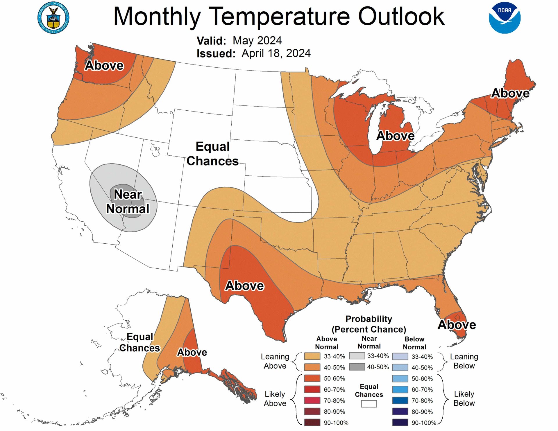
Temperature Outlook for May 2024
- Northwest & Southeastern Alaska: Above normal temperatures are expected, with the highest chances in Washington, the Great Lakes, northern New England, southeastern New Mexico, southwestern Texas, the southern tip of Florida, and southeastern Alaska.
- California, Arizona, Nevada, and Utah: Near normal temperatures are anticipated.
- Southwest: Confidence is high for above-normal temperatures due to low soil moisture and forecasted dry conditions.
- Western Alaska: Mixed signals, but a transition to warmer temperatures is expected in the southeast part of the state.
- Southern California & Four Corners: There are equal chances of above, near, or below normal temperatures due to mixed model signals and observed sea surface temperatures.
- Gulf States: Above-normal temperatures are likely, especially in coastal regions, but recent high rainfall and soil moisture may dampen the chances.
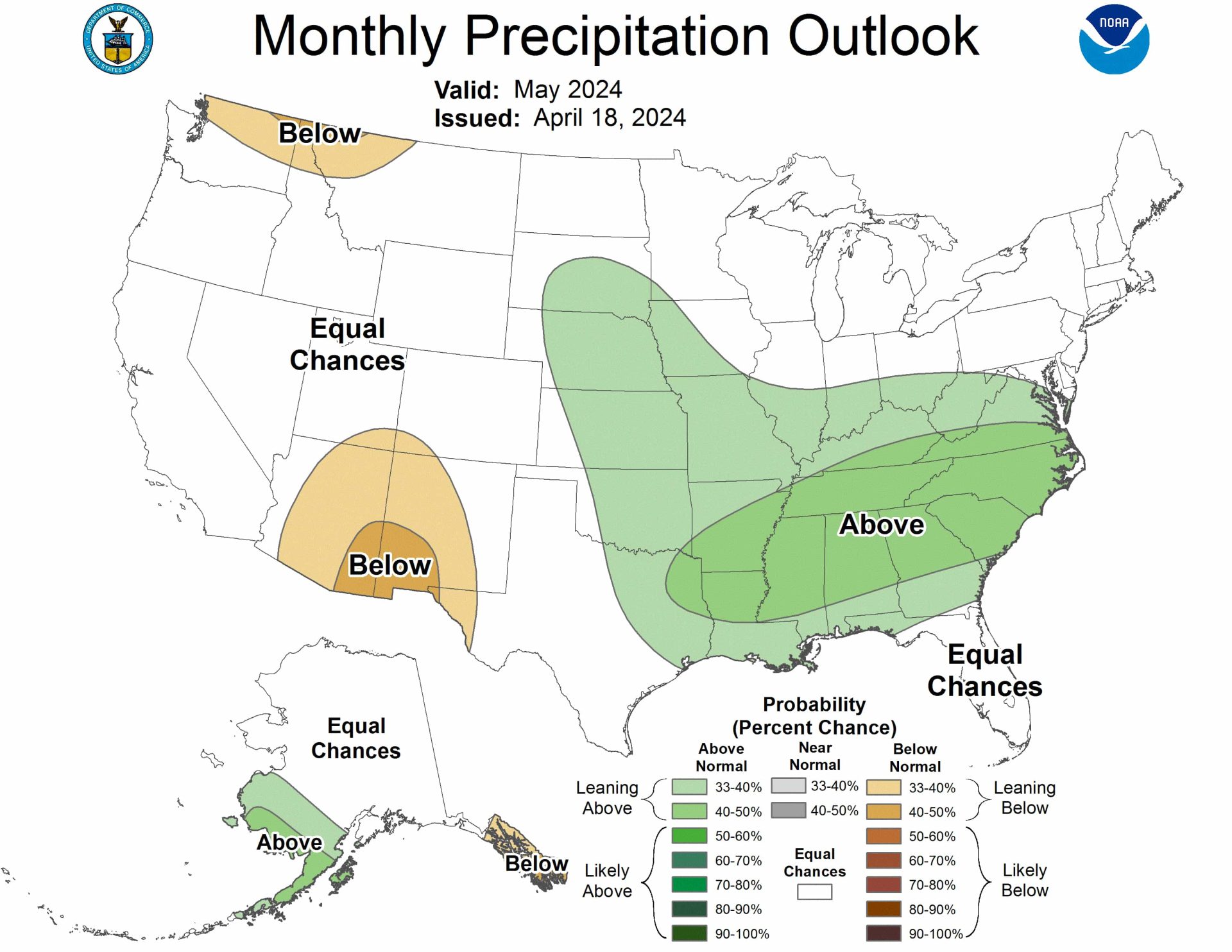
Precipitation Outlook for May 2024
- Central & Southern CONUS: Above-normal precipitation is favored in the Mid-Atlantic, Middle Mississippi, and Ohio Valley regions, with some influence from El Niño and enhanced soil moisture.
- Southeast: A tilt toward above-normal precipitation is supported by lingering El Niño effects.
- Great Lakes: Equal chances of above, near, or below normal precipitation due to weak or inconsistent model signals and opposing influences of trends and El Niño.
- Mississippi & Ohio Valley: A weak tilt toward above-normal rainfall is indicated.
- Southwest: Below-normal precipitation is expected by mid- to late-May, despite some early signals for above-median precipitation.
- Northwest: Odds are tilted toward below-normal precipitation due to El Niño influences and trends.
- Alaska: Above-normal precipitation is favored in the southwest, while southeastern Alaska has a weak tilt toward below-normal precipitation due to El Niño’s expected influence.
The full NOAA discussion is below:
Prognostic Discussion for Monthly Outlook
NWS Climate Prediction Center College Park MD
830 AM EST Thu Apr 18 2024


30-DAY OUTLOOK DISCUSSION FOR MAY 2024

El Niño conditions are currently observed, and equatorial sea surface
temperatures (SSTs) are above average across the much of the central and
eastern equatorial Pacific Ocean, reaching 0.9 degrees Celsius above normal in
the Niño3.4 region, 0.6 degrees Celsius above normal in the Niño3 region, but
have decreased to -0.2 degrees Celsius below normal in the Niño1+2 region.
Above average SSTs have weakened across most of the equatorial Pacific Ocean in
the last 4 weeks, and tropical Pacific atmospheric anomalies are weakening as
well. Given the weakening signals in the equatorial Pacific, a transition from
El Niño to El Niño Southern Oscillation (ENSO)-neutral conditions is likely by
April-May-June 2024. The Madden Julian Oscillation (MJO) has continued to
weaken recently and though there has been eastward propagation in the past
week, the amplitude has dropped. Dynamical model forecasts of the Realtime
Multivariate MJO (RMM) index through close to the end of April are weak and
incoherent due to an emerging low-frequency feature over the western Indian
Ocean which appears to be interfering with the MJO. While we may see some
lingering impacts to temperature and precipitation due to El Niño, the
influence is expected to weaken throughout the next few months. Moreover, the
weak amplitude of the MJO does not support much of a teleconnection response
over the Contiguous United States (CONUS). As such, the May 2024 Temperature
and Precipitation Outlooks are mainly supported by the lingering influence of
El Niño, local SST anomalies, influence of soil moisture anomalies, dynamical
model guidance from the North American Multi-Model Ensemble (NMME), Copernicus
model suite (C3S), and the Climate Forecast System version 2 (CFSv2), as well
as statistical models that include the influence of trend and ENSO. The Week
3-4 Outlook for the early part of May was also considered, as was the expected
evolution from the Week 2 forecast period.


The May 2024 Temperature Outlook favors above normal temperatures over the
Northwest, much of the eastern half of the CONUS, and southeastern Alaska. A
relatively small region of near normal temperatures is indicated over parts of
California, Arizona, Nevada, and Utah. The highest probabilities of above
normal temperatures, 50 to 60 percent, are located over Washington, the Great
Lakes, northern New England, southeastern New Mexico and parts of southwestern
Texas, the southern tip of Florida, and southeastern Alaska. Probabilities are
enhanced over these regions given good consistency among tools on above normal
probabilities. Decadal trends also support above normal probabilities over the
northwest and northern New England. Anomalously warm Great Lakes temperatures
provide additional support for above normal probabilities over the region.
Lower than normal soil moisture along with forecasted below normal rainfall in
dynamical models, and strong probabilities for above normal temperatures in
recent CFSv2 forecasts of May temperatures adds to confidence over the
Southwest. Signals were more mixed over western Alaska given cooler SST
anomalies and sea ice, but NMME and C3S favor a transition to warmer
temperatures over the southeast part of the state. Near normal and equal
chances of above, near and below normal temperatures (EC) are indicated over
southern California and the Four Corners where there are observed coastal below
normal to neutral SSTs, near normal temperature forecasts from NMME and C3S,
and a below normal CFSv2 temperature forecast. While tools tilt toward above
normal temperatures over the Gulf States (particularly coastal regions),
partially supported by warmer Gulf of Mexico SSTs, high amounts of recent
rainfall over eastern Texas and Louisiana have resulted in high soil moisture,
and as such probabilities are still above normal but damped. EC is favored
where models were inconsistent and/or where there was a lack of support from
statistical tools.


There is more uncertainty in the May 2024 Precipitation Outlook than the
Temperature Outlook, as evidenced by lower overall probabilities and larger
areas of EC. Models favor above normal precipitation over parts of the central
and southern CONUS, including parts of the Mid-Atlantic, Middle Mississippi and
Ohio Valley regions. Some lingering influence from El Niño further supports the
tilt toward above normal precipitation over the Southeast, as well as enhanced
soil moisture. Though El Niño can lead to below normal precipitation over the
Great Lakes, Middle Mississippi Valley, and Ohio Valley, this influence is
overshadowed by above normal precipitation trend. EC is indicated over the
Great Lakes where models had weak or inconsistent signals and trend and El Niño
influence are opposite. However, over the Mississippi and Ohio Valley regions
C3S and NMME favored above normal rainfall and thus a weak tilt toward above
normal is indicated. Dynamical models and dry soil moisture led to the favored
probability of below normal precipitation over parts of the southwest, which is
also indicated in the Seasonal Outlook for May-July 2024. However, this is at
odds with the recent Weeks 3-4 Precipitation Outlook for early May that tilted
weakly toward above median precipitation. We expect below normal precipitation
 over the region by mid- to late- May. Tools were again mixed over the
northwest, but influences from El Niño and trend tilt the odds toward below
normal. Finally, over Alaska, above normal precipitation is favored over the
southwest where there has been recent above normal precipitation, with a weak
tilt toward below normal precipitation over southeastern Alaska due to expected
influence from El Niño.
FORECASTER: Johnna Infanti

The climatic normals are based on conditions between 1991 and 2020, following
the World Meteorological Organization convention of using the most recent 3
complete decades as the climate reference period. The probability anomalies for
temperature and precipitation based on these new normals better represent
shorter term climatic anomalies than the forecasts based on older normals.

An updated monthly outlook... for May will be issued on Tue Apr 30 2024

These outlooks are based on departures from the 1991-2020 base period.
$$