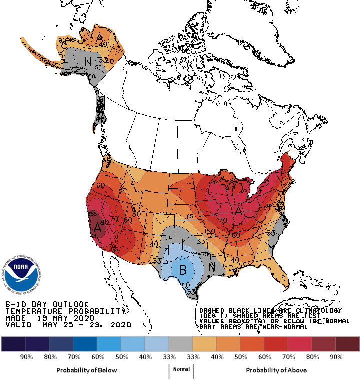
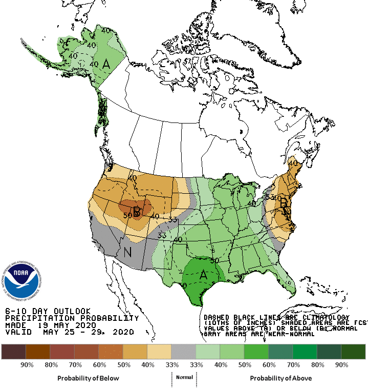
The NOAA just released their outlook for the final week of May. The majority of the United States looks like they’re in for warmer than normal temperatures (Denver just had a record-breaking daily high yesterday). Most of the west can expect below average or normal precipitation, whereas the central and eastern US can expect it to be wetter.
Full forecast discussion below:
Today’s temperature forecast shows increased above normal temperature
probabilities highlighted over much of the CONUS. Due to a potential mid-level
low over the Southern Plains, below normal temperature probabilities are
increased over parts of the region as a result of increased cloud cover and
elevated rainfall chances. The highest probabilities for above normal
temperatures are over the Northeast and Southwest, collocated with the highest
height anomalies. Near normal temperatures are favored for the eastern
Carolinas, consistent with the ECMWF and GEFS reforecast tools and developing
easterly flow off the Atlantic favoring relatively cooler temperatures. Despite
the troughing forecast over western Alaska and the Bering Sea, above normal
temperatures are forecast across most of the state due to increased southerly
flow and above average sea surface temperatures. Although cooler conditions are
probable across the southern Mainland and the Panhandle initially, as a result
of troughing and increased cloud cover, ridging and warmer temperatures
arriving later in the period favor a near normal temperature forecast for the
period overall.

Probabilities for above normal precipitation are elevated over the central
CONUS due to the potential for periodic shortwave troughing over the West and
enhanced frontal system activity over the Great Plains and Mississippi Valley.
Southerly flow out of the Gulf of Mexico also enhances precipitation chances
across the southern tier from Texas to Florida. There is a bit more clarity
compared to yesterday regarding enhanced rainfall over the Southern Plains
resulting from a mid-level low over the region. While the ECMWF ensemble now
shows less rainfall compared to yesterday, the GEFS has increased its rainfall
totals. Both model ensembles depict 1-2 inches of rain over eastern and central
Texas for the period, and as a result above normal precipitation probabilities
are increased to above 50% for this area, with the bulk of the rainfall favored
on days 6 and 7. The ECMWF expands these higher totals into Louisiana as well,
but the GEFS still keeps the heaviest rain back to the west over Texas.
Probabilities for below normal precipitation are increased over parts of the
Northeast, mid-Atlantic, and the West where higher heights are forecast.
Enhanced above normal precipitation probabilities are favored for most of
Alaska given the troughing initially forecast over the Bering Sea and
associated unsettled weather conditions.