NOAA: “Potentially Strong System” with “Atmospheric River” Possible in CA This Weekend

WeatherBrains | | Post Tag for WeatherWeather
Low Pressure Systems and water vapor headed to the West Coast this weekend? We hope so. image: noaa, today

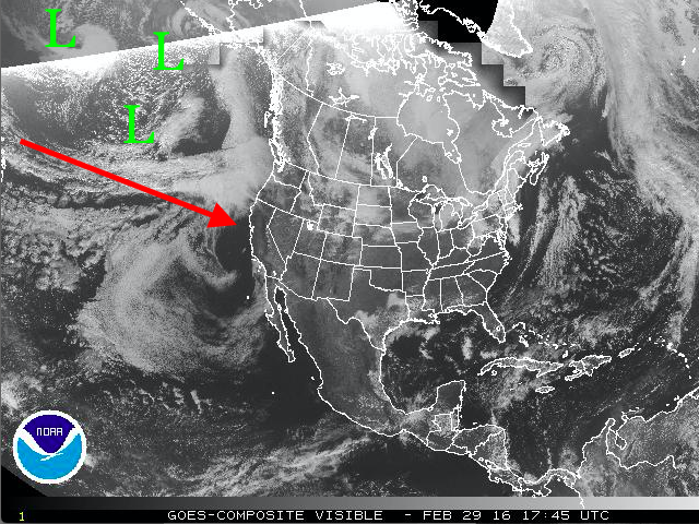
This is what NOAA is saying about this weekend’s storm in California today:

  • “potentially strong system”
  • “atmospheric river”
  • “Snow levels will start high, above 7000 feet before crashing behind the cold front late Sunday”
  • “The active weather pattern looks to continue through the middle of next week, and possibly into the middle of March”
  Sunday looks like the big day with a potentially strong system. Both the 
  GFS/EC show a potent system moving in with rain/snow and strong 
  winds. The GFS does not look as impressive for precip east of the 
  crest due to more south winds as the atmospheric river makes 
  landfall. However, the EC has more favorable SW winds and more 
  significant precip east of the crest. Either way, travel impacts 
  are likely Sunday with this system. Snow levels will start high, 
  above 7000 feet before crashing behind the cold front late Sunday. 
  The active weather pattern looks to continue through the middle of 
  next week, and possibly into the middle of March." - NOAA Reno, NV today
"Outside of a few showers Thursday, weak systems will be deflected to our north this week. But we have good news! The storm track looks to shift south to NorCal this weekend!" - NOAA Sacramento, CA today
“Outside of a few showers Thursday, weak systems will be deflected to our north this week. But we have good news! The storm track looks to shift south to NorCal this weekend!” – NOAA Sacramento, CA today
Possible CA storm scenarios. Both scenarios are looking good for CA. image: noaa, today


"Precipitation has been confined to Northern California and far Northern Nevada the last few days of February. Although, the first few days of March are forecast to be wetter. Weak systems will bring precipitation to Northern and Central California the next few days. Precipitation is forecast to become heavier and more wide spread and make it into Southern California this weekend with an upper level trough and good moisture plume into California." - NOAA, today
“Precipitation has been confined to Northern California and far Northern Nevada the last few days of February. Although, the first few days of March are forecast to be wetter. Weak systems will bring precipitation to Northern and Central California the next few days. Precipitation is forecast to become heavier and more wide spread and make it into Southern California this weekend with an upper level trough and good moisture plume into California.” – NOAA, today

This is looking very good for California and all of the Western USA.  We’ve got our fingers crossed tightly.

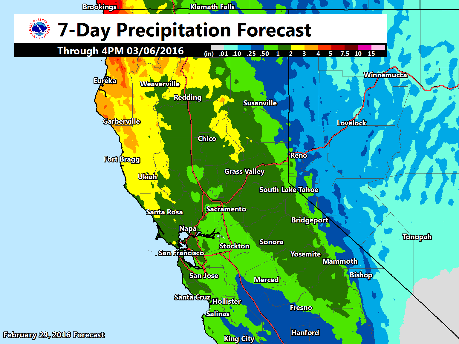
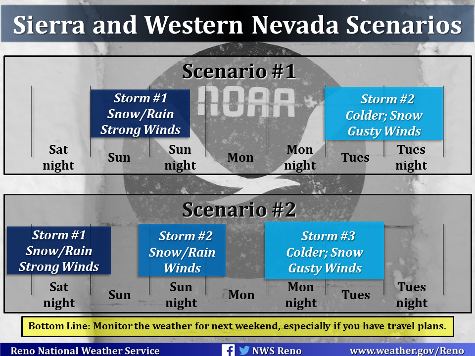
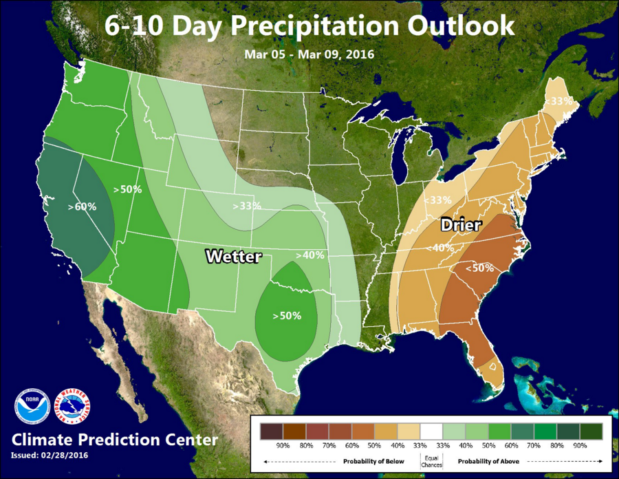
The above map is suggesting 1-2 feet of snowfall for the Lake Tahoe region by March 6th and the storm scenario timelines above both look great.

Confidence is increasing for a pattern change by next weekend, with some model simulations showing a rather stormy pattern developing. Although it is much too early to hammer down the finer details, it is early enough to give a heads up for the potential of travel impacts. Confidence is medium-high for seeing at least one decent storm between Sunday and Tuesday, but details such as snow/rain/wind magnitudes and timing are low confidence for now. Here are two scenarios for the storms next weekend based on the most recent simulations. Although there are breaks represented in the graphic between the storms for both scenarios, we highly recommend monitoring the weather through the week as the timing of these storms will likely change.” – NOAA Reno, NV today

6-10 day outlook looking good.
6-10 day outlook looking good for the West.
"Models continue to advertise a return to a wetter weather pattern beginning the end of this week and continuing into the 2nd week of March. How much rain and snow for NorCal? Too early to tell so stay tuned!" - NOAA Sacramento, CA yesterday
“Models continue to advertise a return to a wetter weather pattern beginning the end of this week and continuing into the 2nd week of March. How much rain and snow for NorCal? Too early to tell so stay tuned!” – NOAA Sacramento, CA yesterday

***

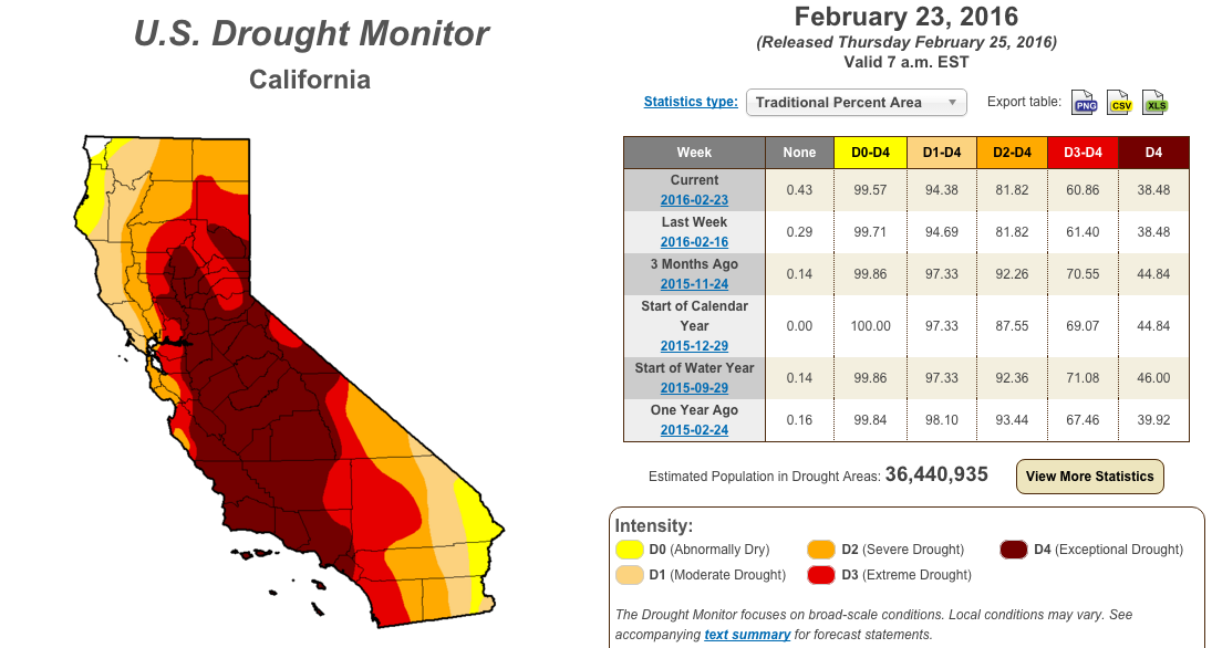
If this “rather stormy pattern” develops as NOAA is forecasting, we could be looking at one helluva Miracle March and we need it as the California drought has gone NO WHERE, yet…

***

"California's winter has been a mixed bag so far this winter. We've had two moderately wet months in Northern California, offset by a very dry February. The net result: NorCal is running a bit drier than normal on the water year." - NOAA Sacramento, CA today
“California’s winter has been a mixed bag so far this winter. We’ve had two moderately wet months in Northern California, offset by a very dry February. The net result: NorCal is running a bit drier than normal on the water year.” – NOAA Sacramento, CA today
Most of CA is currently in an Exceptional drought.
Most of CA is currently in an Exceptional drought right now.

***

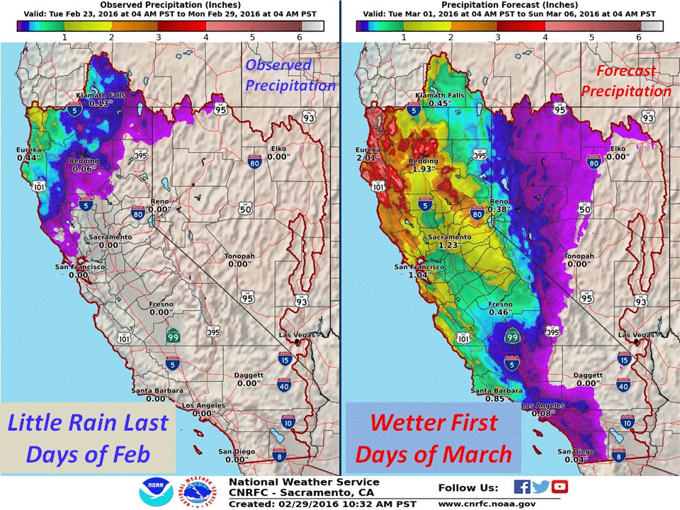
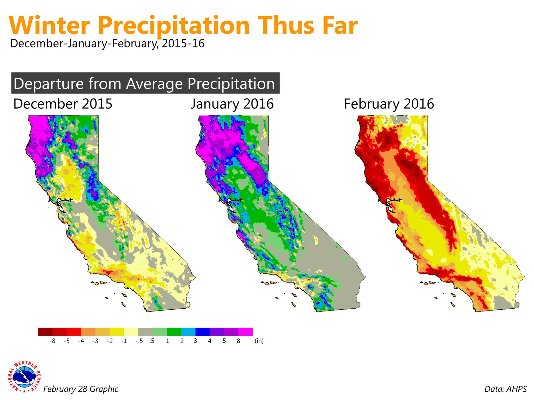
February was a total bust in California with record heat and only one storm that brought about 2-feet of snow.  That record heat will continue all week this week until this pattern change arrives this weekend.

“Another warm day in store for NorCal. A few high temperature records for‪#‎LeapDay‬ could be broken!” – NOAA Sacramento, CA today

Lets turn this thing around in back into a wet, nasty, snowy El Nino pattern for March & April in the USA!

***

Possible CA storm scenarios. image: noaa, today
Possible CA storm scenarios. Both of these scenarios are good.  image: noaa, today


Related Articles

Got an opinion? Let us know...