
“A powerful cold front will move through the Sierra and western Nevada on Tuesday and bring gusty winds and much colder temperatures. The winds will create dangerous boating conditions on Lake Tahoe and Pyramid Lake, strong crosswinds for travelers along highway 395 and interstate 580, and areas of blowing dust east of highway 395. After the cold front passes through Tuesday night, expect much colder temperatures and chances for rain and snow showers on Wednesday. “ – NOAA September 23rd, 2013
Lake Tahoe got it’s first snowstorm of the 2013/14 winter season last weekend. It was a very early snowfall for Tahoe. Right on the cusp between summer and fall (the equinox). Before that snow has time to completely melt away, here comes another snowstorm for Lake Tahoe, CA.
Right now, NOAA is saying that Tahoe will begin to see snow tonight/tomorrow morning with snow levels down to 6,500-feet. As the cold front pushed through on Wednesday evening, snow levels may drop as low as 5,000-feet! Up to a couple of inches of new snow above 7,000 with mainly a dusting lower down.

NOAA Update as of 6:04am PST, September 24th, 2013:
AS THE COLD FRONT PUSHES SOUTH TONIGHT, SHOWERS MAY REACH AS FAR
SOUTH AS RENO AND THE TAHOE BASIN, ALTHOUGH THE BETTER CHANCE FOR
LIGHT PRECIPITATION IS LIKELY TO REMAIN NORTH OF I-80. WHILE
COLDER AIR MASS WILL SPREAD ACROSS THE REGION, SNOW LEVELS SHOULD
REMAIN NEAR OR ABOVE 6500 FEET THROUGH WEDNESDAY MORNING ACROSS MOST
OF THE REGION AS 700 MB TEMPS RANGE FROM -4 TO -6 C. THE ONLY
EXCEPTION IS ACROSS FAR NORTHEAST CA-NORTHWEST NV WHERE SNOW
LEVELS MAY DROP TO 5000-5500 FEET.
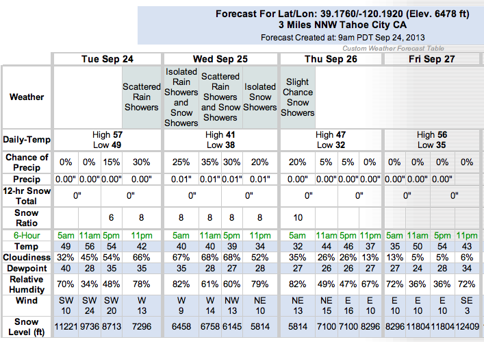
BY WEDNESDAY EVENING, THE LATEST GUIDANCE DEPICTS A SECONDARY
SHORTWAVE MOVING SOUTH ACROSS THE SIERRA, LEADING TO EVEN COOLER
CONDITIONS. BY THIS TIME, SNOW LEVELS COULD FALL TO NEAR 5000 FT
IN WESTERN NV NORTH OF HIGHWAY 50. HOWEVER, THE MOISTURE WILL
BECOME SHALLOWER AND MAY ONLY PRODUCE TRACE AMOUNTS OF
PRECIPITATION BY THE TIME THIS SHORTWAVE ARRIVES. THE BEST CHANCE
FOR LIGHT SNOW SHOWERS APPEARS TO BE SETTING UP ALONG AND WEST OF
HIGHWAY 89 FROM NORTHEAST CA AND WEST OF LAKE TAHOE DURING THE
LATE AFTERNOON AND EARLY EVENING, AS THE COLD POOL ALOFT MOVES
OVERHEAD. AT THIS TIME, THE FAST MOVEMENT OF THIS SHORTWAVE WILL
LIMIT SNOW AMOUNTS. LOCAL AMOUNTS AN INCH OR TWO MAY OCCUR ABOVE
7000 FEET, BUT LITTLE OR NO ACCUMULATION IS EXPECTED AT LAKE
LEVEL.
We are lovin’ this early season snow.
hopefully this is a trend