NOAA: “Up to 5-Feet of Snow Forecast for California by Tuesday” | Atmospheric River On Tap
WeatherBrains |
Share this article
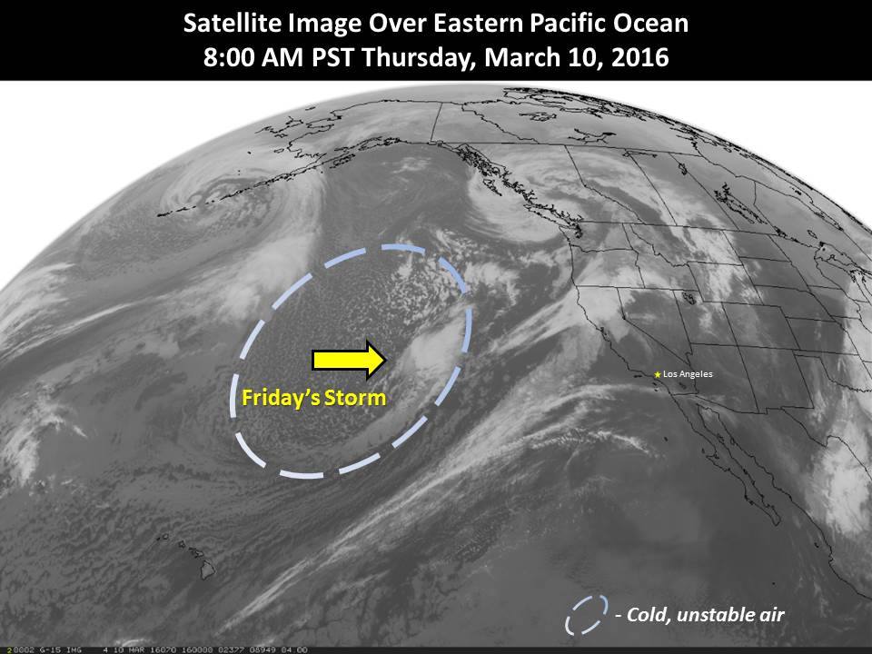
“Here’s the morning satellite view of our storm expected to arrive on Friday. There will likely be several hours of rain and isolated thunderstorms capable of gusty winds and small hail as this system moves across southern California. Most rainfall amounts will be in the 0.50 – 1 inch range with local amounts between 1-2 inches closer to the foothills and mountains. Heavier rainfall amounts are possible with thunderstorm activity. Snow levels will start out above 6000 feet Friday, but drop to less than 5000 feet Friday night and Saturday morning” – NOAA LA, CA today
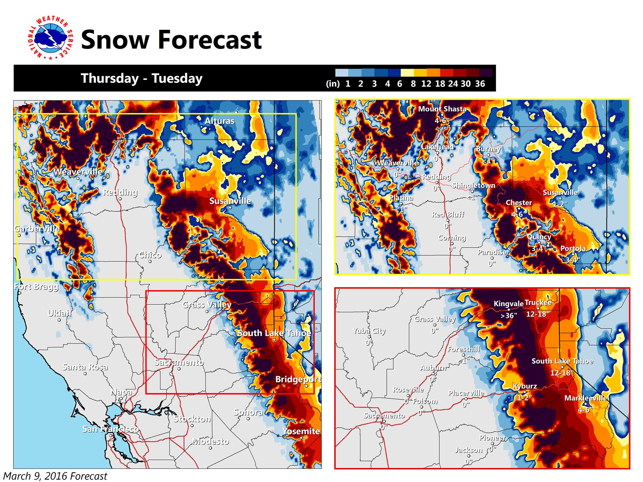
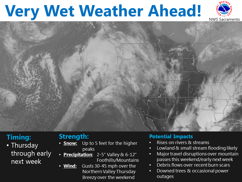
NOAA is forecasting 1-5 Feet of snow in California by Tuesday. An Atmospheric River will be unloading another “parade of storms” on CA.
“Mountain snow will pile up this weekend into early next week! 1 to 3 feet is possible above 5000 feet with up to 5 feet along higher peaks! ” – NOAA Sacramento, CA yesterday
Latest atmospheric river (AR) over the eastern Pacific Ocean aimed at northern California today. You can also see a large swath of moisture associated with another AR over the western Gulf of Mexico which is feeding heavy rain in the southern sections of the country.
(Video: “Latest atmospheric river (AR) over the eastern Pacific Ocean aimed at northern California today. You can also see a large swath of moisture associated with another AR over the western Gulf of Mexico which is feeding heavy rain in the southern sections of the country.” – NOAA LA, CA today)
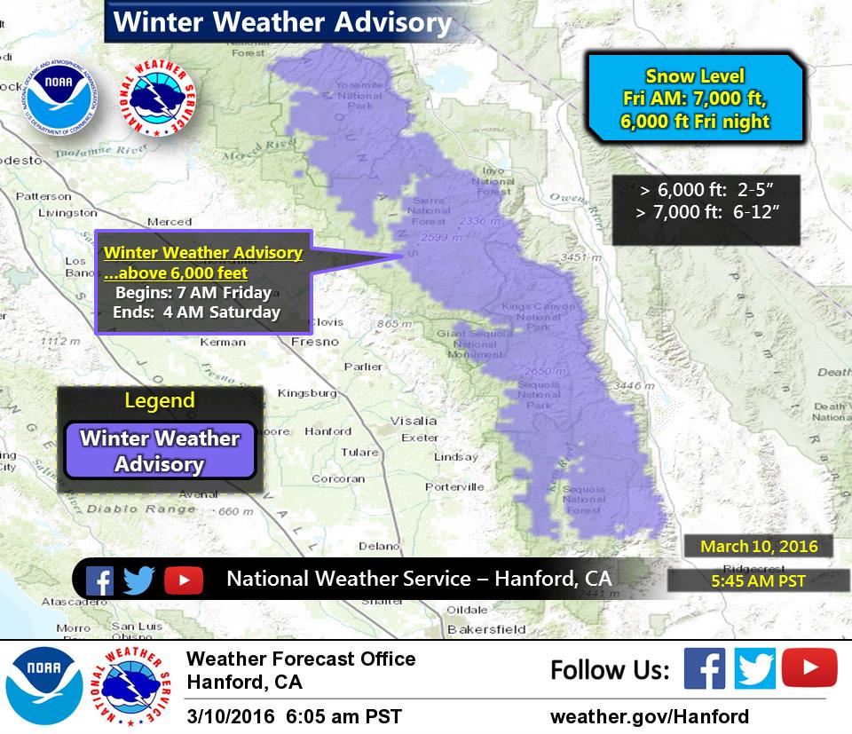
A Winter Weather Advisory is already in effect for the southern Sierra Nevada that calls for 6-12″ of snow on Friday night.
It’s on in California right now.
Miracle March is real…
CALIFORNIA SNOW FORECAST:
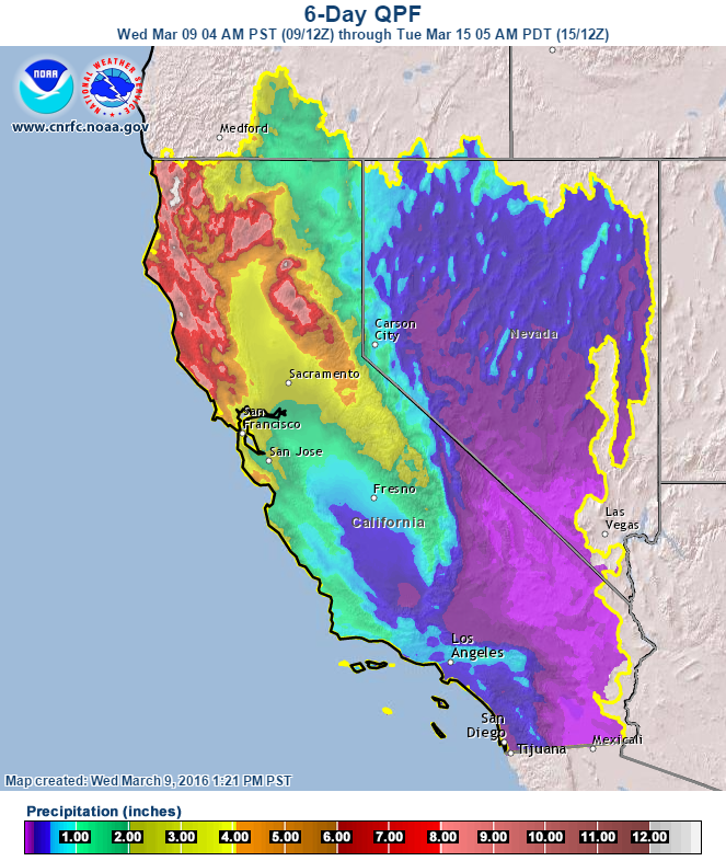
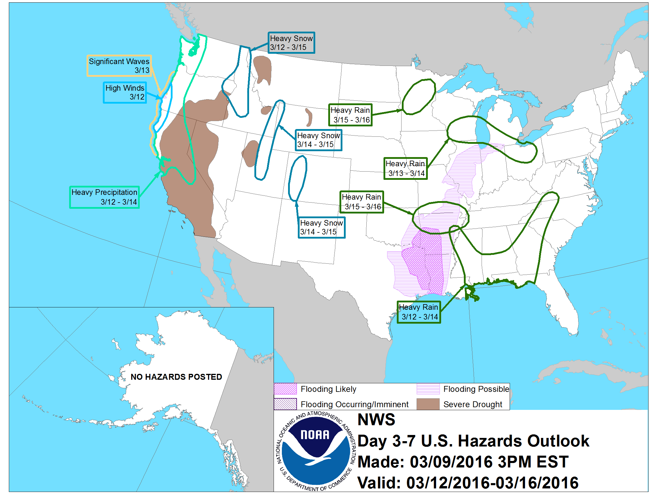
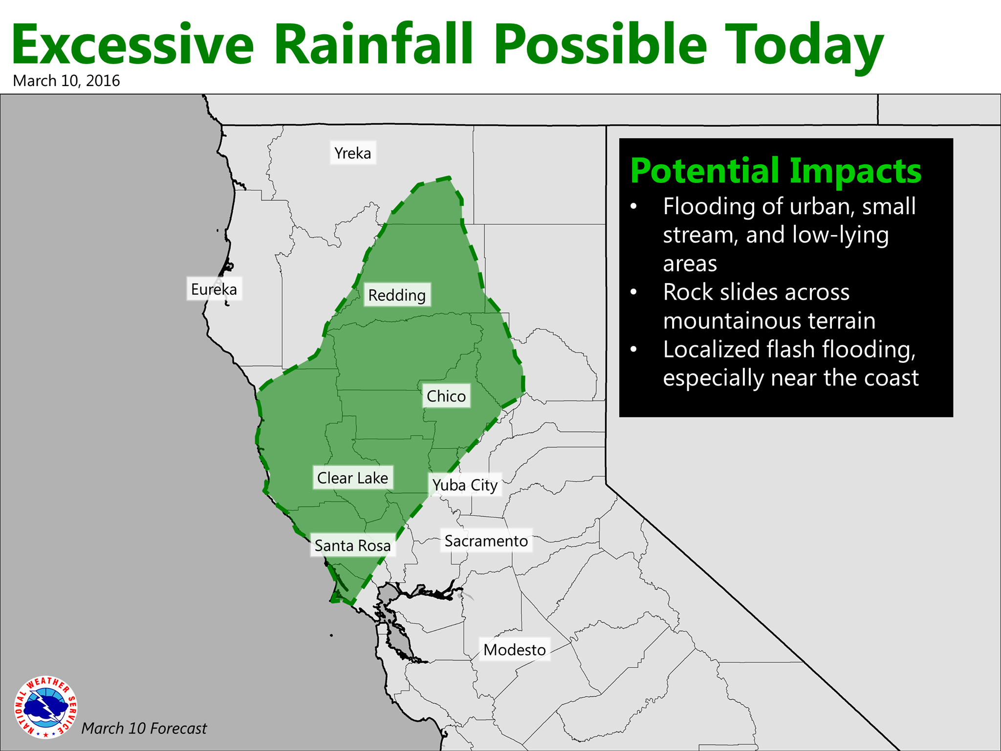
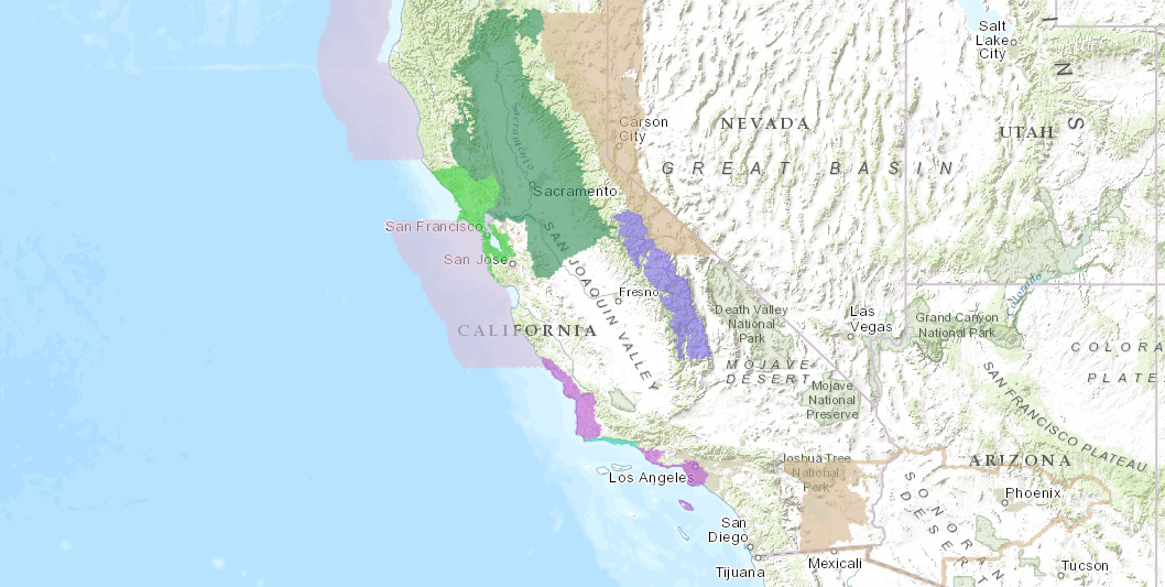
“Mountain snow will pile up this weekend into early next week! 1 to 3 feet is possible above 5000 feet with up to 5 feet along higher peaks! ” – NOAA Sacramento, CA yesterday“A parade of strong weather systems will move through Northern California Thursday through Tuesday of next week. Main impacts include heavy rain and heavy snow. Breezy to locally gusty winds are possible Thursday and this weekend. The upcoming wet pattern might result in increased runoff from heavy rain, leading to rises on many Northern California streams, rivers, and weir flows. Thus, low land, urban, and small stream flooding are likely. In addition, heavy snow combined with wind, will likely result in hazardous mountain travel and road closures.” – NOAA Sacramento, CA yesterday“Here’s our latest precipitation forecast for the storms expected through the upcoming weekend. Heaviest amounts will be over northern California (over the higher terrain… 5 to 10 inches locally to 12 inches). To check out river impacts… ” – NOAA LA, CA yesterday“A Winter Weather Advisory has been issued for the Southern Sierra Nevada above 6,000 feet from 7 am Friday through 4 am Saturday. Snow will begin above 7,000 feet early Friday morning, becoming heavy at times during the afternoon and early evening. The snow level will lower to around 6,000 feet during the evening, then diminishing snow showers late Friday night.” – NOAA Hanford, CA todayNOAA’s long range forecast calling for “Heavy Precipitation” for CA March 12-14th. image: noaa, today“A warm and wet weather system is moving through Northern California today. This system is expected to stall just north of Interstate 80, and could bring an extended period of heavy precipitation along a narrow corridor. Flooding of urban, small stream, and low-lying areas will be possible, along with rock slides across mountainous terrain.” – NOAA Sacramento, CA todayPURPLE = Winter Weather Advisory. GREEN = Flood Watch. image: noaa, today
WINTER WEATHER ADVISORY for SOUTHERN SIERRA:
URGENT - WINTER WEATHER MESSAGE
NATIONAL WEATHER SERVICE HANFORD CA
447 AM PST THU MAR 10 2016

CAZ096-097-102100-
/O.NEW.KHNX.WW.Y.0007.160311T1500Z-160312T1200Z/
SIERRA NEVADA FROM YOSEMITE TO KINGS CANYON-
TULARE COUNTY MOUNTAINS-
INCLUDING THE CITIES OF...SHAVER LAKE...YOSEMITE VALLEY...
CAMP NELSON...GIANT FOREST...JOHNSONDALE...LODGEPOLE
447 AM PST THU MAR 10 2016

...WINTER WEATHER ADVISORY IN EFFECT FROM 7 AM FRIDAY TO 4 AM PST
SATURDAY...

THE NATIONAL WEATHER SERVICE IN HANFORD HAS ISSUED A WINTER
WEATHER ADVISORY ABOVE 6000 FEET FOR SNOW AND WIND...WHICH IS IN
EFFECT FROM 7 AM FRIDAY TO 4 AM PST SATURDAY.

* SNOW ACCUMULATIONS...6 TO 12 INCHES ABOVE 7000 FEET...2 TO 5
  DOWN TO 6000 FEET.

* TIMING...SNOW WILL BEGIN ABOVE 7000 FEET EARLY FRIDAY
  MORNING...BECOMING HEAVY AT TIMES DURING THE AFTERNOON AND EARLY
  EVENING. SNOW LEVEL LOWERING TO AROUND 6000 FEET DURING THE
  EVENING. DIMINISHING SNOW SHOWERS LATE FRIDAY NIGHT.

* WINDS...SOUTHWEST 25 TO 35 MPH WITH GUSTS AROUND 50 MPH. HIGHER
  GUSTS NEAR THE CREST OF THE SIERRA.

* IMPACTS...DIFFICULT TRAVEL CONDITIONS...ESPECIALLY ABOVE 7000
  FEET. SLICK...SNOW COVERED ROADS. BLOWING AND DRIFTING SNOW.