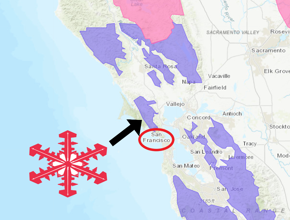
The National Weather Service has issued Winter Weather Advisories throughout the Bay Area. Some of which, are just over 10 miles from San Francisco, CA.
Talampais-Homestead Valley, CA is located just 12 miles from San Francisco. It sits at an elevation of 33 feet and snow is possible in the area on Tuesday.
Muir Woods National Monument is located just over 15 miles from San Francisco. The area is currently under a Winter Weather Advisory.
Mount Talampais, CA is located just over 20 miles from San Francisco. It’s peak elevation is 2,572 feet. At that elevation, anywhere from 2-4+” of snow is forecasted to fall through Tuesday morning. It’s possible that the mountain could see 4-8″ of snow at the peak.
To top it off, rain mixed with snow is possible all the way down to sea level.
“A very cold storm system will continue to settle over the Bay Area Monday afternoon and Monday night further lowering snow levels. Snow is already falling over the highest peaks Monday morning, but as snow levels lower snow will begin to accumulate Monday afternoon and Monday night. Snow levels are anticipated to be less than 1000 feet for the North Bay, above 1000 feet Santa Cruz Mountains and East Bay Hills, and above 1500 feet Santa Lucia Mountains and Southern Gabilan Range. Below 1000 feet, rain will mix with snow at times and potentially down to sea level, especially across the North Bay. Precipitation will taper off from north to south during the day on Tuesday.”
– NOAA San Francisco, CA
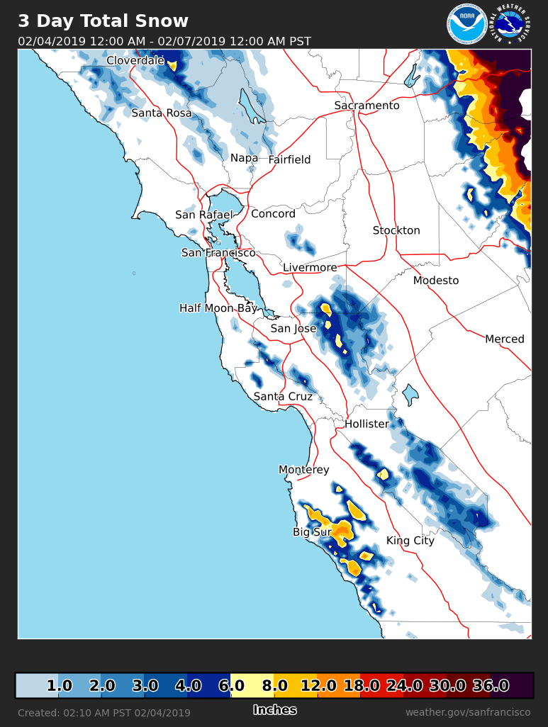
Accumulating snowfall is likely at elevations greater than 1,000ft, but rain mixed with snow is possible all the way down to sea level.
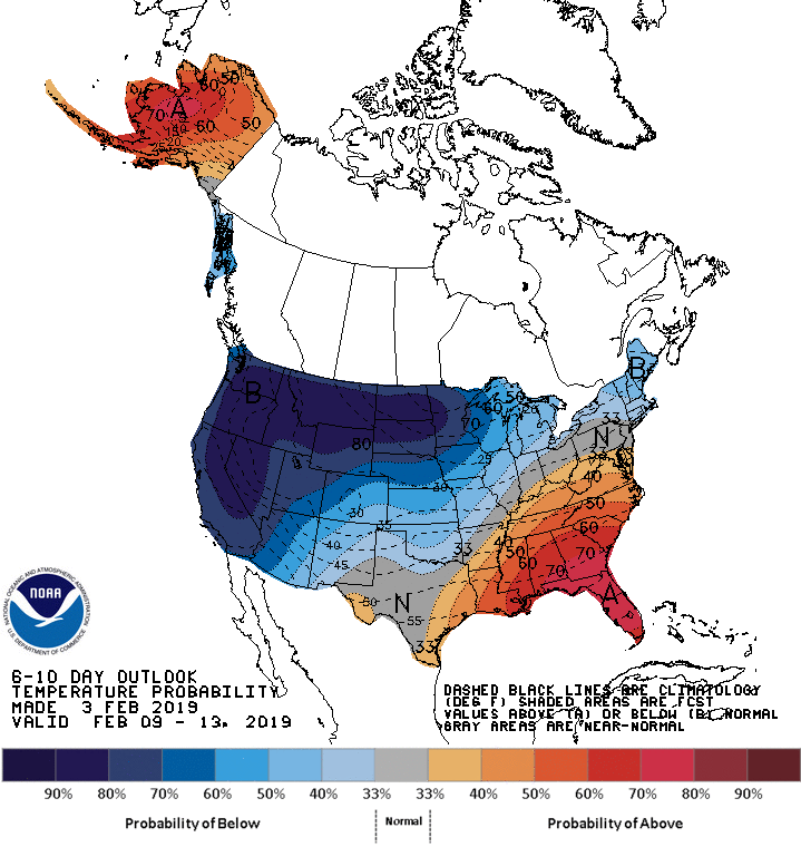
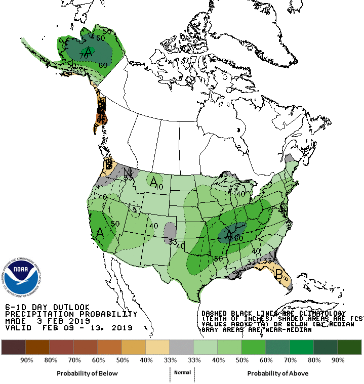
The 6-10 day outlook calls for below average temperatures and above average precipitation in California.
Additional Storm Info:
California: Rain Mixing With Snow All The Way Down To Sea Level
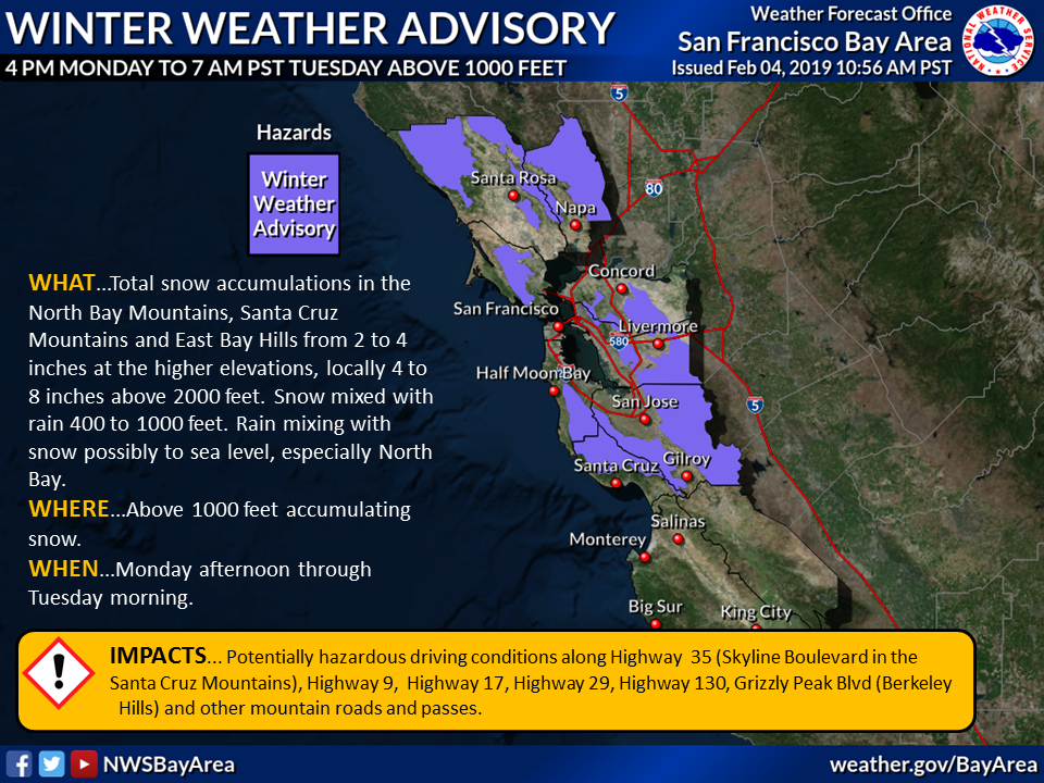
* Total snow accumulations in the North Bay Mountains,
  Santa Cruz Mountains and East Bay Hills from 2 to 4
  inches at the higher elevations, locally 4 to 8 inches
  above 2000 feet. Snow mixed with rain 400 to 1000 feet.
  Rain mixing with snow possibly to sea level, especially
  North Bay.
- NOAA San Francisco, CA
Winter Weather Advisory:
URGENT - WINTER WEATHER MESSAGE
National Weather Service SAN FRANCISCO CA
1048 AM PST Mon Feb 4 2019

...Snow Accumulations and Low Snow Levels through Tuesday...

.A very cold storm system will continue to settle over the Bay
Area Monday afternoon and Monday night further lowering snow
levels. Snow is already falling over the highest peaks Monday
morning, but as snow levels lower snow will begin to accumulate
Monday afternoon and Monday night. Snow levels are anticipated to
be less than 1000 feet for the North Bay, above 1000 feet Santa
Cruz Mountains and East Bay Hills, and above 1500 feet Santa Lucia
Mountains and Southern Gabilan Range. Below 1000 feet, rain will
mix with snow at times and potentially down to sea level,
especially across the North Bay. Precipitation will taper off from
north to south during the day on Tuesday.

North Bay Mountains-East Bay Hills and the Diablo Range-
Santa Cruz Mountains-
INCLUDING THE CITIES OF Angwin, Lagunitas-Forest Knolls,
Woodacre, Blackhawk, Scotts Valley, Boulder Creek, and Day Valley

...WINTER WEATHER ADVISORY IN EFFECT FROM 4 PM THIS AFTERNOON TO
7 AM PST TUESDAY ABOVE 1000 FEET...

* WHAT...Total snow accumulations in the North Bay Mountains,
  Santa Cruz Mountains and East Bay Hills from 2 to 4 inches at
  the higher elevations, locally 4 to 8 inches above 2000 feet.
  Snow mixed with rain 400 to 1000 feet. Rain mixing with snow
  possibly to sea level, especially North Bay.

* WHERE...Above 1000 feet accumulating snow.

* WHEN...Monday afternoon through Tuesday morning.

* IMPACTS...Potentially hazardous driving conditions along Highway
  35 (Skyline Boulevard in the Santa Cruz Mountains), Highway 9,
  Highway 17, Highway 29, Highway 130, Grizzly Peak Blvd (Berkeley
  Hills) and other mountain roads and passes.


GLOBAL WARMING, WE’RE ALL GONNA DIE…
This has never ever happened in the Bay before, ever,
Sorry, my bad.