March 2017 ENSO update: on the fence
With La Niña in the rear-view mirror, forecasters expect that neutral conditions will continue through the spring. After that, there are increasing chances of El Niño making an appearance, but they’re still not very strong chances—around 50% by the late summer, but not quite at the point to warrant an El Niño Watch. What’s behind this verdict?
Pre-trial briefing
First, a quick review of the recent facts. Sea surface temperatures in the Niño3.4 region (our main region for monitoring and predicting ENSO) were close to average during February, measuring -0.15°C below average in the ERSSTv4 dataset, and +0.14°C above average in the OISST dataset. These two datasets have different input and spatial detail, so they’re usually not in perfect agreement, but they are both telling us the same thing: surface temperatures are more or less normal. (Check out Tom’s post for more on how they can disagree and still be reliable.)
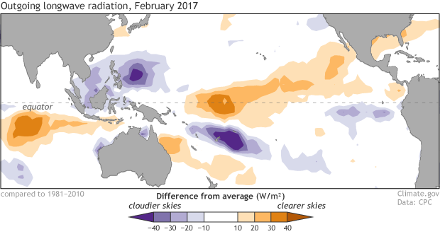
Clouds and rain were still somewhat less than average in February over the central Pacific, and greater than average over the Maritime Continent (the group of islands north of Australia and south of China), in a La Niña-like pattern. Overall, though, both the atmosphere and the ocean are reflecting neutral conditions, with no substantial departures from average.

Witness for the prosecution
ENSO (El Niño Southern Oscillation) forecasters rely on dynamical models—computer models that start from the observed conditions and use physics and mathematics to predict future conditions. To make a forecast for a single target (e.g. a forecast made in March for July’s sea surface temperature), contemporary models are run many times, starting with slightly different observed conditions in each run. Using a range of starting conditions and then running the model forward generates a range of possible outcomes.
The average of all these forecasts is considered the most predictable part of the forecast, but the range itself also provides valuable information. A small range tells forecasters that the models are fairly confident; a wide range means that the models don’t have much agreement on what the future will look like.
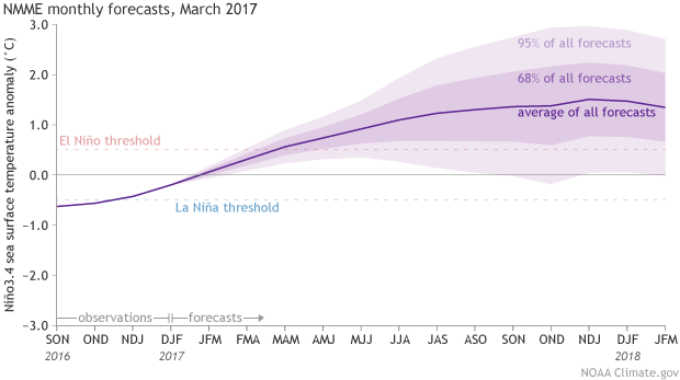
The North American Multi-Model Ensemble (NMME) is a set of several state-of-the-art dynamical models, with over 100 different possible outcomes total. The NMME forecast for Niño3.4-region sea surface temperature is a key contributor to ENSO prediction.

As you can see, the average (the dashed line) is predicting the development of El Niño sometime later this year, and over two-thirds of forecasts are for a Niño3.4 sea surface temperature more than 0.5°C above normal—the El Niño threshold.
Witness for the defense
What the graph also shows, however, is that despite the average being in El Niño territory, a wide range of outcomes are possible—in fact more than what is even shown in the graph (if we had more computing power and more models we could see an even wider range). Getting such spread from models whose starting conditions were only slightly different from one another suggests we shouldn’t be too confident in any outcome yet.
And we can’t forget about the spring predictability barrier—the lower skill of model forecasts made in the early spring. While modern dynamical models have better skill through the spring than older models, we still exercise caution based on our analysis of past model data.
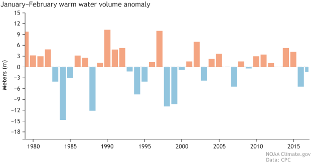
Other than the model forecasts, there isn’t a whole lot of evidence right now that suggests we can more confidently expect El Niño to develop later this year. As Aaron covered in his post last month, one of the factors we look at is the “warm water volume,” the amount of warmer water below the surface of the tropical Pacific. To vastly simplify his point (really, you should check out his great post), more warm water than average during the spring is sometimes, but not always, followed by El Niño. On the other hand, less warm water than average rarely precedes El Niño.
I checked in with our resident oceanographer at CPC, Yan Xue. She reports that although warm water volume has been trending upward over the past several months, the value averaged over January and February 2017 was slightly below average.

Yan also pointed out how warm the rest of the Pacific is, and said that we don’t fully understand how such a warm surrounding ocean could affect the development of El Niño.
As a final rebuttal witness, it’s historically very rare to switch back and forth between El Niño, La Niña, and El Niño three winters in a row. We have only one example in our (admittedly short) record, over the period of 1963-1966. Of course, the prosecution would argue this just proves it’s possible!
Closing statements
If you’re an El Niño zealot, you may have noticed that the Australian Bureau of Meteorology has raised an “El Niño Watch,” meaning they have determined a 50% likelihood that El Niño will develop in 2017. Their system is different from ours—for example, it has three categories of alerts as opposed to our two, and a 50% chance triggers their “Watch” criteria.
We require some more supporting evidence, and so our alert system remains quiet for now. In other words, after careful deliberations, our jury found in favor of the fence.