Forecast Published 11:50 PM MST 2/1/2024
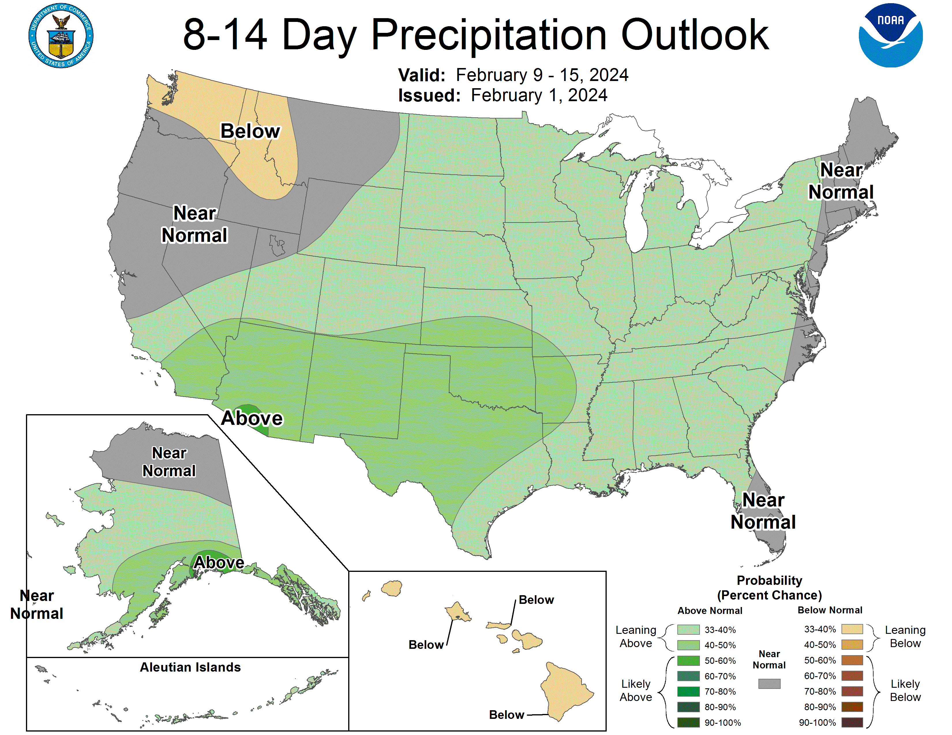
Forecast Summary
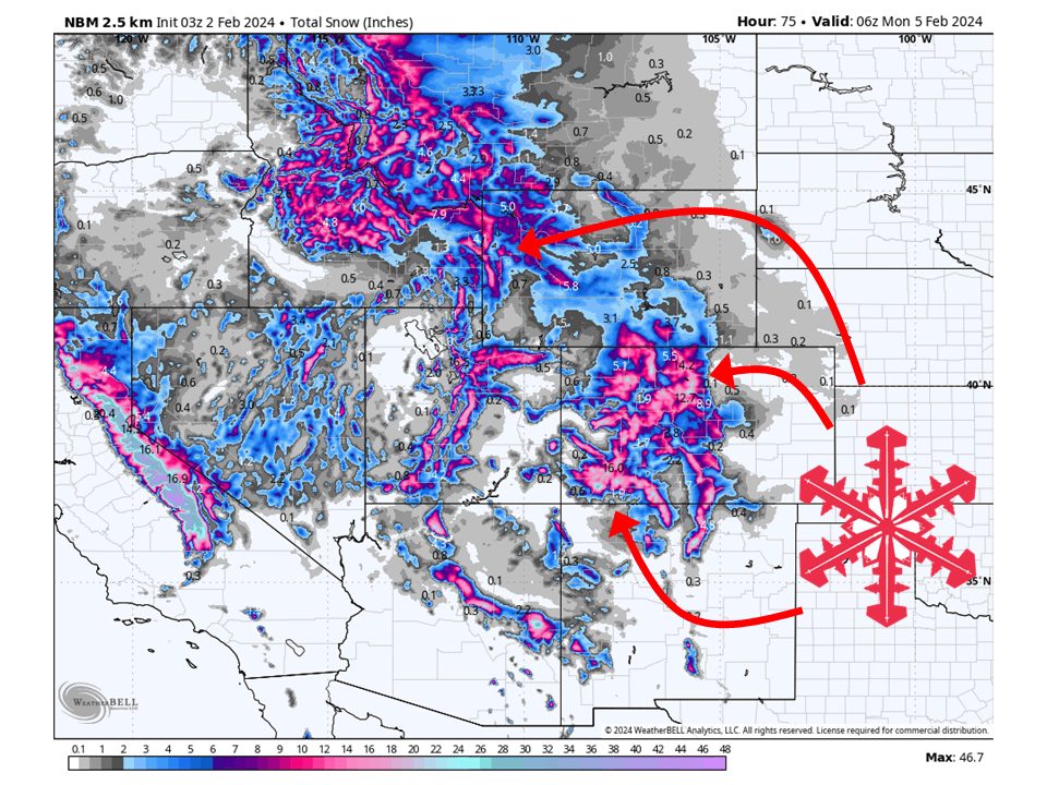
An active pattern is setting up over the Intermountain West and will bring two potent storms to CO/WY over the next seven days. Snow will continue to fill in across Colorado tonight and Friday, bringing widespread mountain snowfall through the weekend. This same storm will push moisture into Wyoming Friday afternoon and bring periods of mountain snow through the weekend as well. More snow is expected through next week.
Short-term
Some scattered snow showers are moving into SW Colorado at the time of this forecast and will continue to fill in as the night goes on. This is all thanks to a substantial moisture tap that is moving into the region from the Pacific, aiming at the San Juans first. This stream of moisture will continue to move eastward through the night and into Friday, bringing widespread mountain snow. By Friday afternoon, snow will also begin to fill in over portions of Wyoming and get going Friday night. Snow will continue across both states through Saturday before it becomes more showery by Sunday. In total, anywhere from 8-24″ of snow is expected across most resorts. However, one thing to keep in mind is this storm will have pretty mild temperatures so snow will be quite dense and heavy.
Notable Resorts Expected Snowfall:
- Telluride: 8-14″
- Silverton: 8-14″
- Steamboat: 14-24″
- Winter Park: 12-18″
- Monarch: 8-14″
- Jackson Hole: 10-14″
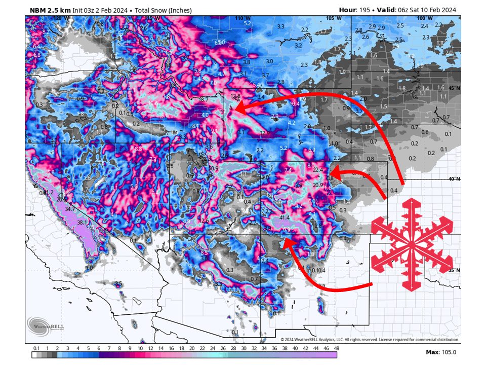
Long-term
The next system will move into the region early Monday, initially bringing snow to portions of western Wyoming. This snow will be aligned with another substantial stream of moisture that will slowly move to the east through Wednesday. This will be in the warmer sector of this storm so snow will be quite dense and heavy to start. However, much colder air will fill in behind this initial band of precipitation. This combined with unstable atmospheric conditions and snow will continue over most mountain locations through the week. By the end of the week, an additional 1-2 feet of snow is likely across most mountain locations in the region, with possibly up to 3 feet in some spots. Exactly where is uncertain, but locations that favor NW flow will see the most.
Extended
A somewhat active pattern looks to continue past next week. Most global ensembles indicate more precipitation is coming to the region, with Colorado and eastern Wyoming having higher chances.