Forecast By SnowBrains Meteorologist – Eric McNamee
11:35 AM MST, Nov. 25, 2020
Forecast Summary:
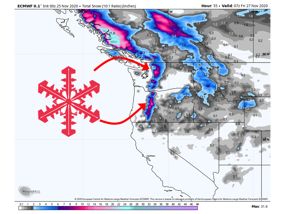
A shortwave trough will bring 8-12″ of snow to the Cascades into Thanksgiving.
Resorts likely to get the most snow are Mount Baker, Crystal Mountain, and Stevens Pass.
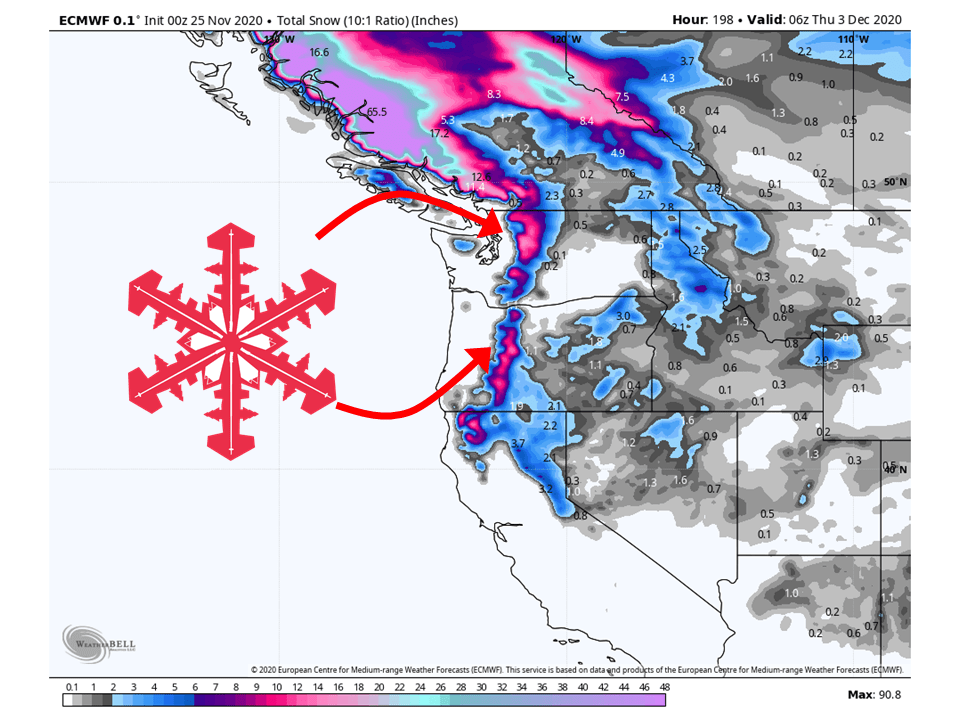
An additional 3-6″ of snow will fall in the northern Cascades on Saturday, then there will be a break in the action early next week.
Short-Term Forecast:
Wednesday-Saturday:
A shortwave trough that is currently over the Pacific Northwest will bring 8-12″ of snow through Thanksgiving.
Cold and unstable northwest flow will keep showers going through the remainder of Wednesday and early Thursday.
Conditions will briefly dry out through the day Friday before another system moves through Friday night into Saturday.
This will drop an additional 3-6″ of snow in the Cascades along the Washington-Canada border.
Today through Friday night...The cold front that
brought an initial stronger shot of precipitation to the area has
since moved inland leaving behind a move convective environment it
it`s wake. While the frontal precipitation and breezy winds have
passed, showers remain bringing periods of more intense rain and snow
showers to the Cascades. Snow levels are dropping as cooler air pools
in behind the cold front. Snow levels have lowered down to around
3500 ft with temperatures at 5000 ft around -3 degrees celsius. With
the lowered snow levels and persisting rain, can expect another
several inches of snow, especially above 5000 ft. As previously
mentioned, there is some lingering convection behind the front which
may produce some isolated weak thunderstorms along the coast line.

Overnight into Thursday, the remaining showers will dissipate as high
pressure over the Pacific builds. This ridge aloft stretches north
across British Columbia, while near the surface it is slightly
flatter. Because of the less amplified surface feature, winds will
generally remain fairly week and offshore. Expecting clearing skies
and dry conditions Thursday through Friday. With the clearing skies
and winds becoming light in the evenings, there is a strong chance
for fog development in many locations below 1000 ft. Fog likely will
become dense at times in more prone areas around the southern
Willamette Valley and backing up to the Coast Range foothills.
-NWS Portland 11/25/2020
Long-Term Forecast:
Sunday-Tuesday:
Conditions will clear out Sunday and Monday before another system affects the southern Cascades.
Snowfall amounts are not certain at this time but some snow is expected.
Conditions look to clear out heading into the extended forecast.
Extended Forecast:
Tuesday and Beyond:
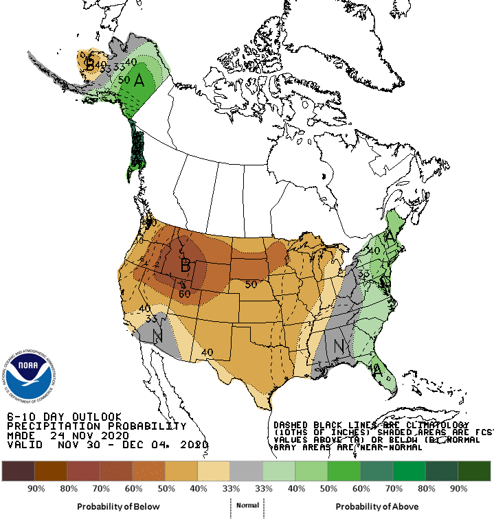
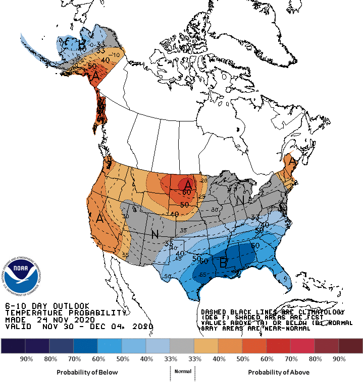
As mentioned above, conditions will clear out in the extended as high pressure builds over the Pacific Northwest.
This will bring above-average temperatures and below-average precipitation to the region 6-10 days out.