A sizable early-season storm will dig into the Pacific Northwest this week, bringing feet of snowfall to local resorts between Thursday and Sunday. After Sunday, a warm and wet system will move in, bringing high-elevation rain early next week. Best to get out before the rain ruins the goods of this weekend!
The first snowfall will creep into Oregon on Thursday morning. Between Thursday and Thursday night, central and southern Oregon should score 4-12″, with 6-9″ being the most likely range at mid-mountain at Bachelor and Hood. Washington resorts should pick up a few inches, with the deepest totals in the south of the state. Strong snowfall will continue during the day on Friday, including precipitation spreading north and intensifying into Washington. Friday will bring 3-7″ during the day for Washington resorts (highest totals at Crystal and Snoqualmie Pass) and 6-12″ at Mt. Bachelor and Mt. Hood, with Bachelor likely picking up the most snow.
Snowfall will really pick up on Friday night and drop 7-15″ across the region overnight. The precipitation bullseye on Friday night looks to be centered on southern Washington and northern Oregon, so Crystal and Mt. Hood are both looking excellent for Saturday, especially with an additional 3-6″ expected for resorts around the region during the day on Saturday. Bachelor will be the exception; as the precipitation moves south, Bachelor will pick up another 8-14″ during the day on Saturday, adding to an already extremely impressive storm total. Considering the deep overnight totals from Friday night and the additional snow on Saturday, Saturday will be the best day for skiing in the foreseeable future.
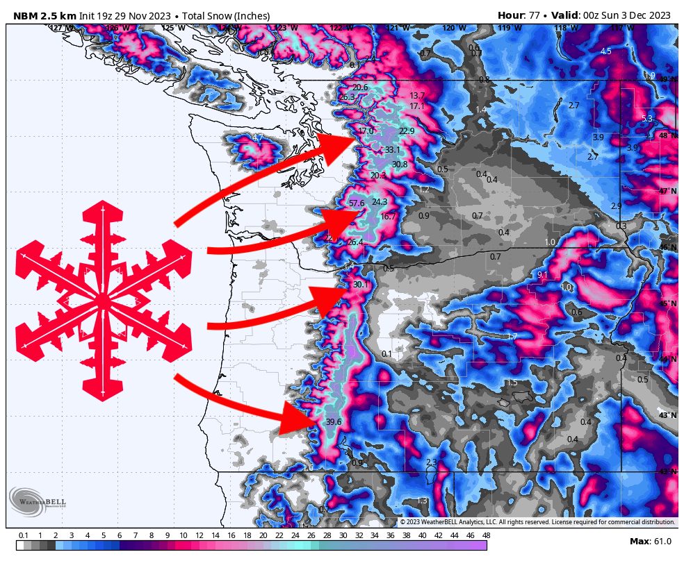
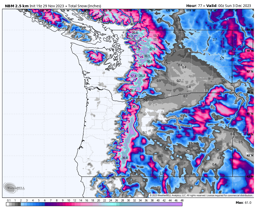
By Saturday evening, here are what I see as realistic totals at resorts around the region:
- Mt. Baker – 15-25″
- Alpental – 18-28″ (with decent odds to exceed this range)
- Crystal – 20-28″
- Mt. Hood – 28-36″
- Mt. Bachelor – 30-40″
Below is a multi-model blend depicting snowfall totals by Saturday evening:
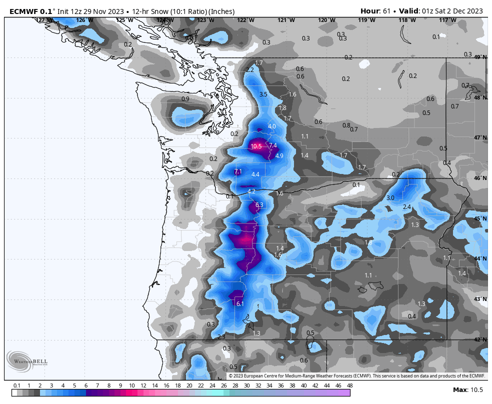
On Saturday evening and night, precipitation will ramp back up as a warm tongue of moisture arrives from the Pacific. Unfortunately, due to the tropical origin of this moisture, the precipitation will be warm and likely fall as rain. Rainfall rates will peak early Sunday afternoon, with 6,500-7,000-foot snow levels in southern Oregon and 4,500-5,000-foot snow levels in Washington and southern BC (with a gradient in between). In other words, there will be a significant rain event that will bring liquid precipitation to all resort base areas and above most mid-mountains (and for some resorts, above the summits). This system should dissipate on Monday morning/afternoon.
Unfortunately, many models are indicating another warm and wet system could move in on Tuesday, although this looks like it will be smaller than Sunday’s rain event if it does end up materializing. Odds increase for cold temperatures and snowfall again late next week.