
Summary
A quick-hitting storm will roll through the Pacific Northwest between Thursday afternoon and Friday evening this week, bringing good snow accumulations to central & southern Washington and northern Oregon. Elevations above 3,500-4,500 feet in central and southern Washington and above 4,500-5,500′ in Oregon should see mostly snow during the storm. Above these elevations, accumulations will be between 4-8″ with up to 30″ on Mt. Rainier and Mt. Hood.
Thursday afternoon and evening

The first precipitation will come from almost due West into Northern Washington on Thursday morning. This initial wave of precipitation will not be significant. The highest totals will be near the summit of Mt. Baker, where 6-8″ are possible up above 10,000 feet. The top of Mt. Baker Ski Area should see about 4″. The rain-snow line will be around 3,500 feet in the Northern Cascades during this first burst of precipitation, so even some of the valleys could see a few inches.
The precipitation will move into Washington and Oregon from the west-southwest, reaching the coast by 1-2 pm. The wave of precipitation will be just barely creeping into the mountains by sunset on Thursday.
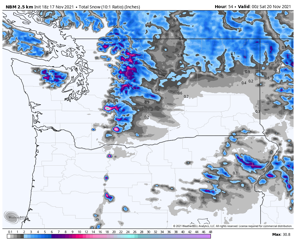
Thursday night-Friday
Things will really start to ramp up after 6-7 pm on Thursday as the moisture makes its way into the mountains of Washington and Oregon. The American model has the first push of snow a bit more intense than I think it will be, but snowfall rates will max out at about a half-inch per hour overnight in southern Washington and Oregon. Snow levels will drop down to as low as 3,000 feet during this period.
There will be a lull in the precipitation around midnight, but the second, stronger wave of precipitation will move through shortly after between 4 and 9 am or so. I don’t have very good confidence in the specifics of when exactly this wave will roll through, but I am confident that it will strongly favor southern Washington and northern Oregon. Very little snow will make it north of Steven’s Pass. The European model has this second round of precipitation exiting to the East sooner in the morning, while the American and Canadian models have things sticking around until the afternoon. I see things exiting out of southern Washington by 10 am-noon with precip lingering in Northern Oregon until later on Friday afternoon/evening.
This storm is being driven from the top-down, meaning elevation will play a smaller role than it usually does. The precipitation is being generated in the upper levels of the atmosphere, so totals will be more widespread and less strongly favored in the mountains. There will still be some orographic bonus for upper elevation peaks like Rainier and Hood, but much less than is typical at this time of year.
Rainier and Hood are much higher than the rest of the surrounding terrain, so temperatures alone will provide a huge boost for snowfall. Snow to liquid ratios on Rainier will be between 18 and 20:1 (20 inches of snow for every inch of water) and 15:1 or so on Hood, compared to 10 or 12:1 on even the highest surrounding peaks. This will allow snowfall on the summit of Rainier to realistically climb up to about 30-35″. Hood, Adams, and Jefferson should all see between 20 and 25″ by Saturday morning. As mentioned in the summary, elevations above 4,000 feet or so should see between 4″ and 8″ of snow by Saturday. I think this is a somewhat conservative forecast, as peaks above 6,000 feet could certainly go for 10″ or more. However, with hit-or-miss storms like this one, it’s better to go with a safe forecast. I have high confidence in the 4-8″ forecast.