This forecast was created at 1:30 p.m. PST on Friday, March 28, 2025.
A series of spring storms will continue to deliver fresh snow across Colorado over the next several days, with periods of moderate to locally heavy snowfall favoring the northern and central mountains. Lingering snow through Sunday morning will give way to a brief lull before another round of light to moderate accumulations early next week. By midweek, additional snow will spread across much of the high country with generally cooler temperatures supporting decent snow quality, especially above 8,000 feet.
Snow will overspread much of the Colorado high country late Friday into Saturday morning. Showers developing Friday afternoon will become more widespread Friday evening, initially above 9,000 to 9,500 feet before lowering to around 7,500 to 8,000 feet by Saturday morning. Areas like the Park Range and central mountains should see moderate accumulations in the higher elevations, while peaks along the Continental Divide and Front Range mountains will pick up a few inches. Snowfall rates Friday night into early Saturday should generally support moderate snow-to-liquid ratios in the 9–13:1 range, meaning fair quality snow but not especially deep fluff. By Saturday afternoon, coverage will decrease briefly before the next system arrives.
A second wave Saturday evening through Sunday will reinforce snow showers in the northern and central mountains. Snow levels will dip lower, anywhere from 5,000 to 7,000 feet, favoring colder conditions and a light to moderate round of fresh snow. In the southern mountains, additional accumulations are expected north of Cottonwood Pass and near Wolf Creek, though most spots will see lighter amounts than during the Friday-Saturday period. Snow ratios overnight Saturday into Sunday could approach or exceed 14:1 at times, yielding lighter, fluffier snow in favored spots. By Sunday afternoon, snowfall coverage begins to wane, but light showers may linger across high terrain through Sunday night.
A brief lull in activity is anticipated Monday into Monday night, but another disturbance is set to arrive by Tuesday. This system should bring more widespread mountain snow, with many resorts picking up moderate totals Tuesday into Wednesday. Snow ratios are likely to be quite high (often above 14:1), so while precipitation amounts may be moderate, the resulting snowfall should be fairly fluffy and enjoyable. Some gusty winds are possible along the higher ridges by Tuesday afternoon, which could impact the ski experience for a time. Beyond midweek, unsettled conditions may persist into late next week, although confidence in exact timing and amounts decreases. Longer-term outlooks suggest below or near normal temperatures continuing over western Colorado, helping to preserve the snowpack a bit deeper into spring.
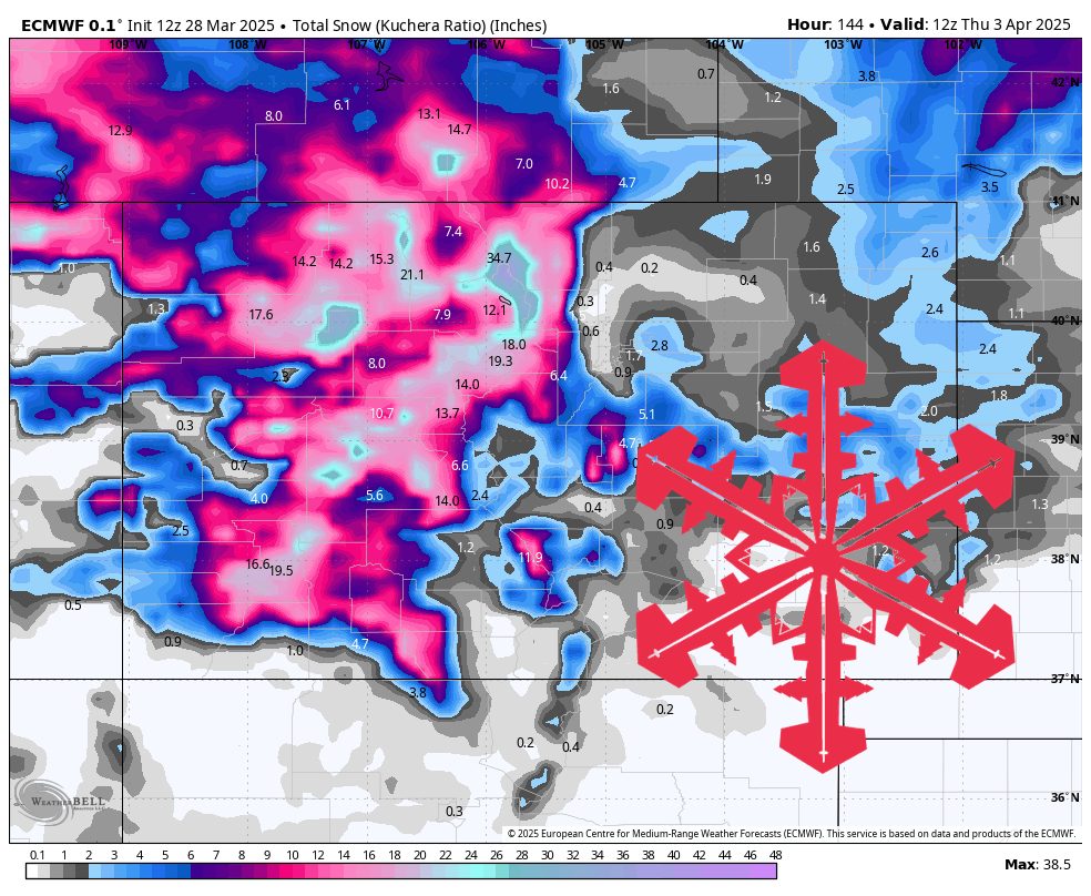
6-day Resort Forecast Totals
- Steamboat – 11″-20″ Fri night (03/28) – Thu (04/03)
- Snowmass – 9″-18″ total (2″-4″ Fri night (03/28) – Mon night (03/31) + 7″-14″ Mon night (03/31) – Thu (04/03))
- Winter Park – 9″-16″ total (4″-6″ Fri night (03/28) – Mon (03/31) + 5″-10″ Mon night (03/31) – Thu (04/03))
- Wolf Creek – 7″-16″ total (2″-4″ Fri night (03/28) – Sat night (03/29) + 5″-12″ Mon night (03/31) – Thu (04/03))
- Loveland/Arapahoe Basin – 7″-16″ total (2″-5″ Fri night (03/28) – Sun night (03/30) + 5″-11″ Mon night (03/31) – Thu (04/03))
- Crested Butte – 7″-15″ total (2″-3″ Fri night (03/28) – Sun night (03/30) + 5″-12″ Mon night (03/31) – Thu (04/03))
- Vail/Beaver Creek – 7″-14″ total (2″-3″ Fri night (03/28) – Sun night (03/30) + 5″-11″ Mon night (03/31) – Thu (04/03))
- Telluride – 6″-13″ total (1″-3″ Fri night (03/28) – Sat night (03/29) + 5″-10″ Mon night (03/31) – Thu (04/03))
- Monarch – 5″-11″ total (2″-3″ Fri night (03/28) – Sun (03/30) + 3″-8″ Mon night (03/31) – Thu (04/03))
- Copper Mountain/Breckenridge – 4″-9″ total (1″-2″ Fri night (03/28) – Sun night (03/30) + 3″-7″ Mon night (03/31) – Thu (04/03))