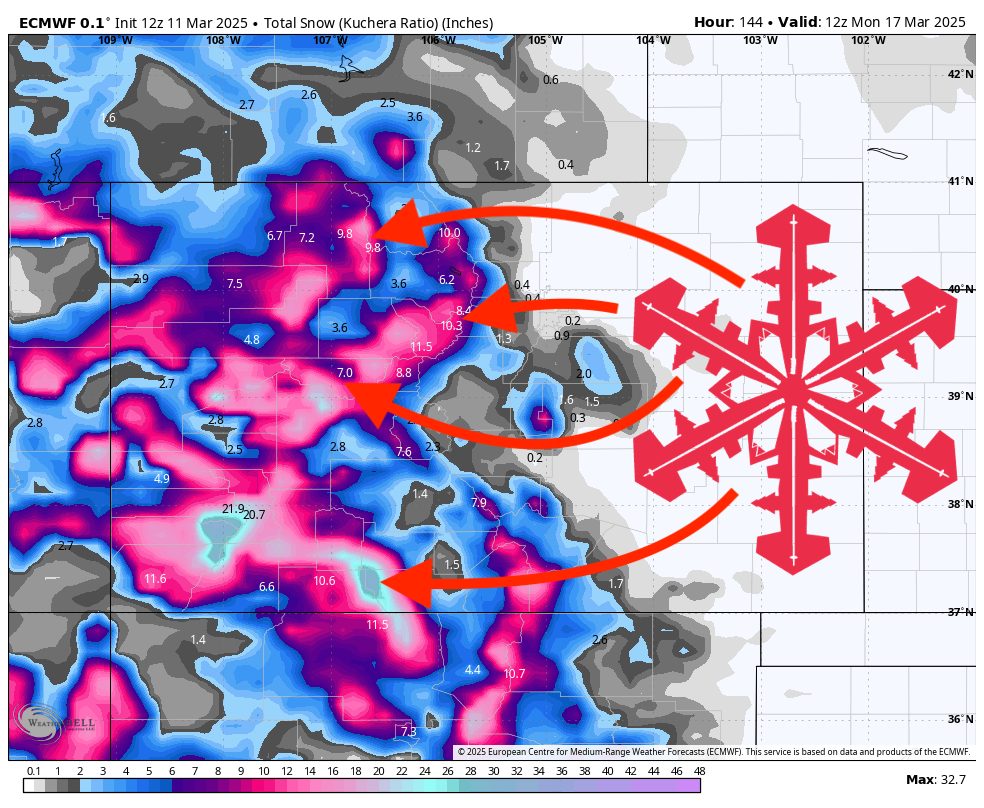
A potent winter storm will sweep through Colorado this Thursday and Friday, delivering widespread accumulations and windy conditions before tapering off with a smaller wave Saturday and a brief break on Sunday, then another system arrives early next week. Overall, colder air and high snow-to-liquid ratios should ensure decent snow quality for higher elevations, with most resorts picking up moderate to occasionally heavy totals from late this week into the weekend.
Wednesday will start on a quiet note. Dry conditions prevail across the Colorado mountains with mild temperatures, offering a relatively calm day on the slopes. Late Wednesday, there’s a small possibility of spotty light snow in the far southern mountains, but any accumulation will be negligible for most ski areas.
Thursday–Friday brings the main winter storm. Snow will begin on Thursday morning in the higher terrain of western Colorado, quickly intensifying by afternoon. Snow levels will initially hover around 7,000 feet for western ranges, dropping near 5,000 feet after the frontal passage, while central/southern areas see levels around 5,500 feet. This storm is accompanied by strong winds, especially on exposed ridgelines. Accumulations of 6 to 12 inches or more are expected in the western ranges, and moderate to heavy snow is likely in central and southern mountains by Thursday night into Friday. With SLRs commonly in the mid to upper teens, snow quality should be light and reasonably fluffy, although gusty ridgetop winds may transport snow and could create variable surface conditions.
Saturday keeps conditions unsettled. As the main storm weakens, an additional wave of snow will slide through, dropping another 1 to 4 inches in many higher-elevation areas. Temperatures remain below seasonal averages, preserving good snow quality on the slopes. By late Saturday, snowfall will diminish from west to east, with Sunday likely turning drier and slightly warmer as a transient ridge of high pressure moves overhead.
Early next week, attention turns to the next approaching system. Monday looks breezy and milder, with warming temperatures driven by downsloping winds. Light snow showers could develop by Monday night or Tuesday as another disturbance arrives. Looking longer range, western areas (including Colorado) stand a good chance of continued unsettled weather and colder-than-normal temperatures through the extended outlook, suggesting more potential snowfall events beyond early next week.
Resort Forecast Totals
- Wolf Creek – 10”–17” Thu night (03/13) – Sun (03/16)
- Telluride – 9”–17” Thu night (03/13) – Sun night (03/16)
- Steamboat – 7”–13” Thu night (03/13) – Sun night (03/16)
- Vail/Beaver Creek – 6”–13” Thu night (03/13) – Sun night (03/16)
- Snowmass – 6”–12” Thu night (03/13) – Sun night (03/16)
- Crested Butte – 5”–9” Thu night (03/13) – Sun night (03/16)
- Loveland/Arapahoe Basin – 4”–8” Thu night (03/13) – Sun night (03/16)
- Winter Park – 4”–8” Thu night (03/13) – Sun night (03/16)
- Copper Mountain/Breckenridge – 3”–6” Thu night (03/13) – Sun night (03/16)
- Monarch – 3”–6” Thu night (03/13) – Sun night (03/16)