Forecast by SnowBrains Meteorologist Rowan Sullivan
1:30 a.m. MST October 25
Forecast Summary
A powerful atmospheric river is slamming California with huge rainfall totals and the Sierra Nevada with big snow. As the system progresses inland, Utah and Wyoming resorts are next in line for active weather.
Precipitation will begin Monday ahead of a strong cold front. Snow levels will be quite high (10,000’+) prior to frontal passage, dropping quickly by Monday night as cooler air filters in.
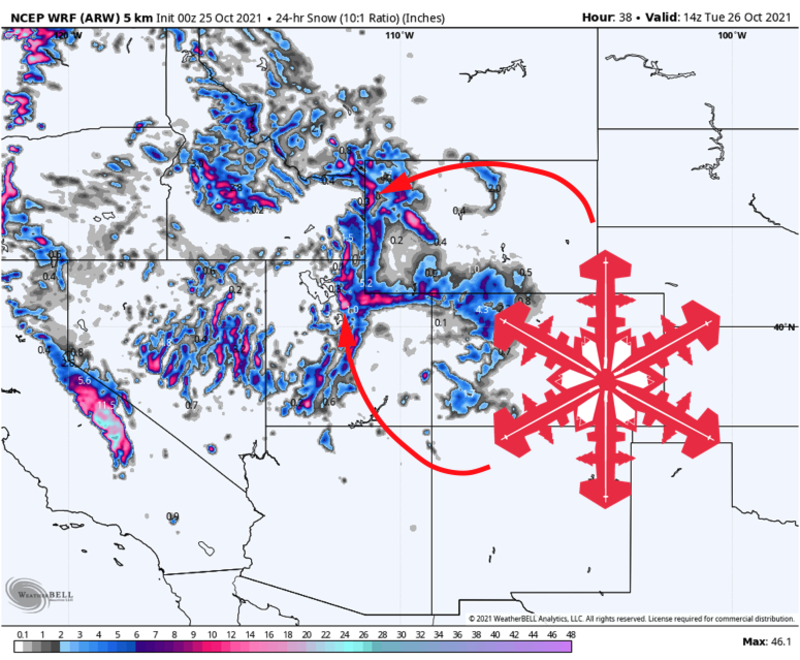
Wyoming resorts including Jackson Hole and Grand Targhee can expect 5-10″ of dense snow by midday Tuesday.
Utah resorts will do comparatively better, with 8-15″ of snow by Tuesday evening.
Short Term Forecast
Monday – Tuesday
Monday will start off warm across Utah and Wyoming. Southwesterly flow will introduce warm air to the region, lifting snow levels as high as 10,000′ by Monday afternoon. Wyoming resorts will see rain showers through the day Monday, with a bit of snow mixing in at the highest elevations.
A strong cold front will push through most Utah and Wyoming resorts by Monday evening. The front will be accompanied by a quick drop in temperatures and a burst of very heavy snow, with snow levels dropping to 6,500′ overnight.
Snow will taper off across western Wyoming on Tuesday morning, after 5-10 inches of snowfall. Snowfall totals will be very elevation-dependent, with Jackson’s peak picking up much more snow than its base.
Utah resorts from Sundance northward will see heavy snow overnight Monday. Unstable and moisture-rich northwesterly flow behind the cold front will keep the chance for snow showers around into Tuesday afternoon.
In Utah, the Cottonwood Canyon resorts will pick up the most snow. Alta and Snowbird will benefit the most from the postfrontal northwesterly flow, so expect 10-15″ in Little Cottonwood and 8-14” in Big Cottonwood Canyon by Tuesday evening. Park City resorts are in for 4-8″ of snow, with the northern Utah mountains looking at 5-10″ totals.
Wednesday
A second disturbance will brush Wyoming Wednesday morning. This will make for a burst of snow showers over Grand Targhee and JHMR, adding an extra 2-4″ of snow through Wednesday. It all helps!
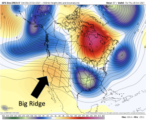
Long Range Forecast
By the middle of next week, an upper-level ridge will build across the American West, shutting down chances for more storms for a while.
Things look to stay quiet as we head into the first week of November, with ridging remaining the dominant weather feature over the west. This should give us some time to appreciate one of the snowier Octobers in recent memory!