As temperatures increase, average snowfall frequency is estimated to decline across the Pacific Northwest by the turn of the century, and potentially at an even faster rate if greenhouse emissions are not reduced, according to a new Portland State University study.
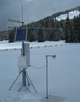
PSU researchers plotted the projected change in the number of snow days against rain days at 157 SNOTEL stations in Oregon, Washington, and Idaho. SNOTEL, or snowpack telemetry network, sites are often used to monitor water availability in mountainous regions and provide an observational baseline for defining snowfall. Using climate model projections, changes in the ratio of snow days to rain days are estimated relative to observations at these stations, explains Science Blog.
Calculating changes at these locations across the mountainous Northwest can provide information at scales relevant to those monitoring and managing water resources.
“These snow-dominated regions are going to start to see an increasing proportion of precipitation falling as rain,” author and postdoctoral scholar Arielle Catalano said. “This gives us a sense of the site-specific changes in time and space, what’s going on in this region, and what we can expect to see on average in terms of snow versus rain days over time.”

Highlights of the study’s findings, published in the journal Geophysical Research Letters:
- By the end of the 21st century, over 90% of SNOTEL stations across the Northwest will continue to receive snow, but many of these locations will experience more than half of wet days as rain, meaning more precipitation will fall as rain instead of snow.
- Snowfall frequency declines are largest at low- and mid-elevation sites like the Cascades
Catalano added global efforts to mitigate greenhouse gas emissions can slow the rate of decline. At virtually all of the stations, business-as-usual emissions would lead to a faster rate of decline throughout the second half of the 21st century, whereas mitigating emissions results in slowing rates.