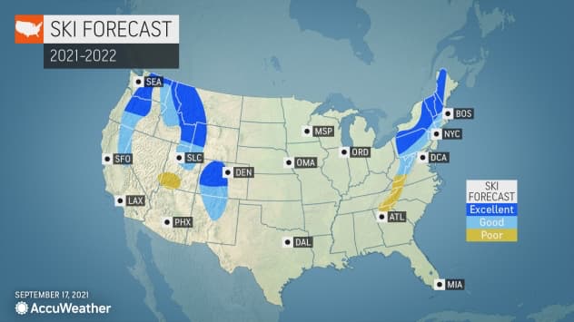
September is now behind us and we’re into October which typically sees the first ski resorts in North America start turning their lifts. Which means that winter is just around the corner.
If you’re not overwhelmed yet by winter forecasts (NOAA, Old Farmer’s Almanac, Farmer’s Almanac, Direct Weather), AccuWeather’s meteorologists have just released their winter forecast. Highlights are below, but check out their website for the detailed forecast.
AccuWeather is predicting some similarities this year compared to last winter due to La Niña. Last winter, La Niña was a driving force that shaped the weather patterns across the country throughout the season and is once again predicted to shape part of the overall weather patterns this winter. However, the upcoming La Niña will be weaker than the one experienced last winter. This “opens up the door” for other elements to factor into the winter forecast, especially during the second half of the season.
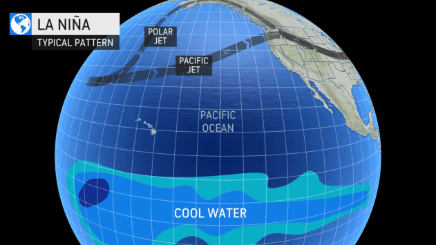
There are also indications entering this winter season that, unlike last year, the polar vortex can be weaker. This could allow colder air from the Arctic to slide southward into the U.S. before the official start of meteorological winter, which is on Dec. 1. Astronomical winter, the first official day of winter, arrives on Tuesday, Dec. 21.
Take a look at the complete region-by-region breakdown of the U.S. winter forecast below:
Northeast
Residents across the northeastern U.S. might want to dig out their winter coats sooner rather than later as winter weather could make an early arrival across the region this year.
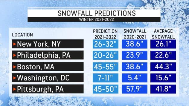
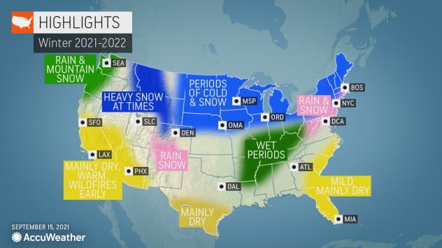
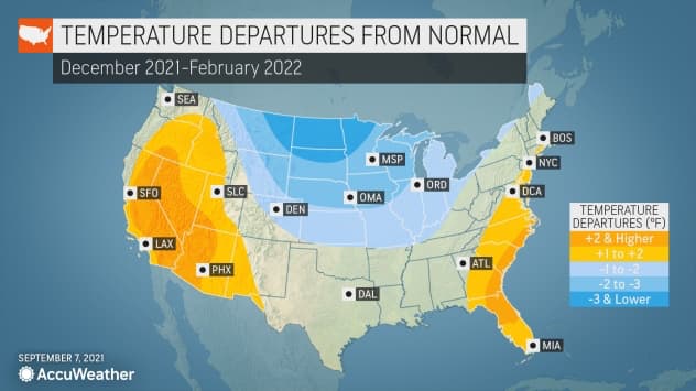
“This year, I think, is going to be a colder one, at least for the interior sections from the Appalachians to the Ohio Valley and Great Lakes,” says AccuWeather. Last winter, temperatures across these areas were right around normal, but this year, the winter as a whole is likely to average 1 to 3 degrees Fahrenheit below normal.
The first waves of cold air are anticipated to chill the Northeast in November when there could be “a couple of rounds of cold weather and some snow,” particularly across the interior Northeast. The chance of plowable snow is also anticipated to start early in the season with the early waves of cold air.
Areas closer to the coast, such as Boston, New York City, and the rest of the Interstate-95 corridor, could also get the chance of early-season cold and snow, but it is not predicted to be as cold or as snowy as across areas farther inland.
The severity and frequency of the snow and cold air are likely to let up a bit by mid-December before returning with a vengeance in January.
Sometimes during January, there is a period during which the cold air lets up, referred to by some meteorologists as a “January thaw.” But this coming winter, that respite from the frigid weather could occur a few weeks later, making it more of a “February thaw.”
Great Lakes & Northern Plains
Similar to the Northeast, folks across the Great Lakes and the north-central U.S. should brace for a colder-than-normal winter with snowy spells throughout most of the season.
Winter will start off strong with snowstorms tracking from the foothills of the Rockies through the Great Lakes, providing early-season snow for many of the favorite snow-related activities, such as skiing, snowmobiling, or winter-themed festivals.
Farther west, the bigger story will be the unrelenting waves of cold air. Temperatures in January could end up being 5 to 10 degrees Fahrenheit lower than they were last winter across the Plains — and the Arctic air is likely to remain in place over the region into February.
Pacific Northwest & Northern Rockies
La Niña winters typically translates to a stormy season for the Pacific Northwest, and while La Niña is in the offing this winter, it may not trigger as much stormy weather as in years past.
A wet winter is still anticipated with plenty of snow in the mountains, but it might not total as much as last winter, and more breaks in the stormy pattern are projected. Still, there will be enough precipitation to lay down a healthy snowpack for ski resorts across the Pacific Northwest and the northern Rocky Mountains.
Snow from these storms could blanket Denver, but the city is not likely to have a repeat of last winter, which was the snowiest in 37 years with more than 80 inches of snow accumulating throughout the season. Snowfall this season in Denver should be closer to normal, which is 56.5 inches.
Southwest
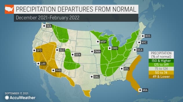
As waves of storms start to soak the Pacific Northwest periodically through autumn and into the first part of winter, people who live across areas farther south may be wondering when meaningful rain will reach California and the rest of the Southwest.
The lack of early-season precipitation will allow the ongoing wildfire season to extend all the way into December, an unusually late end to the season. More fires will be possible across the Sierra and elsewhere in California before the arrival of the wet season.
As the calendar turns from December to January, the prospects for rain will increase for California. Typically during La Niña, storms from the Pacific Ocean generally track toward Washington and Oregon, leaving California high and dry, but a different story may unfold later this winter.
“This is not a typical La Niña,” AccuWeather says, adding that as La Niña weakens later in the season, it will allow other factors to influence the storm track.
This will open the door for meaningful precipitation across California during the second half of the winter, but it is “not going to be a drought buster.”
The lack of persistent storms will lead to most of California and the rest of the Southwest being milder than normal this winter, although a few cold spells can’t be ruled out, particularly across the interior Southwest.
There are some chances for storms to dive down from the Northwest across the Four Corners, bringing the chance of precipitation to the interior Southwest.
This will be beneficial for ski resorts across Utah, Colorado, New Mexico, and Arizona, although these interior storms may not take place until later in December and into January.
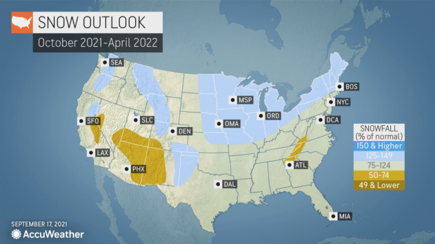
The “Snow Outlook” graphic shows an interesting gradient of predicted snow around the Tahoe Basin. The problem is that the label for San Francisco Airport covers all of the ski areas in the Tahoe area making it hard to decipher whether the predicted percentage of normal snow at your favorite resort is 75-124% or 50-74%. The Tahoe area is is also very close to the 125-149% predicted area adding to the gradient. (The SLC and Seattle area resorts are covered as well, but those areas are not near boundaries.)
From all of the predictions listed in paragraph 2 above, it looks like the Tahoe area prediction is it going to be one of those years where a storm track difference of 50 miles will make or break the season. Most likely, it will be a 3-major-storm season: a Thanksgiving dump to set the base; a Christmas-to-New Years blizzard to keep it white, and a President’s Day puking to prep for spring skiing. There will still be some minor storms of 1 – 3 feet to help with the coverage between the major storms, but also the 4-5 weeks of spring skiing in January and February that we all love. In other words, a normal season.