The National Weather Service has issued a Winter Storm Watch and Winter Weather Advisory for parts of western Montana. A cold front is moving through, which will turn precipitation from rain to snow.
Southwestern Montana is expected to see 8-18″ of New Snow Today – Friday.
NOAA Has Issued A Winter Storm Watch For:
Montana
NOAA Has Issued A Winter Weather Advisory For:
Montana
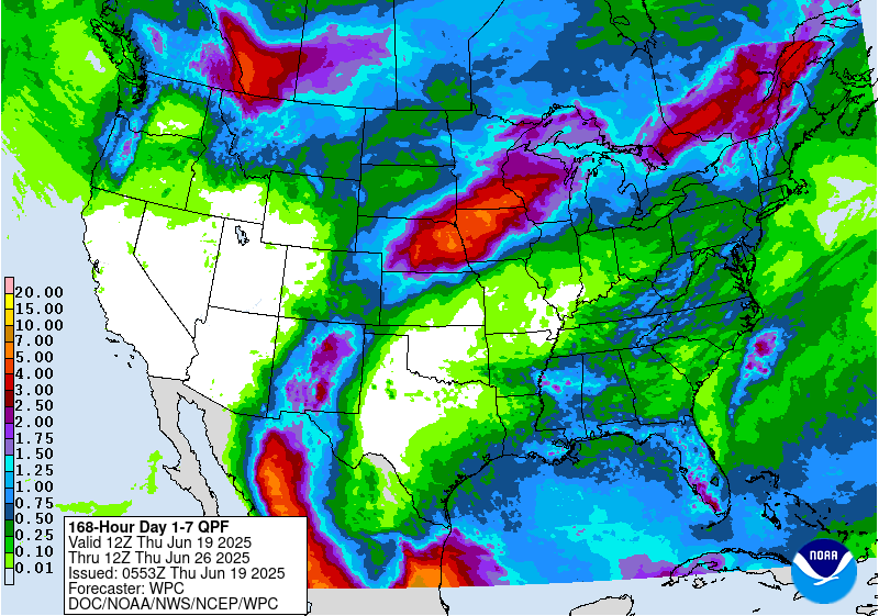
7 day GEM Model shows snow for the West. Image: Tropical Tidbits7 day precipitation totals. Image: NOAA
The highest snow accumulations will be above 8,000ft, but snow levels are expected to drop below 6,000ft.
Additional Storm Info:
Frost is in the forecast Friday – Sunday. Image: NOAA Great Falls, MTSnow is on the way throughout the next few days in Montana. Image: NOAA Billings, MT
Montana: 8-18″ of Snow Above 8,000 Feet Tonight – Friday
Southwestern Montana Forecast. Image: NOAAThe wet and cool forecast for southeast Montana is still on track for later this week. Snow can be expected in the high country, while rain can be expected across the plains. Image: NOAA Billings, MT
Montana Winter Storm Watch:
URGENT - WINTER WEATHER MESSAGE
National Weather Service Billings MT
351 AM MDT Wed Sep 20 2017
...WINTER STORM WATCH IN EFFECT FROM THIS EVENING THROUGH LATEFRIDAY NIGHT...
The National Weather Service in Billings has issued a Winter
Storm Watch...which is in effect from this evening through late
Friday night.
* IMPACTS...Travel in the high country will be affected by periods
of accumulating snowfall. Hunters and recreationists should be
prepared for wintry conditions.* TIMING...Tonight through Friday night.
* SNOW ACCUMULATION...8 to 18 inchespossible, greatest above 8000 feet.
6-10 day temperature outlook. Image: NOAA6-10 day precipitation outlook. Image: NOAA