
It’s that time of year again when skiers, and snowboarders start getting anxious wondering when it’s going to start snowing. What kind of year are we going to end up having? The beginning of the season is always exciting.
There are three teleconnections that are going to be the driving mechanisms to Lake Tahoe’s winter.
#1. The Pacific Decadal Oscillation (PDO)
#2. Quasi-Biennial Oscillation (QBO)
#3. The development of a weak/moderate El Nino.
We have been in a cold PDO since approximately 2005/2006. It is called the Pacific Decadal Oscillation, because it is a long lived El Nino like pattern poleward of 20 degrees. Even with the limited understanding of how they occur they can be predicted 10 years in advance with the periodicity varying from 15-25 years.
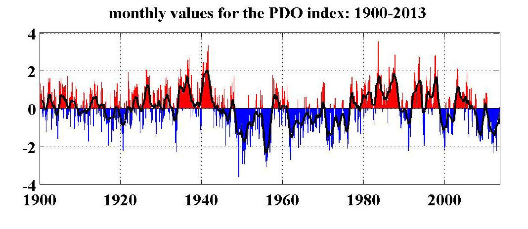
Short anomalies can exist with the last one occurring in 2010/2011. This coincides with the monster year that we had as you can see on the chart above. Coincidence , or is there no such thing?
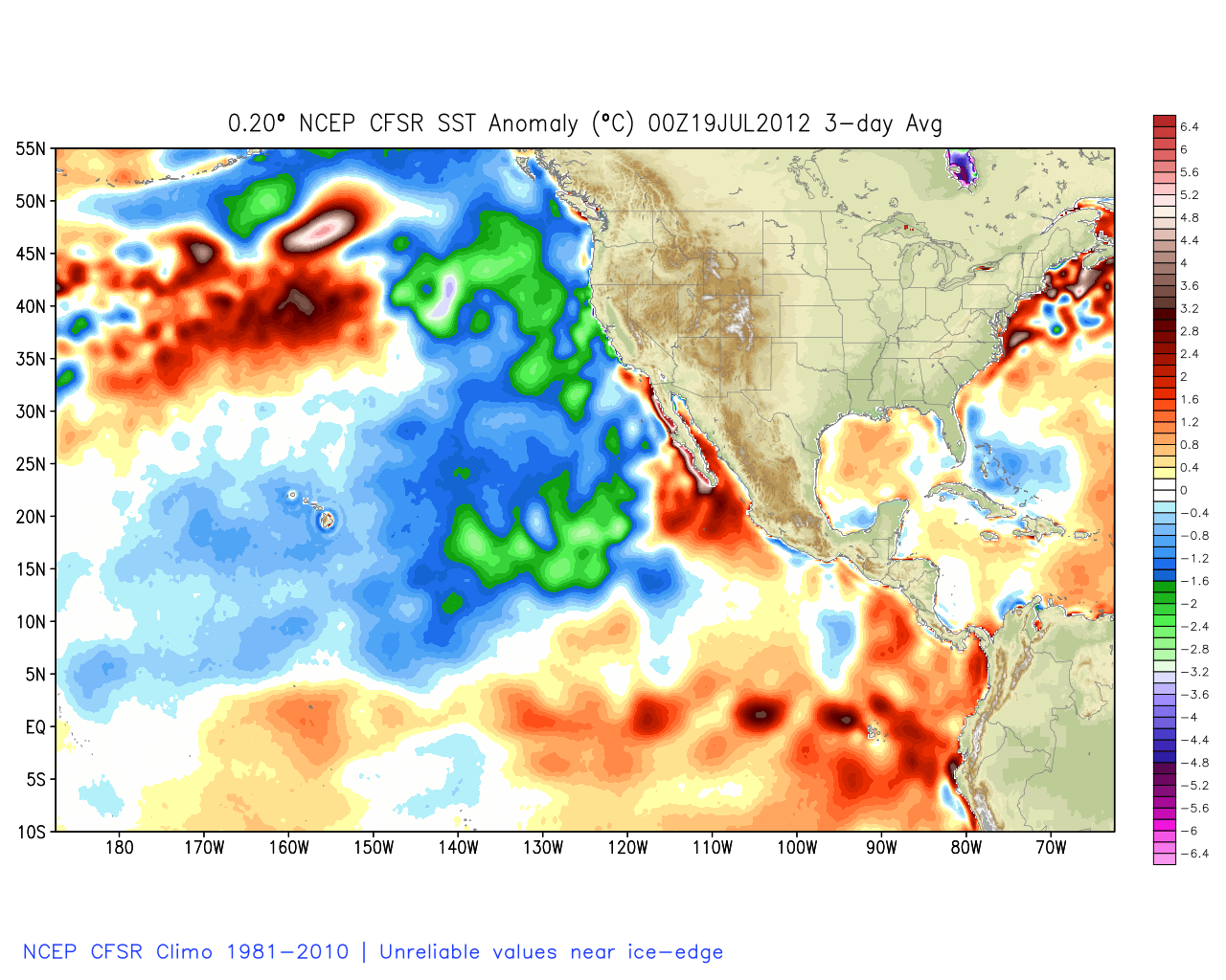
Here is a look at the cold or -PDO back in July 2012.
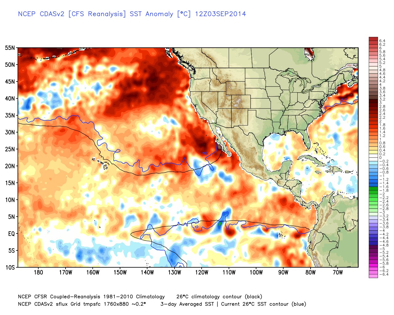
Here is a look at the most current image from September of the +PDO. Notice the intense warm pool off the coast of Baja, more on that later.
In order to avoid turning this into a meteorology lesson the Quasi-Biennial Oscillation is looked at simply as a function of latitude and pressure. When the QBO is in its eastern phase or -QBO, it supports more blocking in the upper latitudes. Mostly in Greenland, as well as Siberia, and the Eastern Pacific depending on the length of the long wave pattern. This upper latitude blocking suppresses the entire polar jet to the south. It affects the monsoon activity in the Southwest Indian Basin in its -QBO phase which directly correlates to increased activity of the Madden Julian Oscillation (MJO). 2012 started with a -QBO and November and December were enormous.
As far as El Nino is concerned there have been some recent developments. Kelvin Wave activity continues to increase, so expect more warm subsurface water to be pushed east, with it rising over time. It takes 3-5 months of sea surface temperatures (SSTA’s) over .5C in the 3.4 region of the Equatorial Pacific to be classified as an El Nino. Currently it is at .6C and predicted to increase another .4C which would place the index officially in the moderate category. The +PDO which had been weakening has now strengthened from .67 in August to 1.08 currently. This lends support to a strengthening El Nino so a moderate El Nino is still a possibility. It is not a coincidence that a significant El Nino has been absent during this last -PDO phase which we have been in for the last several years. El Nino in the Tahoe area typically coincides with an early start to our winter, becoming active in November. The main driving factor to the early start is the increased intensity of the typhoon season due to the high SSTA’s in the Pacific. When these cyclones constructively phase into the jet stream it has a major affect on the west coast. In fact there appears to be a trough for Halloween which extends into the first week of November. This looks like our first significant storm of the season, a foot plus would not be out of the question! Overall November looks to come in with above average precipitation by a 1.5-2 inch deviation from normal.
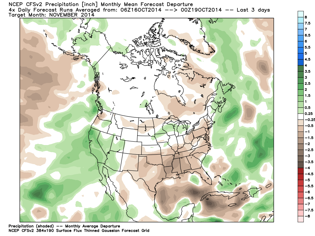
Notice the bulk ot the precipitation pointed right at Northern California. This is similar to what the UK Ensembles are showing for Dec/Jan/Feb.

Here is a look at what the Climate Forecasting System (CFS) is showing for the same December-February time frame.
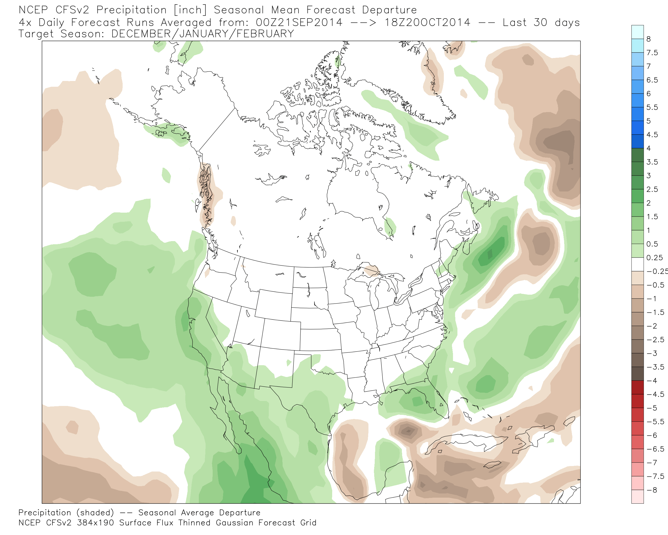
So to try and tie all the teleconnections together to come up with an outlook. We start our season with three different factors that we didn’t have last season. A +PDO, a -QBO, and a weak/moderate El Nino. A -QBO means more occurrences of Blocking in Greenland, leading to more likely occurrences of a negative North Atlantic Oscillation (-NAO) and negative Arctic Oscillation (-AO). These three teleconnections combined with a +PDO normally would support a west coast ridge. If this isn’t confusing to all of you, your first though should be that sounds bad? However two caveats exist: Even a weak El Nino can cause a strong enough southern split of the polar jet undercutting the ridge and sending it into Central and Southern California; secondly when the blocking isn’t occurring over Greenland it is occurring over the upper latitudes of Siberia and the Eastern Pacific, sending the storm track into Oregon and California. To break it down the 60yr long term average with a +PDO, -QBO, and a weak El Nino is 84% of normal. If we have a moderate El Nino it jumps up to 117% of normal. So basically an average winter give or take 15 percent.
Interesting things to Note:
The normal snow coverage for Eurasia south of 60 degrees north this time of year is one million square kilometers, it is currently 5 times that! This lends support to a strong spike in the -AO. Question is, does the outbursts of cold air into the U.S during these negative spikes make it this far west? Do we end up colder than the predicted warmer than normal temperatures? This also causes an increase in the meridional flow (north to south flow of air), which increases upper latitude blocking. This would promote more undercutting of storms into the west coast. The other main thing to take note of is the historically high level of SSTA’s off the coast of Baja, which would help provide fuel for Pacific storms.
The only thing left to discuss is March and April. With the QBO most likely switching to its western phase (+QBO), promoting more mid latitude blocking. With a waning El Nino, as long as there is no warm pool off our coast or the Pacific Northwest, (which is unlikely with an active November-February) we should stay in a progressive flow. Typically this is when winter releases its grip on the East Coast, allowing for more ridging in the east, and more troughs in the west. This pattern brings colder type storms down out of the Gulf of Alaska versus wetter warmer storms off of the Pacific.
So that brings up the topic of snow level’s. Lake Tahoe has always been vertically challenged. In a normal year things tend to happen between 6,500-6,800 feet and above. With the storm track coming straight off the Pacific, we are going to have to watch closely what side of the jet stream Tahoe is on, to determine how much snow versus rain we receive with each individual storm.
Think Snow…
An average winter would be awesome at this point.
Don’t worry, baby due sometime next week, I’ve sacrificed for the greater good. It’s gonna be a STELLA winter in Tahoe!
Thank you sir. I’m going to do my part and wash my car.