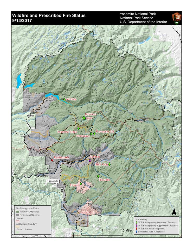
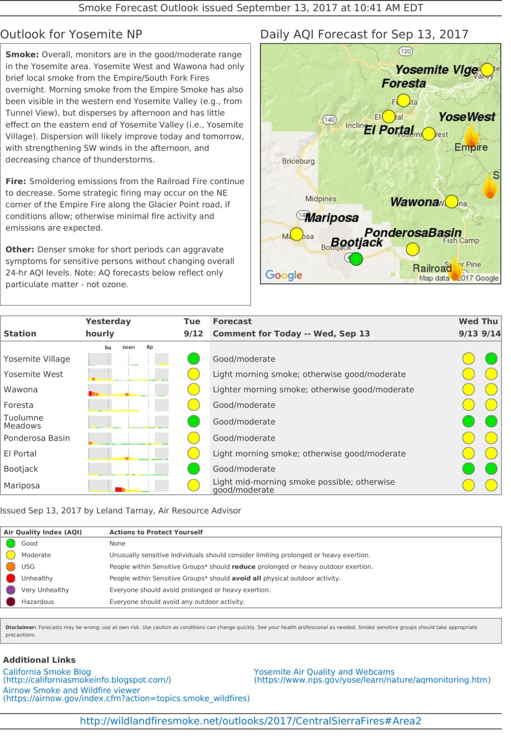
According to Yosemite National Park, there are there currently at least 12 wildfires burning in Yosemite National Park, CA (see map above).
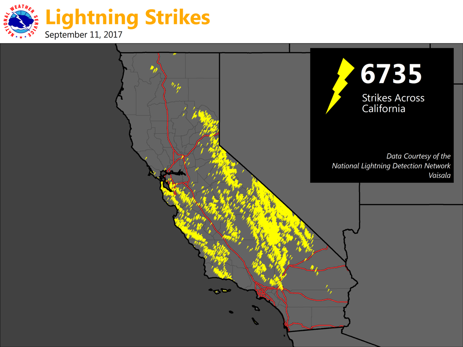
11 of the 12 fires were started by lightning. We’re guessing that many of these lightning ignited fires began via the large amount of lightning strikes (6,735) that occurred in California on September 11th, 2017.
Full details of how Yosemite plans to manage these natural fires below.
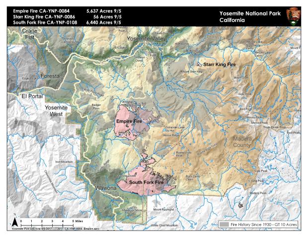
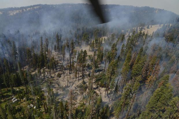
The Empire and South Fork Fires continue to burn within Yosemite National Park. Details on those fires way below. Both of these fires were started by lightning as well.
Glacier Point Road remains closed due to the Empire Fire.
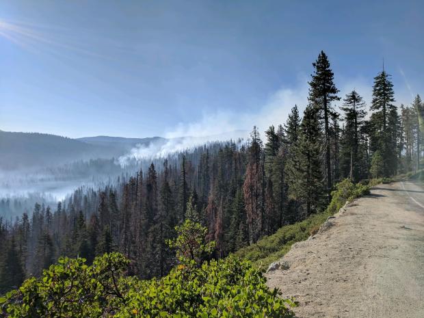
“Expect smoky conditions in Yosemite. Expect poor air quality and limited visibility due to fires in Yosemite.” – Yosemite National Park, today
Despite these fires, air quality in Yosemite is ranked as good to moderate today (see chart way below).
Posted on: 09/13/17 02:47 pm
There are multiple fires burning in Yosemite National Park’s wilderness area from natural lightning ignition.
by Yosemite Fire & Aviation
September 13th, 2017
A Blaze with Benefits: Fire Ecology at Work
Fire and smoke are as much a part of the Yosemite ecosystem as water and ice. Every year, thousands of lightning strikes occur within park boundaries, igniting vegetation made tinder-dry by Yosemite’s long, hot summers.
More than 40 years of fire ecology have taught fire managers that suppressing all fires results in unnatural fuel buildup and only delays the inevitable, and can make fires more severe than they otherwise would have been.
Just as dam operators must let some water spill through their dams in order to prevent floods, fire managers must let some fire and smoke occur to keep the larger conflagrations at bay, especially in mid-elevation, mixed conifer forests where a “flood” of accumulated biomass threatens to be released by severe fire.
Fire managers work to restore healthy forests and reduce the threat of extensive, severe fire by allowing some lightning-ignited wildfires to burn under moderate conditions. They also use prescribed fire and mechanical tree thinning to reduce fuels.
In addition to reducing the risk of severe fire at large scales, wildfires can also help create healthy forests. The current widespread tree mortality event is likely more extensive than it would have been without a century of fire suppression. In addition to the ongoing drought, warming temperature and native bark beetles, fire suppression dramatically increased tree densities, which in turn increased competition for limited water resources.
Wildfires that burn under more moderate conditions can also increase habitat and species diversity across the landscape by burning intensely in some areas and less so in others.
While balancing this need for fire, Yosemite’s fire managers strive to protect the quality and clarity of the air that park visitors breathe. Although wildfires managed under more moderate conditions may have transient, moderate smoke impacts in areas near the fire, it limits the potential for future severe fires that could otherwise cause extremely unhealthy levels of smoke for extended periods, over a much wider area.
Despite the ecosystem health benefits of wildfire, managers will suppress wildfires that threaten homes and infrastructure.
Yosemite Fire Information and Updates
South Fork Fire Update #30 September 13th, 2017September 13, 2017
Fire remains quiet near the community of Wawona on the west and south flank of the fire. Sections of the north flank and the entire east flank are continuing to burn in the wilderness. Showers and thunderstorms are possible each afternoon and evening through Tuesday, with a slight increase in temperature and lower relative humidities. Gusty and erratic winds are possible with any thunderstorm that develops. Empire Fire Update #38 September 13th, 2017September 13, 2017
Fire activity was minimal yesterday due to increased relative humidity and precipitation from the last couple days. If conditions are favorable today fire crews will continue burn operations along Glacier Point road. Glacier Point road remains closed until further notice due to fire operations. Showers and thunderstorms are predicted this afternoon through Thursday with cooler temperatures and higher relative humidly through the end of the week. Fire Update September 13th, 2017September 13, 2017
There are multiple fires burning in Yosemite National Park’s wilderness. Showers and thunderstorms are possible each afternoon and evening through Thursday with increased relative humidities and cooler temperatures. Gusty and erratic winds are possible with any thunderstorm that develops. |
EMPIRE FIRE UPDATE:
September 13th, 2017
Approximate Location
37.644 latitude, -119.618 longitude
Incident Overview
Fire activity was minimal yesterday due to increased relative humidity and precipitation from the last couple days. If conditions are favorable today fire crews will continue burn operations along Glacier Point road. Glacier Point road remains closed until further notice due to fire operations. Showers and thunderstorms are predicted this afternoon through Thursday with cooler temperatures and higher relative humidly through the end of the week.
Fire crews are implementing a perimeter control strategy for the north, west, and southern flanks of the fire to protect Bridalveil Campground, Yosemite Ski and Snowboard Area, Yosemite West subdivision, Wawona Road (Highway 41), and Glacier Point road. Today crews will continue work along Glacier Point road on the north flank of the fire. The west and south flanks of the fire are contained, holding, and will continue to be monitored by aircraft and fire personnel. Areas of new smoke may be seen as the fire cleans up areas of unburned fuel interior. The east flank is being allowed to move towards the Illilouette basin to continue to enhance forest resiliency in a fire adapted ecosystem. Yosemite National Park has managed fire in this wilderness area for decades. This area is very steep and rugged, with numerous natural barriers and minimal values at risk.
Yosemite West and Wawona had only brief local smoke from the Empire fire overnight and some morning smoke in Yosemite Valley, which disperses by afternoon. Smoke dispersion will improve today and tomorrow with strengthening southwest winds in the afternoon and decreasing chance of thunderstorms. Fire Managers are working with the local Air Quality Districts and will be monitoring smoke impacts to the park and local communities.
Basic Information
| Current as of | 9/13/2017, 12:37:38 PM |
|---|---|
| Incident Type | Wildfire |
| Cause | Lightning/natural |
| Date of Origin | Tuesday August 01st, 2017 approx. 08:45 AM |
| Location | 1 Mile east of Badger Pass Ski Area, directly adjacent to Bridalveil Crk. Campground n Yosemite’s Wilderness |
| Incident Commander | Eric Messenger, ICT3 |
| Incident Description | Management |
Current Situation
| Total Personnel | 43 |
|---|---|
| Size | 6,200 Acres |
| Percent of Perimeter Contained | 55% |
| Fuels Involved | Red Fir Timber (Litter and Understory), Dormant Brush, Hardwood Slash
Pockets of green leaf manzanita and chinquapin brush as well as heavy dead and down material |
| Significant Events | The following trail and area closures are in place until further notice:
• Glacier Point Road • Bridalveil Campground • Ostrander Trail • Bridalveil Trail • Alder Creek Trail • Mono Meadow Trail • Turner Meadow Trail All closed trailheads and junctions will be posted with a trail closure order and map. |
Outlook
| Planned Actions | Burn out northeast corner of the fire. Continue to patrol and hold the south flank of the fire to ensure this critical section of the fire is secured. Hold the west side. Continue to monitor and collect intelligence on the east side of fire, by hiking to high points and recon with helicopter. |
|---|
Current Weather
| Weather Concerns | An upper low off the coast will continue to provide a threat of showers and thunderstorms across much of central California through Tuesday. The thunderstorm threat will continue mainly over the Sierra Nevada through Thursday. Otherwise a cooling trend and an increase in relative humidity values will be present through the end of the week. |
|---|
Posted on: 09/03/17 11:37 am
SOUTH FORK FIRE UPDATE:
September 13th, 2017
Approximate Location
37.538 latitude, -119.598 longitude
Incident Overview
Fire remains quiet near the community of Wawona on the west and south flank of the fire. Sections of the north flank and the entire east flank are continuing to burn in the wilderness. Showers and thunderstorms are possible each afternoon and evening through Tuesday, with a slight increase in temperature and lower relative humidities. Gusty and erratic winds are possible with any thunderstorm that develops.
There may be some burning well interior and visible smoke with increased winds due to the storms. The fire will be monitored by aircraft and fire lookouts. As fire burns into the high country wilderness it will burn actively through pockets of dense vegetation but will then slow down as it progresses into sparse vegetation and natural granite barriers limiting smoke production. This high country wilderness area has minimal values at risk.
Yosemite West and Wawona had only brief local smoke from fires overnight and some morning smoke in Yosemite Valley, which disperses by afternoon. Smoke dispersion will improve today and tomorrow with strengthening southwest winds in the afternoon and decreasing chance of thunderstorms. Fire Managers are working with the local Air Quality Districts and will be monitoring smoke impacts to the park and local communities.
Basic Information
| Current as of | 9/13/2017, 12:44:26 PM |
|---|---|
| Incident Type | Wildfire |
| Cause | Lightning |
| Date of Origin | Sunday August 13th, 2017 approx. 02:30 AM |
| Location | .75 mile east of the community of Wawona |
| Incident Commander | Eric Messenger ICT3 |
| Incident Description | Supression |
Current Situation
| Size | 6,840 Acres |
|---|---|
| Percent of Perimeter Contained | 47% |
| Fuels Involved | Timber (Litter and Understory) Brush (2 feet)
Fuels with-in the fire vicinity are mixed conifer, red fir, oak, and brush. In the immediate area the fire is experiencing quick drying trends. Fuels contain areas of beetle mortality. |
| Significant Events | The following trail and area closures are in place until further notice:
•The Swinging Bridge Trail on both the north and south sides of the South Fork of the Merced River. •The Chilnualna Falls Trail from Wawona Trailhead to the top of Chilnualna Falls. •The two mile connecting trail heading north from the top of Chilnualna Falls to the intersection of the Buena Vista Trail. •The Chilnualna Creek Trail from the top of Chilnualna Falls east to the intersection of the Buena Vista and Buck Camp trails (Just east of Johnson Lake). •Turner Meadow Trail •Turner Meadow intersection east to Buena Vista trail •Off-trail areas in the vicinity of the South Fork Fire Area, including the swimming holes north of Chilnualna Creek. • All climbing routes on and around Wawona Dome are closed. |
Outlook
| Planned Actions | South Fork fire will be monitored by air, and from lookouts near the fire. |
|---|---|
| Projected Incident Activity | 12 hours:
Fire is actively backing and flanking to the east. 24 hours: Fire is actively backing and flanking to the east. 48 hours: Weather forecast is for lower temperatures and higher relative humidity which should moderate fire behavior. |
Current Weather
| Weather Concerns | An upper low off the coast will continue to provide a threat of showers and thunderstorms across much of central California through Tuesday. The thunderstorm threat will continue mainly over the sierra Nevada through Thursday. Otherwise a cooling trend and an increase in relative humidity values will be present through the end of the week. |
|---|